

fountainguy97
-
Posts
1,027 -
Joined
-
Last visited
Content Type
Profiles
Blogs
Forums
American Weather
Media Demo
Store
Gallery
Posts posted by fountainguy97
-
-
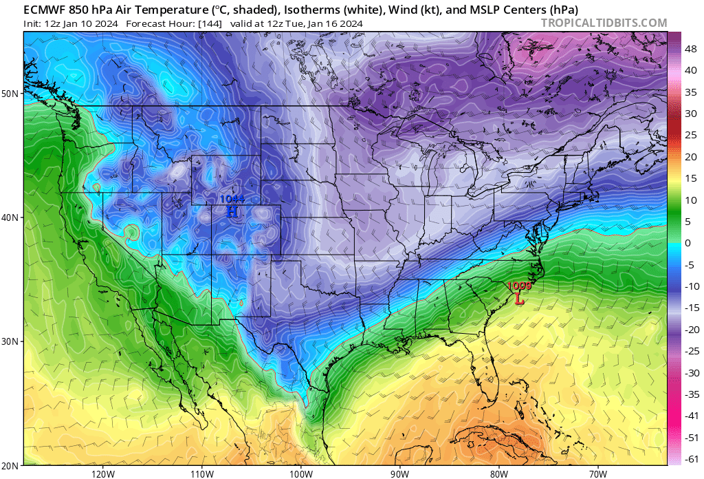
Yeah this run won't do anything for us but a major trend toward euro with holding back the energy. Euro leading the way.
-
 1
1
-
-
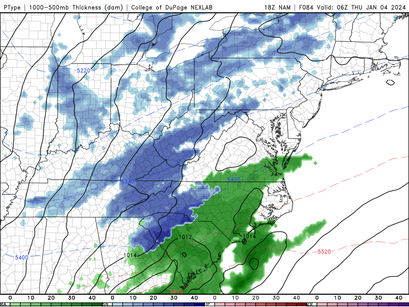
18z gfs defitnely a big shift toward EURO with more focus on holding back that piece. Initial frontal stuff dies out.
-
1
-
-
21 minutes ago, Carvers Gap said:
If this is correct and it makes sense....
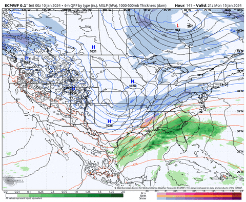
I think the front running cold front(which dies out) will send precip out ahead, the rest of the energy holds back along the GOM as the cold front hits the GOM, and then dynamite. I have been wondering how a strong cold front like that didn't create a storm. The Memphis system a few years back slowed and there was overrunning. Cold air like that is notorious for just oozing southward. Many great storms of the past have their genesis along a strong Arctic boundary that stalls. It is possible/plausible that this could all get squashed, but the energy is gonna have to go somewhere. I don't think it will just burn out over Louisiana. It certainly could go out to sea. But....a strong storm would likely trend Northwest. I feel a bit better about having seen the GFS and CMC try the same thing. Plus, several ensemble members have been well south of the operational. I think we have noted over the past couple of days that the ensemble means were well south of the operational. Now, what we need to see is the ensembles and operationals converge on a track like the Euro just had. Let's hope the operationals are not moving completely to the suppressed ensemble means from the past few days.
Thats a good summary. Models seem to be trending more toward the holding back solution but I hope we don't end up in an awkward inbetween solution where the front is dead and the back energy is too late
-
1
-
-
3 minutes ago, Carvers Gap said:
JB called it this morning. He said that operationals(euro specifically) were too amped. I have noticed multiple ensemble members which were sliders or even went into the Gulf States as a slider. Not many have turned the corner like the Euro just did, but the solution has been there buried in ensembles. It might be the primary solution. I thought it might just be smoothing. JB noted that high pressure over the top should flatten it out. It looks to me like models are abandoning the anafront, holding energy back after first flattening the front. It almost creates an overrunning event over TN.
But that's the question. Does this just flatten into a non-event? Verbatim euro is basically a swing and a miss for the SE with a late blooming surface low. I guess the ceiling is much higher with this look but it'll be easy for this to be too late for most of the E US besides New England.
-
1
-
-
1 minute ago, Carvers Gap said:
This looks like it could be big......

-
5
-
-
1 hour ago, Holston_River_Rambler said:
This is high stakes territory snowbird, we've reached the land of "extrapolate the NAM"
"I swear bro. The NAM has this one nailed. Trust me"
someone start the thread. My last one went poof haha
-
5
-
 3
3
-
-
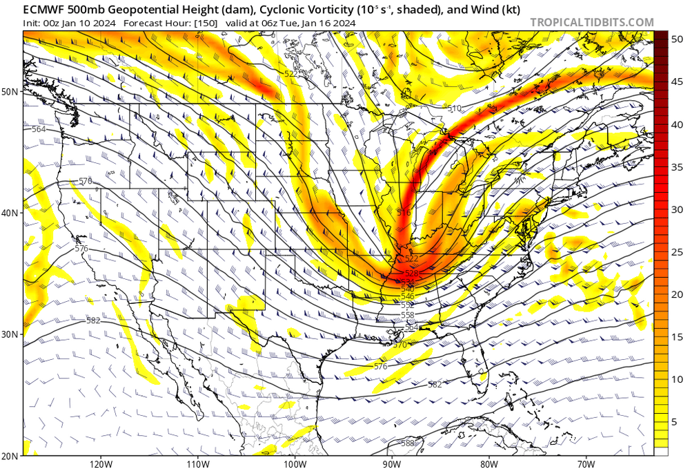
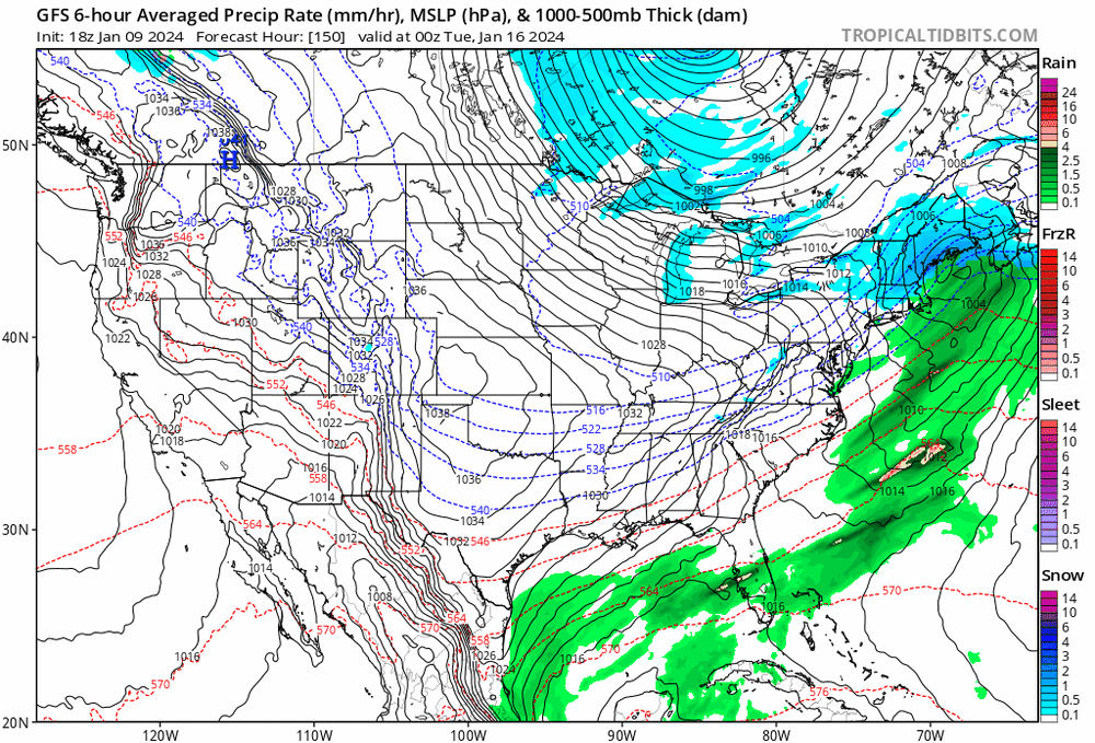
7 minutes ago, Holston_River_Rambler said:
It's the control, so the resolution is lower, but it looks quite a bit slower that the OP for one thing.
Here is the 0z OP for the same time:

The end result might not be any different, but I like the idea of 2 shortwaves interacting near the MS river and Gulf coast:

There's room to amplify and a semi phased shortwave trough to go negative at the right longitude for us.
You can see it trying to do it on the 0z Euro.
See how as the shortwave (indicated by the blue lines) rolls overhead precip increases pretty quickly over east TN.
Maybe if it can dig more and slow a bit we get more of a Miller A type solution.
Yes I believe that's a suitable outcome for all of TN. Middle/west gets the frontal aspect and then the lingered shortwaves backfill the front as a low pops for the east.
it's not worth much the but 12z NAM is in line with the euro of a slower and more solidified "backend" shortwave (I guess that's how we will call it)
-
3
-
 1
1
-
-
The winter of dustings continues today. I've had 6 snowfalls. 3 Trace and 3 dustings. The frustrating thing is almost every snow looked better and then fizzled short range. I've spent so much time at 33-35 and snow this winter.
-
4
-
-
1 hour ago, Carvers Gap said:
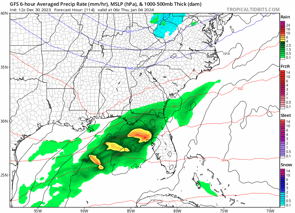
Models still bouncing around all over the place. I swore years ago never to track a storm from seven+ days out. Now, I remember why. Not again after this one. LOL. Yeah, east -> west trajectories are not how we score in most of the eastern valley. There has to be a component where the system backs(slp forms to our east) and preferably a component where moisture comes from the southeast or even southwest(even w/ the risk of a warm nose). Really, I don't think clown maps are going to matter with this one. What is going to matter is how much moisture is on the qpf map for each area. What I will be watching is how much moisture is going to be available. If areas get 0.2 - 0.3 (water equivalent), that "could" be really good if the precip line is far enough behind the front. If the precip arrives with the front, totals will be much lower. So things to watch for me are where the precip is in relation to the front and overall precip amounts for the event. Even at TRI where this has been a strong "no go" for days, if we get 0.1" of water...that could be a couple of inches of snow. For now, I still think the eastern valley is going to need a lot of help as you note. I think a general 1-2" of snow is in play for most eastern areas. To get above that, we are going to need something similar to what you have shown.
FWIW, the 6z GEFS trended way down on storm totals, but it is still bouncing around.
Yeah need that backing into the cold boundary from a developing coastal. Probably need a thread for 12z. Mid-west TN basically a lock for some frozen
-
For people East of the Plateau you want the EURO to keep trended for a negative tilt. The only way we score is if we get a low to form and fire convection. If not then yes. The moisture will go poof.
the good news is the gfs is ticking that way but still not enough. That's the only way this brings much of anything to Eastern areas.
Need this to continue. We don't need an 1" of precip with this. Its so cold just need a few hours of good rates.
-
3
-
-
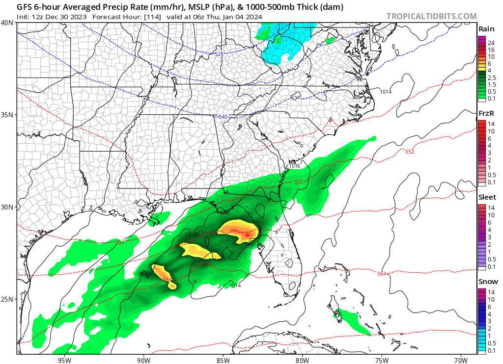
This one feels feast or famine. It's either a major event or it's clear skies.
Our energy is still over 4 days from being onshore and we have another system to deal with this week too. Still just warning shots but a good sign is that we have cross model support.
I personally don't like the looks of this one especially for ETN. But really for anyone. This is one of those storms that will be a pain in the rear to track. It'll be easier to squash this into the ocean vs amp IMO. I hope I'm wrong
 we have lost most support for an amped version with most of 12z a whiff besides EURO. In normal circumstances I would argue that's right where we want it (for middle and west regions). I'm taking the sit back and relax approach. Let's see what we have come Friday when it's only 2 days from being onshore.
-
2
-
-
2 minutes ago, Carvers Gap said:
It is also very important to look at ensembles. The means for the 6z GEFS and 0z EPS actually suppress the system like the CMC does, rotate the energy below the forum, and bring it up the coast. Maybe that is where we want it? Maybe not. But I will say, I do think the operationals are driving the bus and catching trends that the ensembles are likely washing out. Operational trends matter at this point.
Yeah gfs is coming toward euro which is our miller A. Gefs is very suppressed as is EPS. Thats a good sign that maybe the OPs are on the northern end of guidance. It's possible that means we won't see a massive north trend. Just speculation at this point.
we have 2 major systems (1 ongoing 1 to come) before this one is next up to bat. Long way to go but it is probably the best look of the season so far.
-
2
-
-
Just now, Carvers Gap said:
A slp in central Georgia (tracking to Hatteras) is not what we want in E TN.....What we want is a slp tracking from the Panhandle to Hatteras. Anything more northwest creates downslope in E TN and wrecks thermal profiles. At this very minute, it isn't terrible...but if it takes a likely NW jog, adios for many. An anafront is a much easier solution, and more predictable. That said, having a blizzard on a big cold front is very realistic.
This has been my reservation for this system. This screams cold rain for E TN. But the other portions of the state are due!
-
1
-
-
NAM'd
-
11
-
-
4 minutes ago, Carvers Gap said:
I must say, the late night crew put up some great content. Awesome, ya'll! Tracking on NYE....that is a good thing.
Love seeing all the input! We have nice crew of posters here these days! 12z inbound!
-
5
-
-
North trend for the win? Right where we want it honestly.
I know focus will be on the "big dog" after this one but our last event trended way south around the 5 day mark but came roaring back north in the 2-4 day period. Watch for this to potentially do the same. There are still GEFS members with some northern solutions.
We need a faster ejection of the southern piece and a slower northern to get that negative kick to pop the surface low further north.
Trailing piece could be the bigger story. A lot of times we get the "setup" system and then the trailing delivers the goods. Best chance of the season for winter action for the Southeast so far! This first week of Jan has been in the discussion for a while now. Glad to finally stop kicking the can and see some verification in the mid-range.
-
6
-
-
3 hours ago, Carvers Gap said:
As for why the snow record is messed up?
I don't know, but is is missing snow for sure. I do know that the scientific method involves hypothesis, collecting data, and then making sound decisions based upon that data. Data will often tell us if we are right or wrong in our hypothesis. Bad data will often give us incorrect results. Corrupt data makes it very difficult to find the truth.
When we set out with a preconceived notion of truth, and don't bother to look to see if data follows our thinking....we may miss bigger truths. I get super uncomfortable when people (who ask good questions) are seen as crazy or just sidelined. Now, all of us probably get irritated when someone maybe implies that we are wrong. Nobody likes being wrong. But when cooler heads prevail, often we don't mind it. So, with that in mind I will say this.
Is it warmer than it was 30 years ago? Yes, especially at higher latitudes of the northern hemisphere.
Am I getting less snow? Maybe. Maybe not. I think higher latitudes in the northern hemisphere are certainly seeing much less snow. I think there are fewer big storms IMBY. Summer lasts longer, but spring seems to come later(not this year I don't think).
Is it due to manmade causes? Possibly. But it could also be something which we do not see, and maybe that worries me the most. It bothers me to see people have to accept things that may or may not be true or may be partially true. This could also be a much larger cycle that we don't understand. My overall belief is that if we can produce less pollution, that is a good thing no matter what side of the aisle one is. Is it reasonable to eliminate all pollution? Probably not at this stage in history, and that is probably not realistic. But I still want my grandkids to breathe clean air, drink clean water, catch fish/hunt, and have wild places to visit. But I also do like plentiful electricity, A/C, cars, planes, and computers.
Are data sets being corrupted to fit an agenda? Yes, and I don't completely understand why. I have my theories, but will probably keep those to myself for now. The last four or five years certainly don't give me that comfy feeling that I am being told the truth. For all of those reasons, I think asking great questions, listening to others with different opinions, and being a critical thinker are important, just as they always have been. I don't like group think, and sometimes I think when questions are not asked...there is a risk that we have confirmation bias. The missing data does make me think that confirmation bias is in play.
I agree. But I never really thought the poor snow records were trying to maliciously change the trends of climate here but now that you mention it I wouldn't be surprised. When I go back and look at historical events it's just sad how poor snow records are. I have seen official measurements easily half the actual amount for my area.
a few years ago they secretly unveiled a new algorithm for measuring sea ice area and volume which very coincidentally increased numbers pre 2015 and lowered numbers post 2015...
even with all the fiddling of numbers they still can't manage to create a new record low sea ice in the Arctic for the headlines lol. Are things changing? I believe so. Buts it's a fluid system to begin with.
When I see urban heat islands of 10-15 degrees in the summer which hundreds of climate stations are in I wonder how they can somehow say all that asphalt isnt skewing numbers higher?
Just doesn't sit well with me. On top of that any political hot topic is bound to be riddled with second agendas and goals..
-
2
-
-
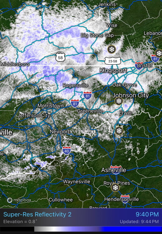
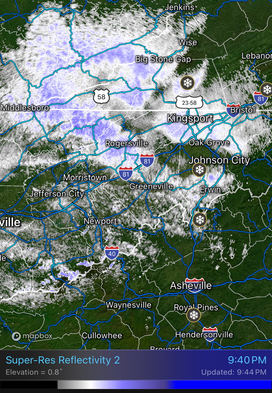
Man those streams of moisture building on radar the last few frames look stout. If we can get down to 32 this will stack on quickly. I've been hovering between 32.5 and 33.5 all day.
-
1
-
1
-
-
Nice moderate snow for about 4 hours today but temps were at 32.5-33 so no accumulation. beautiful day regardless! Feels like winter!
-
4
-
-
1 hour ago, Carvers Gap said:
If this storm for the 4th is still there tomorrow evening or even Sunday morning, probably time to post a thread. The ICON has it. The 18z GFS has it w/ a slight jog SE(which is where we want it). I mean really, I might be interested enough to stay up and watch models at 0z. It looks that good. The Euro pushed it similar to the GFS trend at 18z...so edit, it looks cautiously decent.
Yeah this one has support across all model families which we haven't had yet this winter really. Perfect spot for the inevitable NW jog thats coming
-
1
-
-
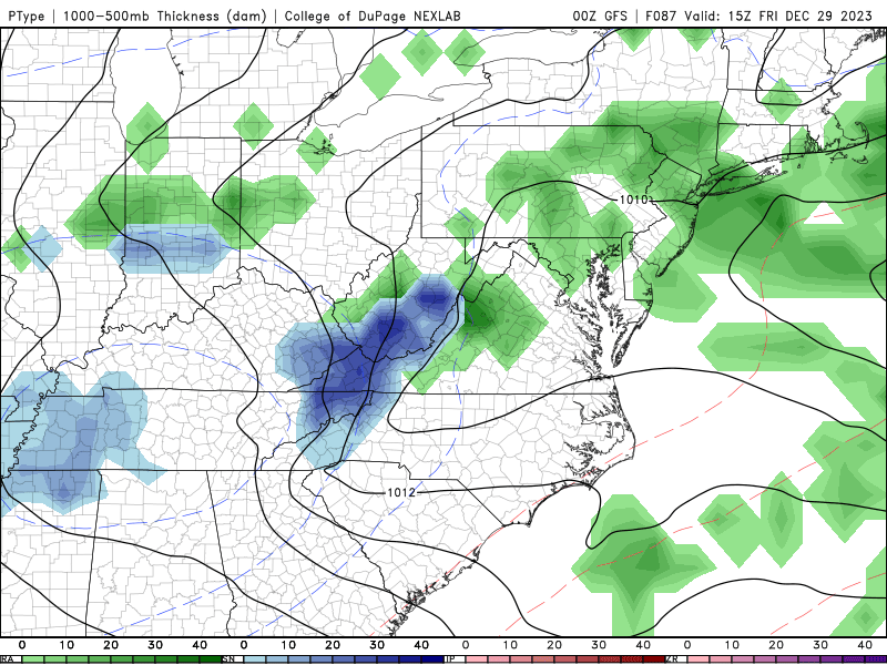
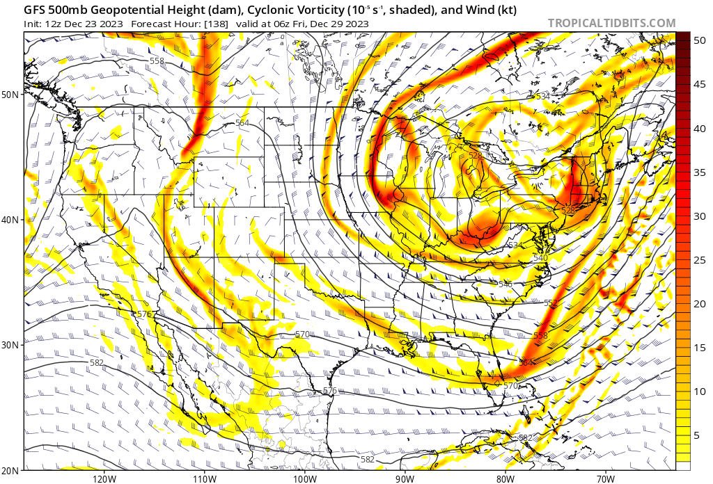
What a strange system this is shaping up to be. A random chunk of precip just sits over tri-cities into WV for over a day as the ULL slowly churns.
not sure I've ever seen anything like this. Trends are for more separation and the ULL to remain closed off longer which is good for snow. Need that to continue.
-
8
-
-
18z gefs with the best mean yet. Looks like this one is legit. The start is almost on high res models believe it or not.
looks like a 36hr event in the mountains. Pretty typical in the higher end NW events. The high res are going to be pretty for sure haha
-
5
-
-
GEFS taking a big jump overnight with our NW event.
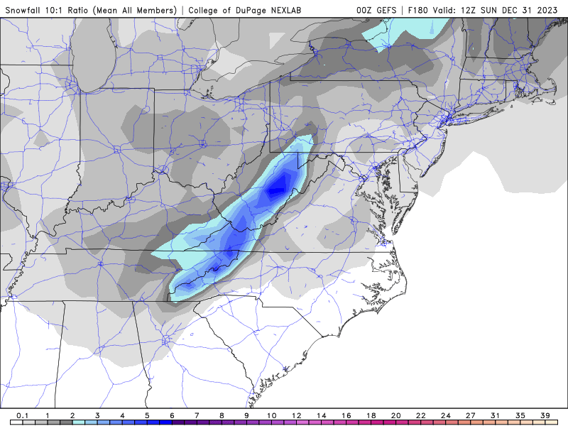
wow big changes on the 06z gfs. 3-4 isobar closed ULL now.
-
6
-
-
Dig this a few hundred south and it's a multi-day NW snow event with temps in the low 20s
-
6
-


January Medium-Long Range Discussion
in Tennessee Valley
Posted
Yes that 18z run was probably about to bury someone