

fountainguy97
-
Posts
1,027 -
Joined
-
Last visited
Content Type
Profiles
Blogs
Forums
American Weather
Media Demo
Store
Gallery
Posts posted by fountainguy97
-
-
1 minute ago, Stovepipe said:
Took the words right out of my mouth, I was just about to post Rufus!
If it catches on we will take 50/50 credit haha!
-
 1
1
-
-
9 minutes ago, John1122 said:
12z RRFS A (really need a nickname for this)
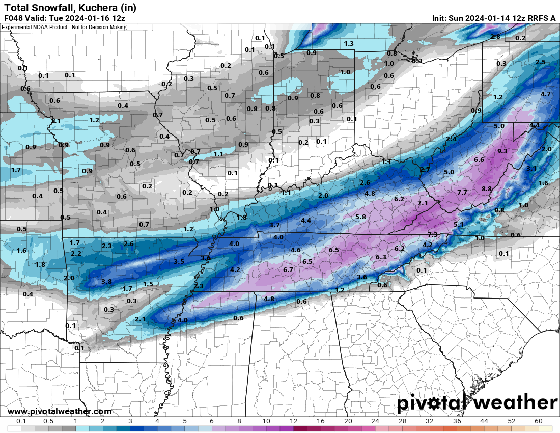
Rufus!!
-
5
-
 1
1
-
 1
1
-
-
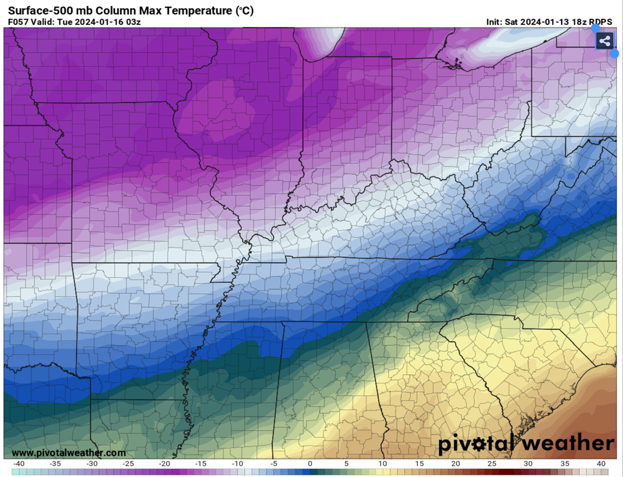
finally, the RGEM caves and almost all eastern areas remain frozen.
-
1
-
-
33 minutes ago, Carvers Gap said:
And this isn't about betting or winning or losing.
Speak for yourself. No mercy over here
 it's bullseye in my backyard or this is the largest bust of all time.
seriously though the reason I'm here and not elsewhere is because no one here lets their backyard determine if a model is good or bad. Can't be said for others.
-
3
-
3
-
-
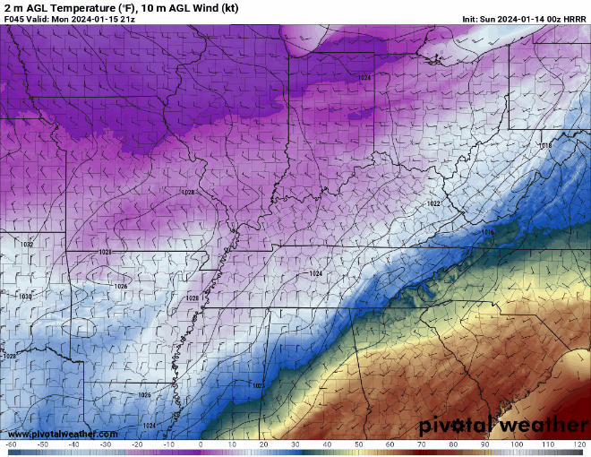
Little bit more warm nose for me. I'll probably Mix for 3-6 hrs but hopefully you guys stay all snow!
-
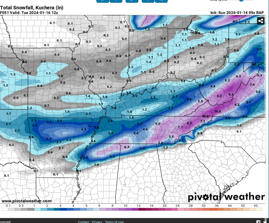
The RAP is just absurd. All frozen!
(does anyone else find it annoying you have to screenshot pivotal on mobile??)
-
3
-
-
13 minutes ago, TellicoWx said:
Looking at the 6z runs so far, think they are right. You can almost trace the spine of the Apps from WV thru TN with the accum maps.
I noticed that as well. I do find it hard to believe the RGEM scours out the cold. I go from 21 to 36 on the RGEM Monday with snow falling. Doesn't add up.
-
Yep! RGEM pushing in more cold. One more tick at 12z and I'm happy haha
hrrr and RGEM absolutely crush eastern portions while NAM nearly blanks the same locations..
-
1
-
-
4 minutes ago, John1122 said:
I take that back. The NAM was colder over Knox Co and didn't have the p-type issues so instead of 3.5 inches Knox was covered by 7+ inches on the 12k. The 3k still has the p-type issues along and S of 40.
Yeah 12km is a minor tick better for eastern areas but still a massive difference between hrrr and NAM. Inside 24 hrs now...

-
Still snowing on hrrr too lol
it's razor thin but keeps me frozen the entire event.
NAM looks good too! A tick south. Update: better early on. Nasty warm nose still later.
-
1
-
-
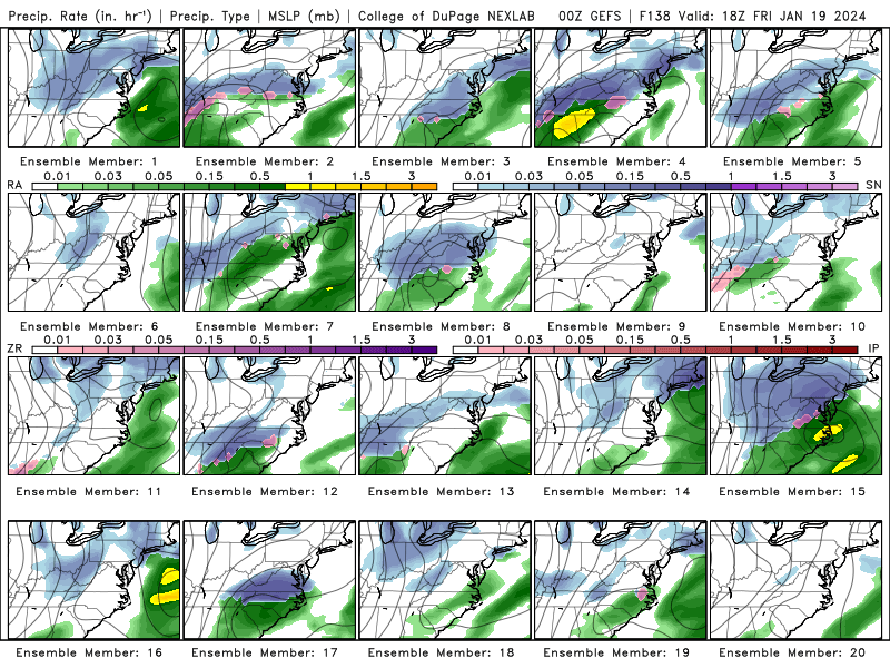
the GEFS is super aggressive on the 5 day threat
-
4
-
-
Man I feel much more optimistic for extreme eastern areas such as myself after 00z. Pretty much all high res keep temps below 32 to the border except the NAM (which jumped SE in a big way) and the RGEM. Hopefully the RGEM can get on board with more cold push by 12z!
-
1
-
-
24 minutes ago, Carvers Gap said:
The RGEM is my "go to" from this point forward in the chase...for the eastern valley.
I agree. Let's get that cold push all the way to the border and I'll be happy

-
1
-
-
FWIW the WRF family of models and the fv3, and the RAP, are like the hrrr with the cold push all the way to the state line
-
6
-
-
RGEM still mixing for the east but technically every so slightly more cold push. Tiny tiny shift lol
-
1
-
-
5 minutes ago, Stovepipe said:
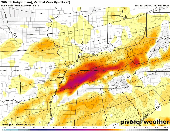
Would you mind posting a picture of this? I'd like to start monitoring it. Thank you for the insight!
Vertical velocity at the 700mb will show you the clearest picture of the best dynamics and lift (which is always the right entrance region) The nam has been trending massively toward other models
-
2
-
1
-
-
Nam cut the distance in half toward the other models. As a result temp profile will be better for most. Still not all the way but a big jump.
-
3
-
-
Just now, Stovepipe said:
0z NAM looking significantly better for east TN, whew.
Much better cold push so far!1
-
3
-
-
For those on the Eastern side worried abt temps... the 00z hrrr and 18z RGEM are very similar as far as precip alignment and placement. But look at that cold push on the hrrr. Much much better. Even keeps my lonesome self below 32. The rgem seems to just be amping hard and eroding that boundary. But the hrrr is proof there is a solution that delivers even for extreme ETN.
-
4
-
1
-
-
9 minutes ago, Hurricaneguy said:
I’m about to stick a fork in East TN. It’s been horrible trends the last 24 hrs. I feel we will be lucky to see 2” in the upper valley. Hopefully we get a good system come through in Feb. We are ridiculously overdue a good snow.
Not at all. Greene county looks good. At worst a couple hours of freezing drizzle.
if anyone should stick a fork in it it's me haha. This is the one time me being tucked in the mountains in Unicoi county is a bad thing. Even then I'll see some frozen which is a win. You guys further east in the valley haven't had a setup this good since I moved here which has been 4 winters. Reel it in!!
-
4
-
-
-
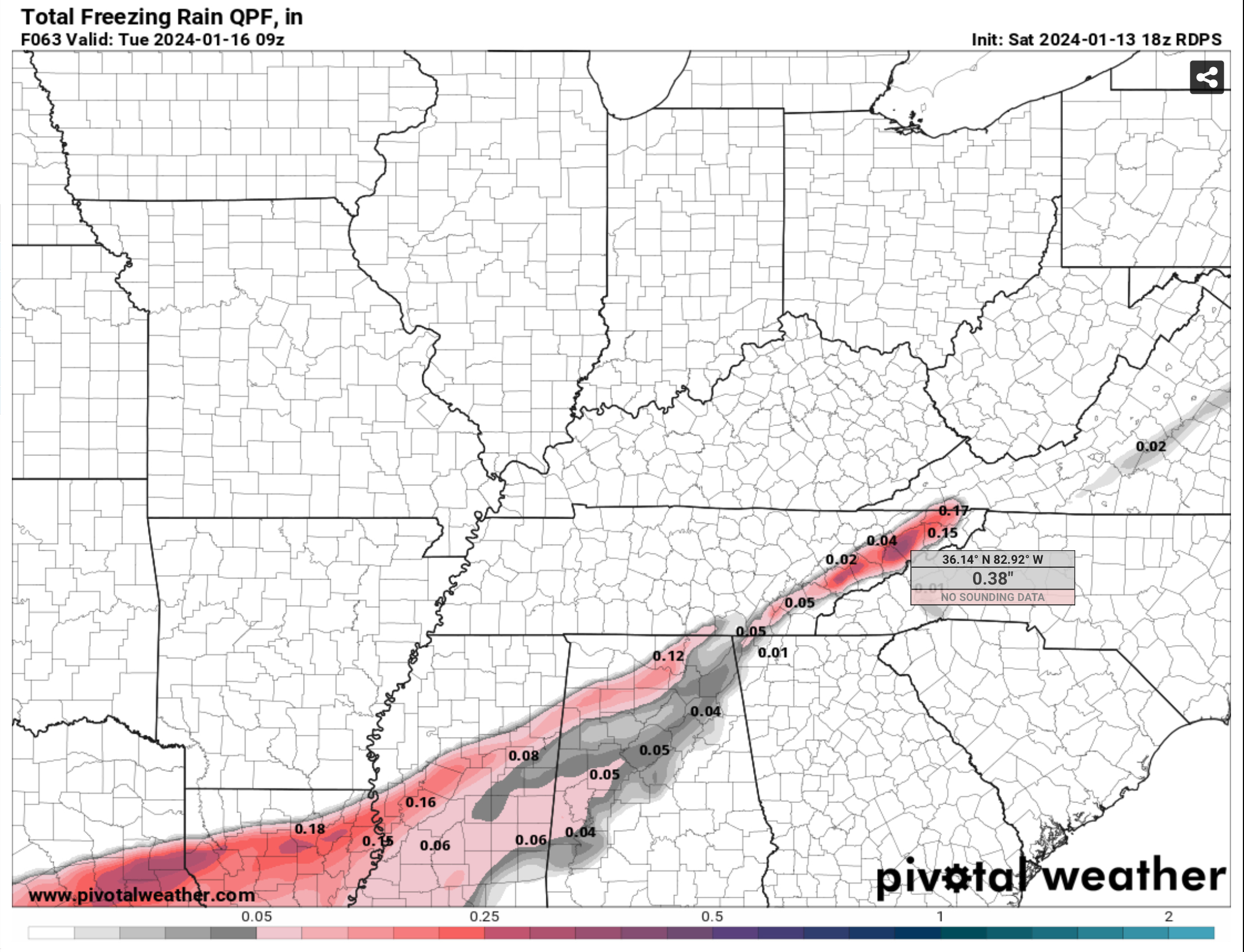
going to be quite a bit more zr this run.

-
Big warm air push into ETN end of hrrr.
Bring back the low teens and snow haha
-
8 minutes ago, PowellVolz said:
Serious question about the DGZ… obviously I know what it is but what is the depth of it? Is it a shallow layer in the atmosphere or does it continue up into the atmosphere? I guess what I’m asking is… the lack of snow in the mountains, is there ever a situation where Mt Leconte could be above the moisture feed?
.Mountain counties are warm nosed. Rain/freezing rain. On rgem atleast. It's not a qpf problem or anything. It's temps.
In fact, the rgem warm noses a larger portion of ETN this 12z all the way through Johnson city.
-
1
-

January 15th-17th 2024 Arctic Blast/Snow Event
in Tennessee Valley
Posted
Probably large enough event to make an OBS thread