

fountainguy97
-
Posts
1,027 -
Joined
-
Last visited
Content Type
Profiles
Blogs
Forums
American Weather
Media Demo
Store
Gallery
Posts posted by fountainguy97
-
-
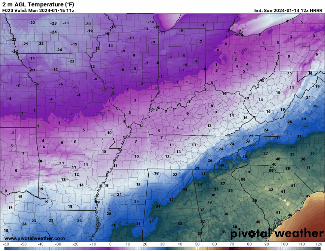
3-4pm will be the height of daytime heating. If we stay frozen through that good chance we remain for duration.
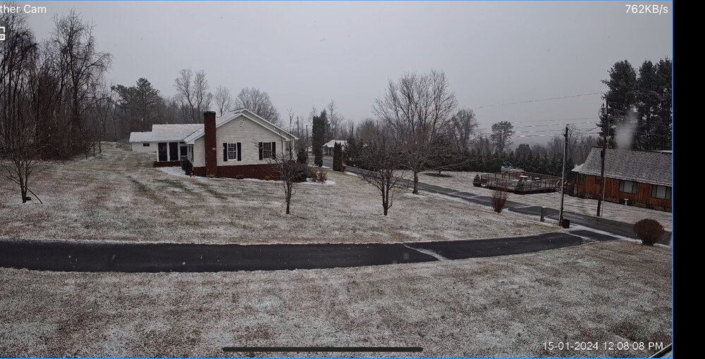
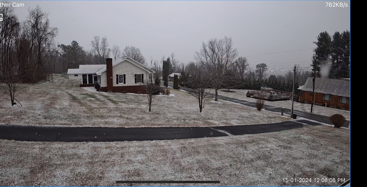
32.7 hanging on to the snow!
-
 5
5
-
-
Roads white. Even interstates. Half dollars falling! 32.5
-
5
-
-
31.8 Beautiful snow. I'll take this as an absolute win.
-
5
-
-
Beautiful snow. Roads turning slushy and white. Hate we are abt to cross 32 here.
-
1
-
-
Honestly this couldn't be worse timing. Needed this overnight and it's a different ballgame.
-
2
-
 1
1
-
-
Here comes the warm push. Temp rising rapidly to 30.9 now. Mulch is white. Grass is spotty white. Considering I was expecting mostly rain this is a win!
Changeover to rain coming in the next hour or two.
-
5 minutes ago, Hurricaneguy said:
It's off and on flakes here in Greeneville. I felt good the mix line would stay to our south but Im not encouraged by the widespread reports of mixing especially this early in the day.
Back to snow/sleet. Wonder if it's moisture driven? Probably is for me. But idk abt over there.
-
1
-
-
Temp 30.0 I have switched to sleet/drizzle in lighter rates. The closest model to my temps right now is the gfs and fv3. Meso models arnt even remotely close.
regardless I am mixing and signs of mixing are widespread at the moment
-
1
-
-
Down to 29.8 holding the line over here in ETN! Lol the 12z hrrr had me 34 at this time
it seems snow came a couple hrs early and has helped lock in the cold. Need rates to stay steady. We will see what happens as the sun really cranks up
-
1
-
-
6 minutes ago, tnweathernut said:
Not going to lie. HRRR is pretty "cringe" for anyone just west of the apps..... Snowing here in Erwin, guessing a 1-2 mile visibility.
Yeah I'm at 30.2 and actually dropped from 30.4 under this snow. How long can I hold out before the transition?
hrrr was already above 32 hrs ago for me.
-
Just now, Utvols235 said:

I’m in the yellow and we have flurries at best right now. Hoping something changes
.The line will shift south very slowly today. Issues then will be daytime temps. I really think timing has hurt us a lot on the edge.
-
1
-
-
Well precip is abt 15 min away and my temp is 29.3 dew of 27. It's risen a degree since 6:30am. Hrrr initialized my area above 32.
let's see where this goes
-
2
-
-
8 minutes ago, Tucker1027 said:
Chattanooga is going to get screwed… not sure I’ll even see an inch
.I'm right there with you lol latest hrrr actually barely gives me a flake here in Unicoi. Nice cold rain.
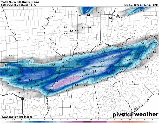
Congrats to the others! If you get 2-4" from this you officially have more snow than most mountain areas so far this winter except the extreme isolated high peaks.Warm nose will not be denied for the boarder areas.
-
1
-
-
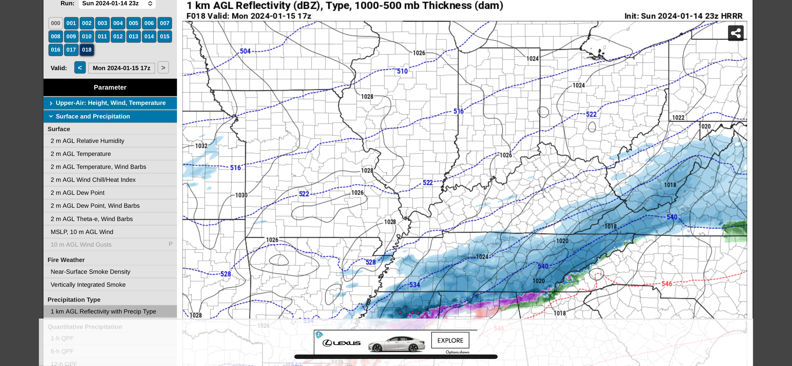
14 minutes ago, tnweathernut said:
And this is the last hour of that model…. 17z. (12 noon). Most of what falls in east TN comes tomorrow after this time and into the evening. Still looks good to me.
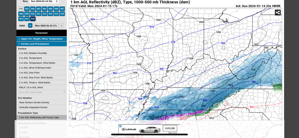
Yeah I'm pointing out the trend. Still trending north. Which will impact totals yet to fall.
-
3
-
-
Don't do this to us hrrr.
-
3
-
-
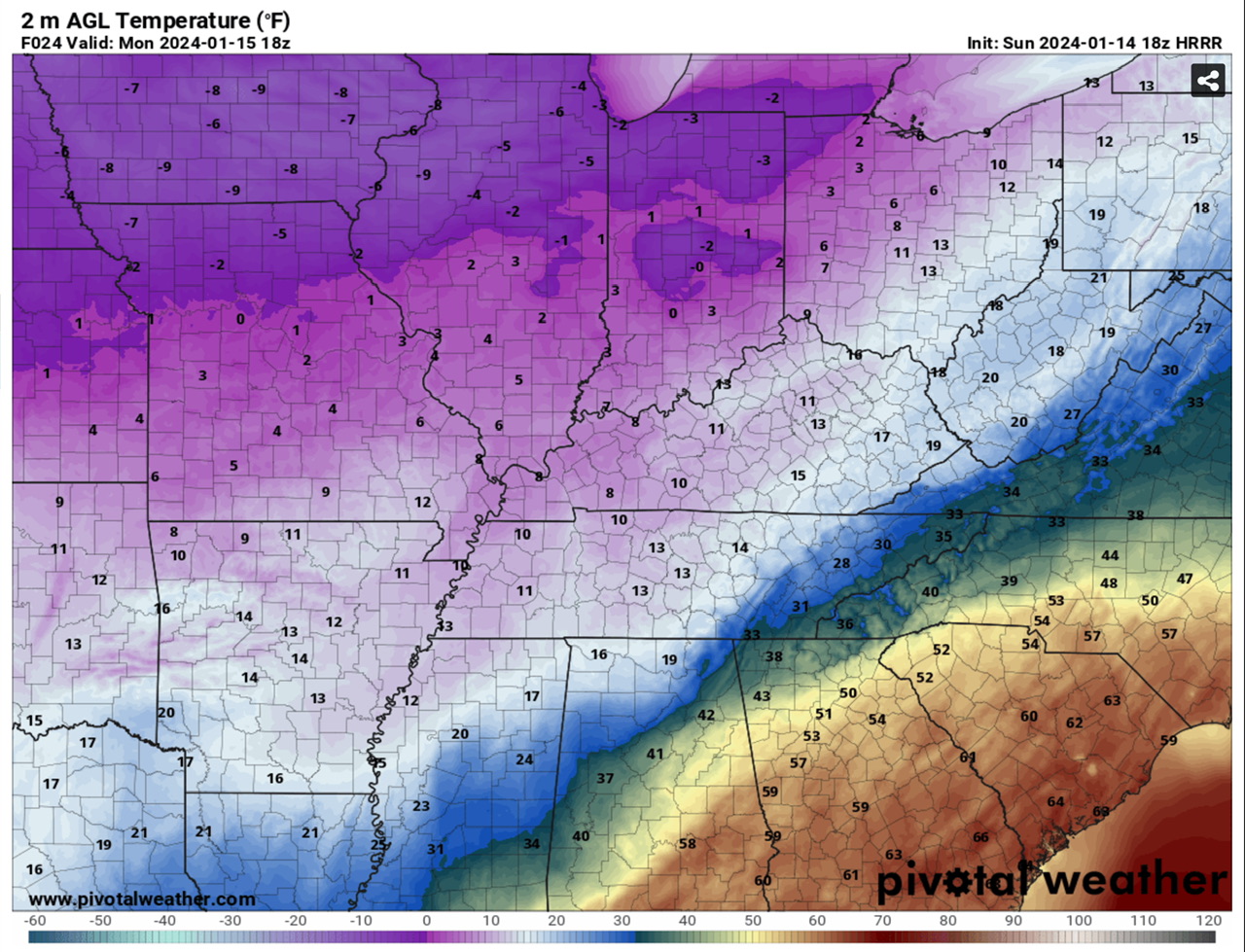
Very steady NW trend continuing on HRRR at 20z. Chattanooga is now above 32 by 9am tmrw and border counties of NE TN.
this is just... bad.
-
Here is the 12z hrrr vs the 19z hrrr. Notice the freezing line southern extent steadily trending north. Are we being reverse NAM'd in the East? Haha hate to say it but trends are not your friend in ETN
-
3 minutes ago, TellicoWx said:
NAM has an 80' deep warm nose (925-950)...unless that nose originated from Hades think it's overdoing the frz ra
I think it's pulling that up from the south and piling it against the apps. A completely reasonable scenario IF it's as amped as it shows.
The cold push really isn't doing much "pushing" it's pretty stagnant for the ETN area. Not to mention peak heating.
-
1 minute ago, John1122 said:
Even though it benefits me the most, I truly hope the NAM isn't right for everyone else's sake.
It sure is consistent isn't it? This last minute amped trend is no bueno for the valley east. I'm not too surprised but it's not fun to watch haha.
Absolutely rocks Middle TN though!!
-
Bright banding is always indicative of a phase change in the precipitation. It may not show on the ptype charts but the hrrr is mixing sleet/rain in for 3-5 hrs. It's not convection banding it's brighter returns hitting larger objects ie sleet/rain

-
2
-
-
Lots of mixing on hrrr for eastern counties. To be expected at this point.
the faster onset is probably not helping the cold push.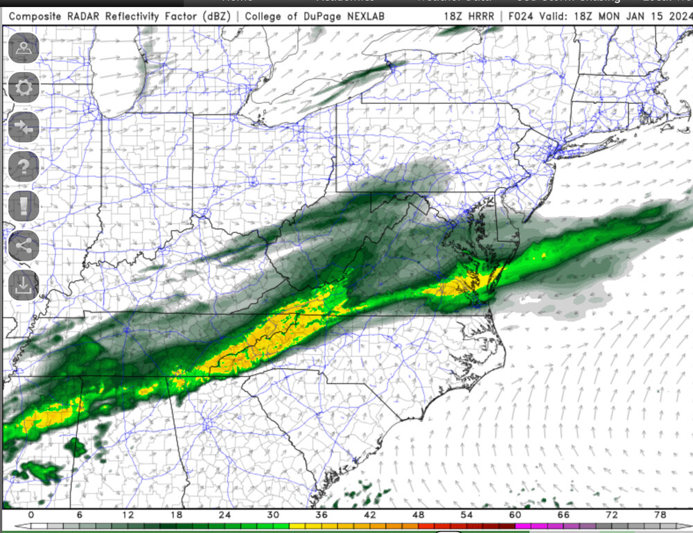
-
Hrrr is trending toward that little bend in the precip shield that was not kind to Eastern areas on other models.
-
Yes part of the mixing you see is lack of moisture. It's a very valid concern still though.
i have doubted the Ptype maps before and said "but soundings support snow!" You know what I ended up with? Not snow lol.
-
41 minutes ago, Uncle Nasty said:
I don't mean to sound like a Debbie downer, but I've seen this set-up over the years bring major disappointment to snowlovers in Chattanooga. I'm cautiously optimistic we are on the cold side of the precip, but I can't help but be concerned about the lurking warm air nearby. What I'm seeing is Chattanooga (the southern area bordering Georgia) will be in the 34°-36° temperature range tomorrow for a good portion of the day. Atlanta might even reach 50°. We aren't that far from Atlanta. I would really hate to see the Arctic cold air stall just to our north and west and keep us mainly in a mixed bag of precip until the changeover.
All the pros on here, please correct me if I'm wrong, but I really do see that as a HUGE concern for Chattanooga.
Sent from my SM-S916U using Tapatalk
It is a valid concern. I'm in the same boat here 5 miles from the NC/TN border. The hrrr is ticking north in the mid range now.
I would expect mixing for you and myself Monday during peak heating atleast.

January 15th-17th 2024 Arctic Blast/Snow Event
in Tennessee Valley
Posted
Still 32.5 90% slushy snow some rain now. 400ft below me it's almost all rain. Will be interesting to see how the evening goes. If we can get back down below 32 could add an inch onto the slushy inch I've got.