

fountainguy97
-
Posts
1,027 -
Joined
-
Last visited
Content Type
Profiles
Blogs
Forums
American Weather
Media Demo
Store
Gallery
Posts posted by fountainguy97
-
-
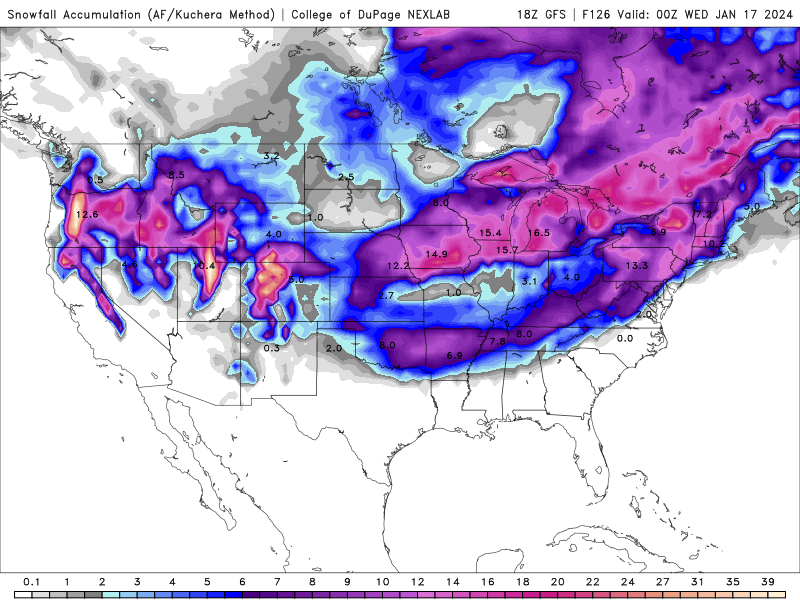
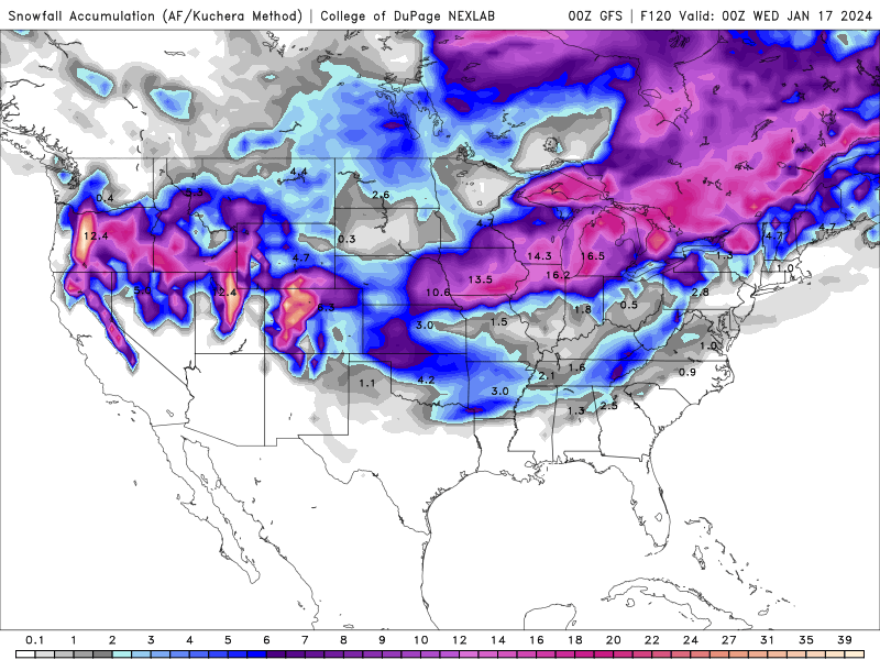
18z top 00z bottom
-
1 minute ago, Matthew70 said:
Icon now GFS leaning towards the Euro.
Oh yeah gfs took a monster shift to a whiff. Still ok for Eastern areas but writing is on the wall. Is this the classic case of models losing the storm 4-5 days out and it comes back 3-4 out? Who knows. But I'd not be expecting much for anyone at this point.
-
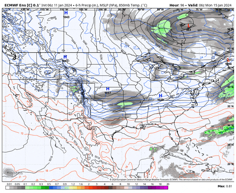
Yeah this is suppressed... almost no initial moisture.
-
Yeah hr 84 initial precip is flatter and much weaker and SE. this seems to be following the trend of a weaker OTS system.
-
2 minutes ago, Silas Lang said:
What are the implications of this?
Not fully sure but I believe it is causing a slightly flatter initial wave.
-
Hr 54 on gfs that little pacific vort max keeps slowing down each run.
-
 1
1
-
-
Yeah icon ends a little more positive tilt but pretty much same snowfall as 18z. Actually better for my backyard
-
1
-
-
13 minutes ago, Holston_River_Rambler said:
At least we still have one of the Euro machine learning models:
AI is the new DGEX
-
3
-
-
IMO that's an ok run. Little bit of an overtrend and then we tick back in the mid-range. Happens often.
-
1
-
-
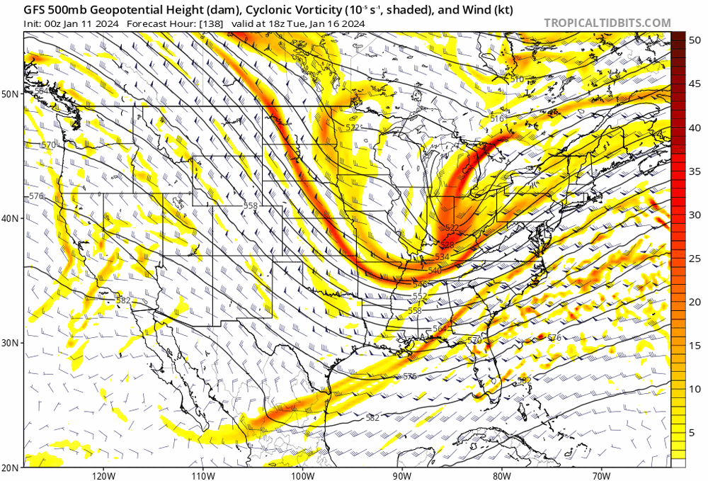
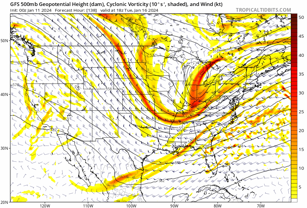
Hr 66 not much change with the ribbon of vort energy but the west coast vort max has trended much further east this run.
-
Looking at the 12z suite at hr 84 it's clear the cmc and icon are holding/digging the trailing piece significantly more than the rest. I'd say they are the outlier right now idk if that's a bias but all others are really pretty close.
-
1
-
-
11 minutes ago, TellicoWx said:
Now need to get this inside the 72-84hr window...models are known to have an almost mini truncation point during that time. If any big move is going to happen that's the window I look at.
Yeah this is always the "no man's land" of winter storms. We have a somewhat consistent storm scenario on all OPs now. But there is this 2 days of "Who knows where this goes" before we really begin to lock in. Next 2-3 days will be long ones haha
-
3
-
-
7 minutes ago, Carvers Gap said:
The 12z UKMET has come well south of 0z. Trends on operationals matter at this stage.
Yep much improved. All I want to see is 12z euro. Great trends toward a pretty consistent storm setup. Now that we are slowly coming inside 5 days we will have to watch for those smaller "tick" trends.
-
3
-
-
Gefs really coming on board.
-
1
-
 1
1
-
-
2 minutes ago, Carvers Gap said:
I can find us a way. LOL. Run that SLP from New Orleans to Norfolk. Word on the street is that the AI model has that track - but it is alway wrong! LOL.
That would do it lol. This will be a breath of fresh air considering ground will be fully frozen at the start. We won't lose a single flake to melt assuming CMC is over doing it. Not to mention we won't break 32 for an entire 7 days. Even 2-3" of snow will stick around for days
-
2
-
-
1 minute ago, Stovepipe said:
12z GFS would shut the state down for a few days with the modeled temps.

What's absurd is the entire state is pretty much below 32 starting this Sunday and going through the next Sunday. And most of that is WAY below 32
-
2
-
-
I feel like the gfs was about the best case. Seems any more amped it'll be easy to have mixing issues. I don't see a way to get a ton more moisture out of this.
-
1
-
-
This is a super long event. Snow breaking out with the Arctic front by hr 90 on gfs but trailing piece doesn't pull away until hour 144
-
3
-
-
27 minutes ago, Holston_River_Rambler said:
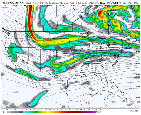
6z Euro control was a lot slower and deeper with the trailing wave. It almost looked like it was trying for a suppressed Miller A:
Wow that was a major East coast Storm there. 12z will be interesting! Need it to turn that corner even faster to get precip back our way but that's a great look 5-6 days out.
i feel like we have been saying 6 days out for 4 days now lol.
-
1
-
-
GFS trending toward EURO. All I care about right now is what the euro does. If we can just increase QPF even .15-.2 across the region you're talking about widespread 7-8"
the ceiling is so high with this one. GFS is snow in the single digits. Ratios will be upwards of 20:1
-
6
-
-
Moved to storm thread.
-
Models have definitely come together for an overall idea. Trends will still happen from here. Euro still the best for snow which makes you pretty confident. Remember we are tracking .1's of qpf 5-6 days out.
The euro has the best coastal development yet but it still doesn't throw much qpf back across ETN. It doesn't really consolidate the energy but just strings it out.
-
17 minutes ago, Silas Lang said:
Fair enough. I am the opposite. I don't follow basketball much, aside from the odd game, but in football, I would much rather be competitive and relevant, even if we don't always win the big ones. For me it's nice going into games knowing we at least stand a chance. Heupel has been great at UT. Excited for the Nico era!
I'm just angry right now lol. Nico has a MUCH higher ceiling than Milton ever did. We should be competing at a high level again next season. 12 team playoff actually makes post season interesting.
-
Truthfully I'd rather TN just be irrelevant. Both in football and basketball losing every game that matters. SMH let's just suck again to not waste my time.
January 15th-17th 2024 Arctic Blast/Snow Event
in Tennessee Valley
Posted
Meanwhile the cmc is even further inland and rain for plateau eastward lol. Not over yet but yeah trends today have been rough.