

fountainguy97
-
Posts
1,027 -
Joined
-
Last visited
Content Type
Profiles
Blogs
Forums
American Weather
Media Demo
Store
Gallery
Posts posted by fountainguy97
-
-
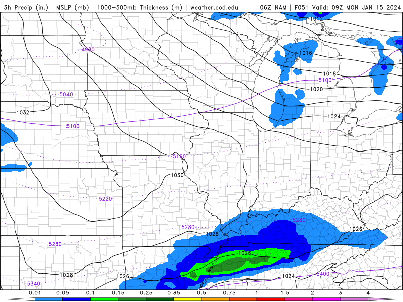
I love this precip map on COD. 06zfirst
-
 1
1
-
-
NAM at 42 is still going to be north but it has ticked SE and weaker with precip.
-
1
-
-
The NAM loves to amp stuff too hard in the mid-long range. It's pretty bad outside 48hrs. RGEM can do it too on occasion but is typically more reliable.
Globals have definitely ticked flatter since 12z yesterday. I full expect the NAM to cave at some point. RGEM is a beauty and is right in line with most overnight globals
All of the energy will be coming onshore by 00z tonight so I'll be treating 00z as the first run to take seriously for amounts and locations.
-
2
-
-
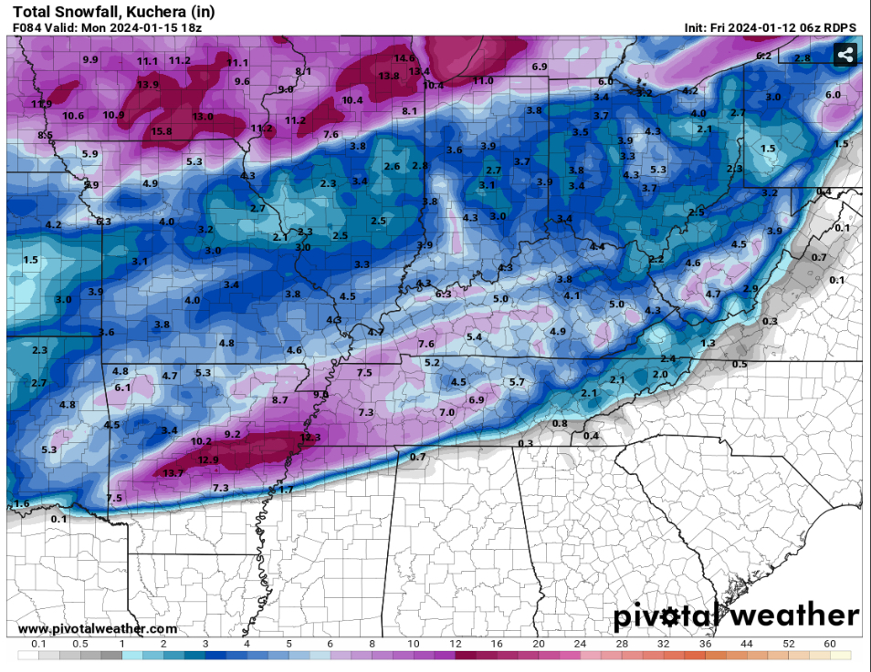
Overall the 00z models have shifted away from the larger overrunning shield and to a much more focused and thin overrunning band. In general most of them did sag southward some.
00z really trended away from the widespread TN event and to a more focused band of snow.
Probably see alot of wobble back and forth with the location of the boundary and overrunning. It's a very touchy system. This one will be stressful up until go time.
-
1
-
-
4 minutes ago, Uncle Nasty said:
I'm resigned to the fact that Chattanooga is mostly cursed in these setups. I honestly can't remember a good statewide Tennessee snow where Chattanooga managed more than an inch or so. It's tough watching areas within 30-50 miles of our area getting plastered, and we are hoping to manage a cartop dusting up to 1". It also happens here often when Georgia gets a good 3-6" snow, and we are just too far north by 30 miles or so and get nothing. That's just the way it is around here.
Even the system rolling in on Monday looks to have most of our qpf used up as a cold rain before switching over, if it does at all.
I'm still pulling for everyone else to get a good thumping and some miracle 50 mile jog south of colder air and decent qpf for our area. We need a surprise.
Sent from my SM-S916U using Tapatalk
Feel your pain with this one. I'll be in the same boat. 30hours of light drizzle while 30miles west it's 8" of powder.
we hug the RGEM until the end! Haha still hope for us far eastern folks!
-
2
-
-
1 hour ago, PowellVolz said:
I had no idea I followed you on twitter
.What's your Twitter handle?
-
2
-
-
10 minutes ago, Dsty2001 said:
I keep noticing Greene and cocke counties keep getting the short end of the stick on these runs. Possible downsloping issues or what? Would certainly be strange for there to be more snow points south and west of us to get several inches and then a sharp cutoff but stranger things have happened
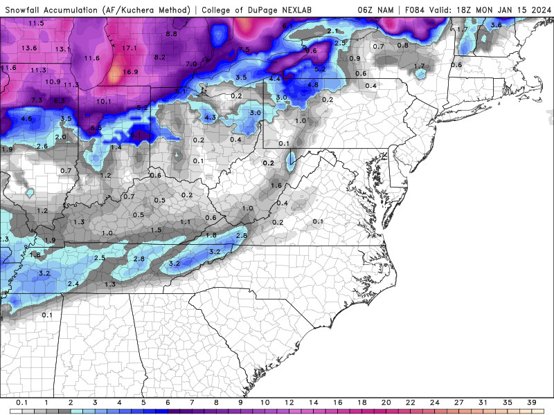
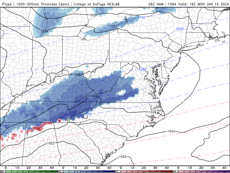
The icon is rain for border counties including your area. The NAM just has no precip for us. And the RGEM also has rain for border counties.
Too amp'ed. My county is even worse. Unfortunately it's a very likely outcome with every single model showing that. Still some time to move around though. -
The 18z NAM is starting the party off right with a nice NW trend lol. Here we go.
-
1
-
-
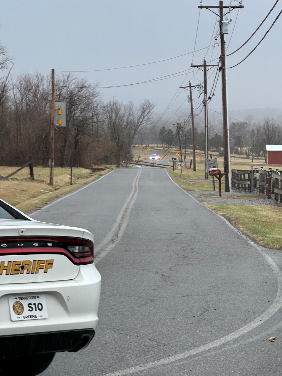
Here you go. Hard to see but leaves and small debris are ripping past. This is my new record for wind! Previous was 74mph during hurricane Irene in Eastern, NC. Station recorded 83 while I was recording.
-
7
-
 3
3
-
-
1 hour ago, Math/Met said:
That's the best area. I usually go to the church parking lot that is next to the Camp Creek Memorial. It is next to the school. I like that spot because it gets me away from trees and power lines.
Good call on the power lines lol. I had just drove down this road to get into camp creek.

ill splice my vids together and put it on YouTube this evening.
Back home we have trees down everywhere in Erwin. Never seen anything like this here. Wind was funneled perfectly down Rock Creek Rd and just blasted us.-
4
-
-
38 minutes ago, Math/Met said:
That's the best area. I usually go to the church parking lot that is next to the Camp Creek Memorial. It is next to the school. I like that spot because it gets me away from trees and power lines.
Definitely gusting into hurricane range. Tough to stand. It's cold. The rain hurts lol
-
3
-
-
5 minutes ago, Math/Met said:
Keep us posted. Have you been there before?
I have been to camp creek but not for wind event. I was going to head to the elementary school.
-
1
-
-
Wind is nearing extreme here. Trees down. Power out. I'm heading to camp creek which is gusting toward 90! Only 40min drive.
-
2
-
 1
1
-
-
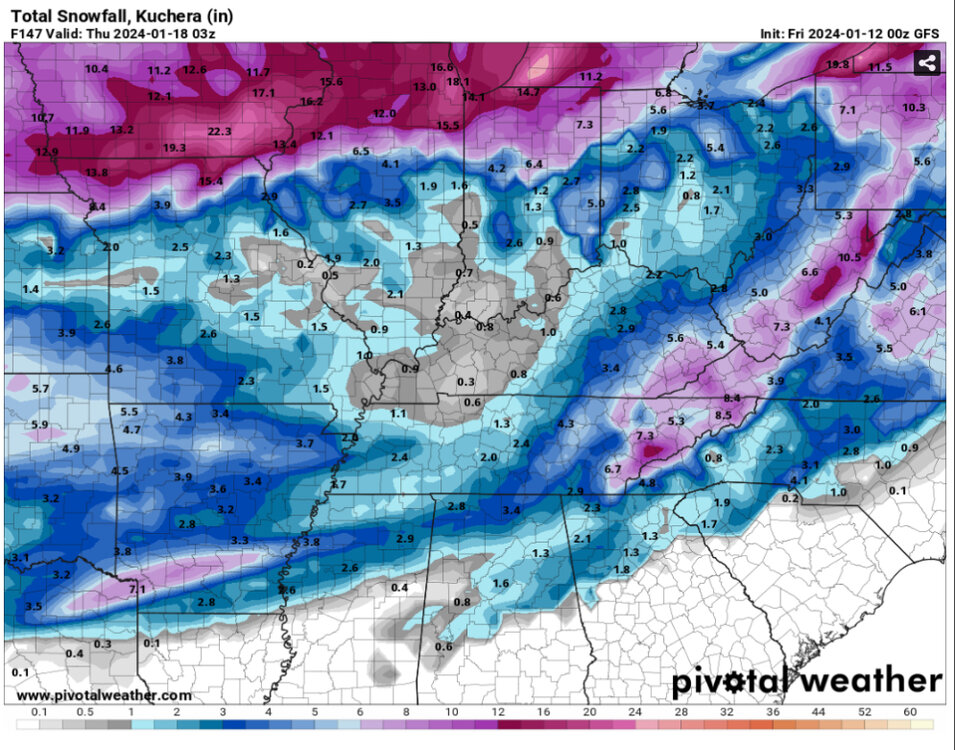
crappy run for me on gfs. That over-running pivots north which is my fear for NETN. but man it crushes the rest of the state!
-
3 minutes ago, Carvers Gap said:
And it is still going in eastern areas, correct?
kind of but no not really. The front doesnt really push far enough. the line of purple on the snow map is pretty much where the precip sets up.
Sharp cutoff. for Mountains and NE TN.
But this run is actually about 50 miles further SE than 6z.
-
Yeah I was about to say the NAM is still light compared to 06z rgem
-
Currently the EURO is just a massive outlier. At 500mb it's just not even close to anything else.
the snow map is even more stark. Every model has a great overrunning setup for TN at hr 84. And then the euro is just nothing.
-
3
-
-
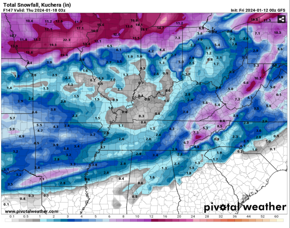
We are starting to enter what I call the "tick trend" phase. Gone are the monster shifts run-to-run. Now we should see steady slower trends.
At some point we will see a "snap" run where all models converge to a uniform solution. That typically happens in the runs just before or as the energy comes onshore. That happens with this system Saturday. So look for someone to cave today/tmrw. (I think it will be the euro as it's a classic case of an "overtrend" and it will correct back. Not to mention the shift it just made toward gfs at 06.)
-
7
-
-
4 minutes ago, Met1985 said:
The NAM gas been pretty off recently. Something I've noticed is that it's been under forecasting precipitation values in recent weeks by a couple inches...
yeah it is often too dry. RGEM is juicy.
-
1
-
-
NAM looks fun. Very much inline with 00z gfs.
-
Man the gfs is just absurd for cold. 9+ days most of the state below freezing starting Sunday. Those with snow cover have 5+ nights in the single digits or 0.
my wallet is thin as it is lol. Heat bills are going to be crazy.
-
2
-
-
Some of these GEFS members are going to be monsters for ETN
-
2
-
-
Still turned out pretty good for ETN. Not often you see the valley get the goods like this.
-
1
-
1
-
-
Honestly that's a good low in the Gulf for ETN. The problem is we don't go negative tilt. The whole trough just slides east instead of pivoting. If it had of gone negative tilt it would have buried the mountains.
the problem is the state-wide snow has gone poof today

-
2
-
January 15th-17th 2024 Arctic Blast/Snow Event
in Tennessee Valley
Posted
Yep it's a fine line. Not feeling good for me. I'm basically as far east as you can get haha this is one of the times the mountains won't help me. Hope I can at least get an inch just so I'm not a full shutout.
Hope you guys and the valley can cash in! Seems like Knoxville and south have been left out a lot in recent winters.