

fountainguy97
-
Posts
1,112 -
Joined
-
Last visited
Content Type
Profiles
Blogs
Forums
American Weather
Media Demo
Store
Gallery
Posts posted by fountainguy97
-
-
Yeah I was about to say the NAM is still light compared to 06z rgem
-
Currently the EURO is just a massive outlier. At 500mb it's just not even close to anything else.
the snow map is even more stark. Every model has a great overrunning setup for TN at hr 84. And then the euro is just nothing.
-
 3
3
-
-
We are starting to enter what I call the "tick trend" phase. Gone are the monster shifts run-to-run. Now we should see steady slower trends.
At some point we will see a "snap" run where all models converge to a uniform solution. That typically happens in the runs just before or as the energy comes onshore. That happens with this system Saturday. So look for someone to cave today/tmrw. (I think it will be the euro as it's a classic case of an "overtrend" and it will correct back. Not to mention the shift it just made toward gfs at 06.)
-
7
-
-
4 minutes ago, Met1985 said:
The NAM gas been pretty off recently. Something I've noticed is that it's been under forecasting precipitation values in recent weeks by a couple inches...
yeah it is often too dry. RGEM is juicy.
-
1
-
-
NAM looks fun. Very much inline with 00z gfs.
-
Man the gfs is just absurd for cold. 9+ days most of the state below freezing starting Sunday. Those with snow cover have 5+ nights in the single digits or 0.
my wallet is thin as it is lol. Heat bills are going to be crazy.
-
2
-
-
Some of these GEFS members are going to be monsters for ETN
-
2
-
-
Still turned out pretty good for ETN. Not often you see the valley get the goods like this.
-
1
-
 1
1
-
-
Honestly that's a good low in the Gulf for ETN. The problem is we don't go negative tilt. The whole trough just slides east instead of pivoting. If it had of gone negative tilt it would have buried the mountains.
the problem is the state-wide snow has gone poof today

-
2
-
-
1 minute ago, Matthew70 said:
Euro is King & always will be. This is a no go. Very Cold & dry. School kids & all of us will hate next week. Useless cold.
Meanwhile the cmc is even further inland and rain for plateau eastward lol. Not over yet but yeah trends today have been rough.
-
18z top 00z bottom
-
1 minute ago, Matthew70 said:
Icon now GFS leaning towards the Euro.
Oh yeah gfs took a monster shift to a whiff. Still ok for Eastern areas but writing is on the wall. Is this the classic case of models losing the storm 4-5 days out and it comes back 3-4 out? Who knows. But I'd not be expecting much for anyone at this point.
-
Yeah this is suppressed... almost no initial moisture.
-
Yeah hr 84 initial precip is flatter and much weaker and SE. this seems to be following the trend of a weaker OTS system.
-
2 minutes ago, Silas Lang said:
What are the implications of this?
Not fully sure but I believe it is causing a slightly flatter initial wave.
-
Hr 54 on gfs that little pacific vort max keeps slowing down each run.
-
1
-
-
Yeah icon ends a little more positive tilt but pretty much same snowfall as 18z. Actually better for my backyard
-
1
-
-
13 minutes ago, Holston_River_Rambler said:
At least we still have one of the Euro machine learning models:
AI is the new DGEX
-
3
-
-
IMO that's an ok run. Little bit of an overtrend and then we tick back in the mid-range. Happens often.
-
1
-
-
Hr 66 not much change with the ribbon of vort energy but the west coast vort max has trended much further east this run.
-
Looking at the 12z suite at hr 84 it's clear the cmc and icon are holding/digging the trailing piece significantly more than the rest. I'd say they are the outlier right now idk if that's a bias but all others are really pretty close.
-
1
-
-
11 minutes ago, TellicoWx said:
Now need to get this inside the 72-84hr window...models are known to have an almost mini truncation point during that time. If any big move is going to happen that's the window I look at.
Yeah this is always the "no man's land" of winter storms. We have a somewhat consistent storm scenario on all OPs now. But there is this 2 days of "Who knows where this goes" before we really begin to lock in. Next 2-3 days will be long ones haha
-
3
-
-
7 minutes ago, Carvers Gap said:
The 12z UKMET has come well south of 0z. Trends on operationals matter at this stage.
Yep much improved. All I want to see is 12z euro. Great trends toward a pretty consistent storm setup. Now that we are slowly coming inside 5 days we will have to watch for those smaller "tick" trends.
-
3
-
-
Gefs really coming on board.
-
1
-
 1
1
-
January 15th-17th 2024 Arctic Blast/Snow Event
in Tennessee Valley
Posted
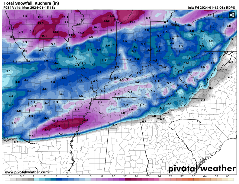
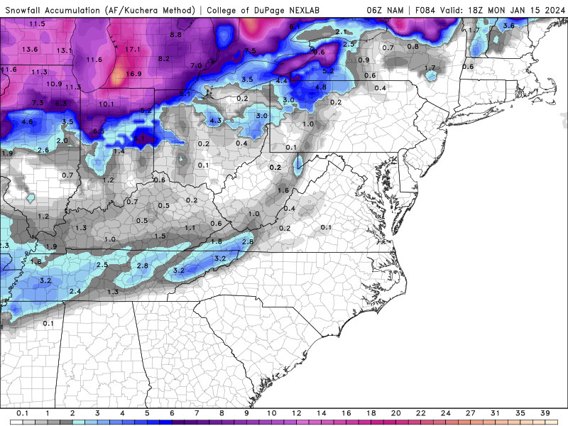
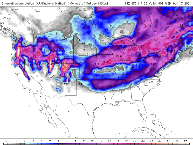
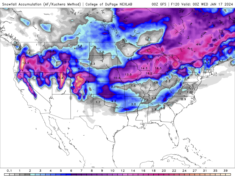
kind of but no not really. The front doesnt really push far enough. the line of purple on the snow map is pretty much where the precip sets up.
Sharp cutoff. for Mountains and NE TN.
But this run is actually about 50 miles further SE than 6z.