

fountainguy97
-
Posts
1,029 -
Joined
-
Last visited
Content Type
Profiles
Blogs
Forums
American Weather
Media Demo
Store
Gallery
Posts posted by fountainguy97
-
-
Man going to be an unusual day tomorrow for the middle of summer. Won't feel like it tomorrow. PWATs approaching 2". Probably going to be some flooding in the mountains of TN and NC if the 2-3+ inches materialize. The firehouse is already lined up.

-
 3
3
-
-
Peaked at 89.1 so far today. Have yet to hit 90 this year but I think we will do it this week. I won't be surprised if this week is the "peak" of our summers heat. Can't complain at all about the year we have had so far. A welcome relief compared to the last few Niña springs and summers.
The gears of fall are slowly beginning to turn up north. August will be hot but my favorite time of year is just around the corner! This time of year is when I always start rummaging through old winter event threads and wishing for colder days.
-
1
-
-
Checking in. It's hot. Is it December yet?
-
 3
3
-
-
Well with winter behind us here is my summary. 4 events behind normal. 11" behind average of the last 4 winters. (2019-2023 average)

-
3
-
 2
2
-
-
2 hours ago, nrgjeff said:
Fountain beat me to it. Not too upset to see the system vanish days 5-6. Note that WPC still has QPF those days.
I'd be happy to see the system show up again, without a mega-cut knuckle ball. Carvers STL captures that idea, lol!Never take anything off the table in the Southeast.
12Z Euro update. Nah, I'll tell you what's gonna happen. Spoiled NC whiners will get one on the coast. Is that even worse than the STL cut?
Honestly I don't think many anyone East of I-85 have much hope. Even the runs that favor them it's all a cold rain.
Your'e going to want to have atleast a bit of elevation for this one.
I'm indifferent abt it. It's one of the best looks of the winter for snow for the SE. But it's March and not early March. Temps will be a problem if we even get the precip.
This setup in January would be mouthwatering.

-
5
-
-
Models have flattened out the wave associated with next weeks storm. Probably right where we want it at this range. It would be fitting for the last threat to be suppressed though lol
-
4
-
 1
1
-
-
Significant uptick in GEFS members with this system.. CMC is close. This one is getting interesting. Sitting on the NW edge of this is exactly where we want to be.
-
3
-
-
2 minutes ago, Carvers Gap said:
Good look and still to the SE. We take.
This is a beautiful setup for the spine of the Apps. Big dog potential. Probably one of the best looks of the winter inside 180. Would like to see some more ensemble support though at this range.
-
2
-
-
15 minutes ago, Carvers Gap said:
Re: Tuesday system....The odd thing about the GFS...it spots systems from way out...then trends them sharply westward. The Euro and CMC have been 24-36 hours behind its trends. It has taken the Euro to school during Feb. Oddly, the Euro has had a recent progressive bias recently. Right now I prefer the GFS at all ranges. We are still at the point for next Tuesday where the operational is still pretty much a single member of the ensemble. 48 more hours and then we can talk seriously about it. I don’t have high confidence in any model seven days out...to the good or bad. As Jeff noted yesterday...there is one idea that the storm gets suppressed and another that comes north into a marginal air mass. To me, the only differences in tracks of the 0z Euro and 6z GFS was precip type. But again, as new data is inputed...those solutions will most certainly change.
To be fair to the GFS the EURO is very similar at 00z. It just isnt as dynamic of a system so the cold isn't there. This weekend is 100% cold chasing moisture with no other model support. Early next week could be a legit threat but support is low right now which is actually how we want it at this range. I'd rather be missed to the south at this stage. That is something we haven't been able to say any this year.
-
2
-
-
I am highly skeptical of this weekend and next week. Gfs has almost no support and we know how that has gone this winter.
-
22 minutes ago, Runman292 said:
Something I found interesting in MRX'S AFD and the most recent day 1 outlook from the SPC is the wording "Winds may be strong enough to tear apart storms and keep them from becoming mature." Can anyone explain to me how that works?
Wind shear is necessary for long lived storms because it tilts the updrafts and downdrafts away from each other. Allowing them to be independent. Without shear the updraft and downdraft overlap and smother each other.
Too much shear (wind) can just rip them apart from each other. Basically decapitating any storm.
here is a brief NWS article about it.
https://www.weather.gov/ilx/swop-springtopicsThe hrrr doesn't have any signs of issues with shear for the main line today. Doesn't mean there won't be limiting factors though.
-
2
-
-
Definitely looking like a "legit" severe weather event for TN this Friday.
The usual low cape, high shear event as typical for early season. But with temps in the 70s and DPs in the 60s we should get some decent afternoon development.

-
1
-
-
I have a feeling we are going to have a massive kill-off of budding plants sometime soon... no way we don't have a solid cold shot before April.
-
1
-
-
80.6/53 today. An absolutely perfect afternoon.
-
3
-
-
34.7 and coming down good! Small flakes but can tell it's ramping up. Too bad this didn't happen at lunch. I've had .7 inches of rain since then.
-
2
-
-
35.8 with flakes mixing in. Not a shutout atleast lol.
to continue the conversation... winter has been extremely low here. I'm over 8" below normal and will likely end up a foot or more below normal. I was talking to a friend who lives back in Eastern NC and he says it's the worst winter he was ever tracked. Not a single storm to track all winter. Not even a hint of a threat. Even in shutouts we typical have atleast a potential system or two outside the mountains. This year? Not a single one besides this one.
rough.
-
3
-
-
Deform finally moving in but a toasty 39. Hoping to atleast see some flakes.
-
1
-
-
My guess is daytime timing has killed this. Tough day of 38-42 and rain ahead. Definitely puts a nice bookend to this winter lol.
man... stings.


-
1
-
1
-
-
Tick tick tick hrrr looking good.

final frame.

-
3
-
1
-
-
2 minutes ago, Holston_River_Rambler said:
I can't see us worrying about rates with all that lift over central MS heading our way. Maybe downsloping takes some away?
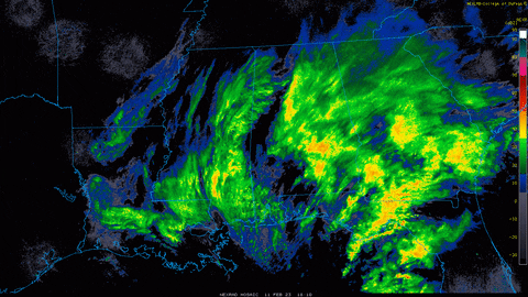
Some of that is bright banding but I don't think it all is. I think a lot of it is just hellacious lift.
I'm not really sure about why some models have a deform band of death vs others with barely showers. You would think we would have a monster deform pivoting through...
the Rgem made a big move for a heavier deform at 12z. Let's see it's 18z.
-
6
-
-
Can clearly see the difference between NAM and RGEM. For NE TN temps aren't the issue. It's rates.

-
3
-
-
16 hours ago, fountainguy97 said:
RAP, FV3 and EURO (hrrr too but just not quite there) have the deform band further east which allows rates to change NE TN to snow. They all have a good 6hr beat down on the tail end.
This feature is still 40hrs out. Plenty of wiggle room. We may not be done yet.
I've been watching trends on the pivoting deform band as a potential surprise and the 18z nam just delivered.
the euro camp from last night had the deform band pivoting further east allowing areas of NE TN to change to biscuits for the last 6 hrs of the event. Here is the nam trend. The hrrr has also ticked this way.


-
2
-
-
RAP, FV3 and EURO (hrrr too but just not quite there) have the deform band further east which allows rates to change NE TN to snow. They all have a good 6hr beat down on the tail end.
This feature is still 40hrs out. Plenty of wiggle room. We may not be done yet.
-
4
-
-
The fv3 came in like euro.
-
1
-
1
-


Spring/Summer Mid-Long Term Discussion
in Tennessee Valley
Posted
Over 2" already today. Easily heading to the largest single day total I've had here in the last 4 years.