

Kevin Reilly
-
Posts
2,154 -
Joined
-
Last visited
Content Type
Profiles
Blogs
Forums
American Weather
Media Demo
Store
Gallery
Posts posted by Kevin Reilly
-
-
This storm was amazing in NE Philadelphia where I lived Tabor Road and Adams Avenue off of Roosevelt Blvd picked up 22.7" with 8 foot drifts in the driveways between our row homes.
Yes, I was out in it loving it when I was 9 years old. I remember being out when the lightning flashed and heard the low rumble of thunder with 2-4" snowfall rates an hour complete with grauple. There were multiple flashes of lightning and thunder during that storm very dynamic. My trusted weather forecasters this night was Jim O'Brien and Herb Clark.
1983 was a sad year as this storm would be the last big one that Jim would cover!! God Bless Jim O'Brien and his family he no doubt fueled my love and passion for the weather!
-
 1
1
-
-
2 hours ago, Wentzadelphia said:


Wow so the Blizzard of 83 was only a 1004 mb low??? With all that dynamics.
-
Media Delaware County Total 24.6"
-
now very light snow in Media 32
-
48 minutes ago, KamuSnow said:
Getting some snow flakes here - woohoo! Had to step away from the kettle fire to be sure they weren't ashes, lol.
eta - nothing at the moment, gotta wait for that gap on the returns to fill in/move east.
Well gotta check since we live along the Baltimore Pike Corridor: Nothing yet here in Media Delaware County Cloudy 32 humidity humidity 61% dew point 22 very light east wind.
-
7 hours ago, RedSky said:
The Canada puts up a 20 spot on Philly next week, fwiw which is absolutely nothing
No Way!! Gotta be Sleet!
-
14 minutes ago, WinterWxLuvr said:
HPC certainly doesn’t think the second wave will be south. When in doubt go with the pros.

I am from the northern Mid-Atlantic about 7 miles north of the PA/MD/DEL line but what I am seeing is the models bouncing a bit due to the boundary that the storm is going to ride along including a bit of push from the cold up north (confluence). Now I am in here often because the knowledgeable posters are awesome!! At some point though with the deep cold on the northern edges we are going to have to start talking about snow ratios. It has been mentioned a few times but up here on the border southern PA I am hoping for the .35 liquid with 18-22 degree temp to produce my 4-6" of snow+. I do have a feeling though that the end games bring things north it's been happening all year now. We shall see.
-
Here is your elevation report at the airport at 1:03 pm reported 0.7" so far meanwhile 10 miles away you got 5" go another 10 miles and you are sitting at 10".
Upper Darby Delaware County 0.8 Media, 5.6 I am sure you go out to Newtown Square and they are sitting 7-10"
Urban heat island effect.
-
I am looking at posted pictures from Southern Delaware County over towards the airport only have like coating to 1" on the grass the official report from the airport should be interesting coming up on 5" here in Media definitely got to my level of expectation probably end up with 5.0-5.7" or so.
Literally 2 miles away has like less than 2" elevation huge factor.
I sit at 345 feet the magic number is 400Feet ;plus gets 8-10" where the banding set up.
-
Just now, KamuSnow said:
Snowing heavily here again at the moment. Up to 3.5", temp. is 35F.
Heavy just began here too Kamu! Media just east of Granite Run the Baltimore Pike Corridor LOL
-
1 minute ago, bpjones595 said:
Maybe 1.5” so far in Chester heights. Roads aren’t even covered. Another bust down in delco...
.Umm coming up on 4" here in Media Delaware County my expectation was 5.2" so it's not too far off. Elevation is playing a role with this and the fact that temps are 33 now every hour here its been snowing.
Down in Ridley along the Delaware River I bet they haven less than you do out in Chester Heights.
Now with that said even here in Media paved surfaces are like 1.5-2" of snow but the grass area and old snow are at or just past 4" heavy band from Wilmington Delaware has Arrived and more coming up from the Southwest and west.
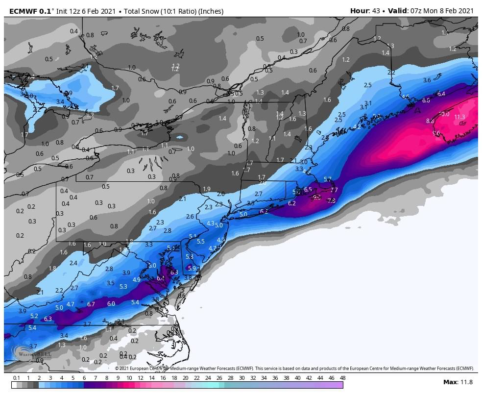
Think our totals here in the center of the County to about Newtown Square will likely fall 4-6" especially places like Newtown Square and Radnor highest elevations of Delaware County. Liken this to an early March storm where it was warm past two days with marginal temps at the surface. Banding also plays a huge role!
-
1 minute ago, ChescoWx said:
East Nantmeal Township - Chester County PA - 1030am obs
Snow really "slowed" down the past hour - ONLY 2.3" during the 930a-1030a hour following the 2.5" from 830-930a - total snow now 6.5"
Still S+ but temp up to 32.7 on VP and 32.0 on Tempest
Wow though 6.5" what were you expecting out there. This storm did come further North and west. Elevation here in Media sitting at 315 feet so think that hurts a bit we have like 3.5" I can imagine right along the Delaware River less.
-
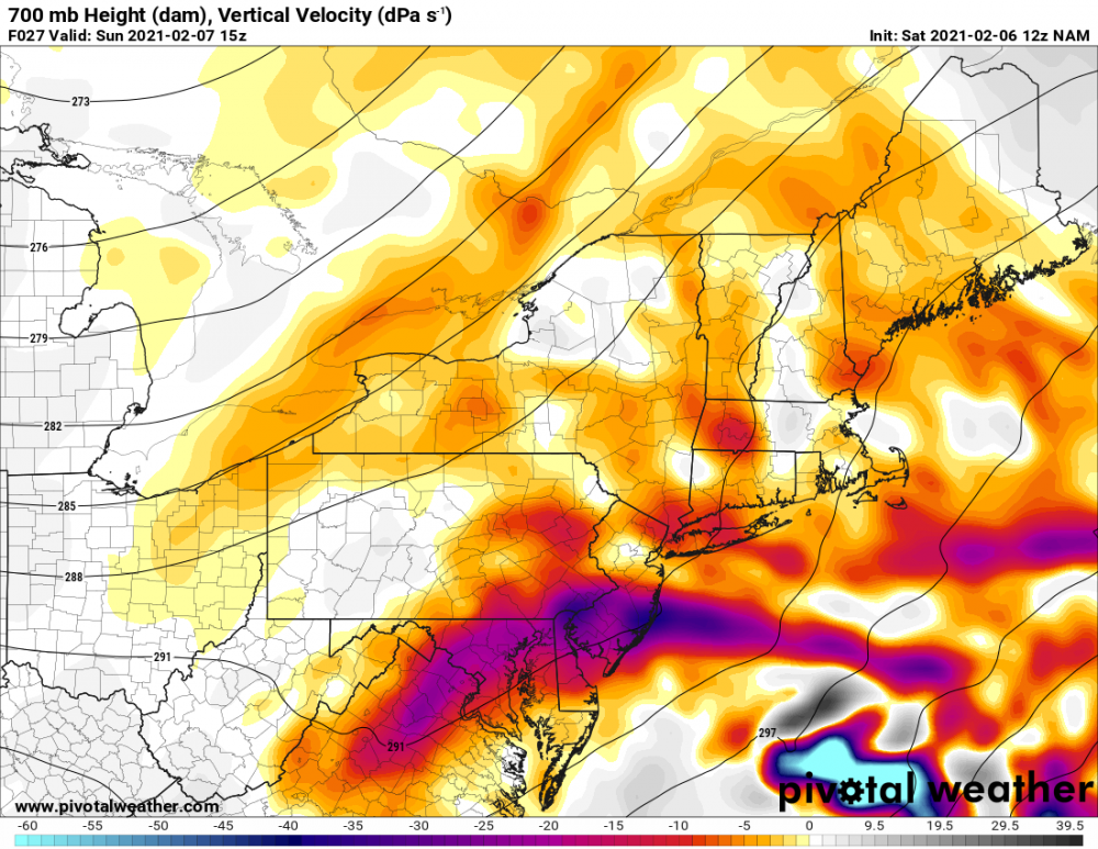
Looks like this will be going for a bit wow that's quite a band on the west sides of Baltimore and Washington DC moving NE.
-
Looks like just along 95 north west sitting pretty good right now rain issues coast to about 35-40 miles inland for now.
-
Just now, ChescoWx said:
Unfortunately I think where the heaviest banding is they may be just a bit north of freezing and may lose some accumulation to that....
Yep no doubt. looks like 34 and rain in Hammonton just 28 miles inland along the expressway. Looks like the rain snow line is straddling the 55 Corridor on the way to the shore there.
-
12 minutes ago, Ralph Wiggum said:
Best banding definitely East over NJ. Congrats @The Iceman and others in Central NJ! Should easily see 5" lollis those parts.

Some of that is Rain. Mullica Hill just switched over to snow right now. So southeast of 55 its all rain still. I am sure it is doing the work in cooling the column quickly though and all will switch over to snow.
-
1
-
-
Media Delaware County 33 heavy snow all surfaces caving fast flakes are huge here too.
-
3 minutes ago, JTA66 said:
Ch10 says Feb sun angle will be an issue tomorrow

Last minute cover in case snow rates are light and snow melts where it counts on paved surfaces
-
 1
1
-
-
Media Delaware County Partly cloudy 37 Dewpoint 24
my expectation is 5.3”
-
19 minutes ago, RedSky said:
Looks like a 3" storm with loli's of 4-5" just don't throw toasters at me
-
2
-
-
16 minutes ago, RedSky said:
Looks like a 3" storm with loli's of 4-5" just don't throw toasters at me

-
 1
1
-
-
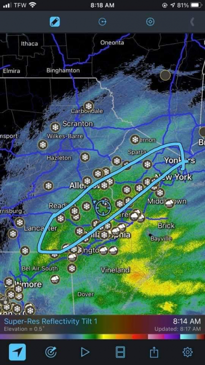
Very windy here in Media gusts were just shaking the house 35-40 at times SW winds too there’s your Jet.
-
5 minutes ago, Ralph Wiggum said:

Classic placement 95 NW that’s where I thought it would be yesterday and last night with the best lift.
-
There’s our lift centered on the higher elevations of Chester and Delaware Counties in the purple areas.


February 15-16 Event
in Philadelphia Region
Posted
Don’t look at the 0z gfs then.