

Kevin Reilly
-
Posts
2,154 -
Joined
-
Last visited
Content Type
Profiles
Blogs
Forums
American Weather
Media Demo
Store
Gallery
Posts posted by Kevin Reilly
-
-
10 minutes ago, Birds~69 said:
By far this is my concern. Thinking 3-4am start time?
36F
Gotta lay down snow prior to 8 am.
-
 1
1
-
-
13 minutes ago, Ralph Wiggum said:
I would also feel more comfy if this was night and not happening during the day with the marginal BL.
Yes especially for lower elevations Delaware River SE fall line elevations that are higher than 350 feet I’m okay with getting the 4-7” so long as banding is ongoing.
-
1
-
-
Well the overall theme with the exception of the gfs is a tick NW and some like this model a big tick NW the 12z Nam will be telling. We are just about game time down 2 with 24 seconds left and Doc Rivers calls time out and asks if Embiid is okay to go back in for one more play with his stiff back.

-
 1
1
-
-
1 hour ago, yoda said:
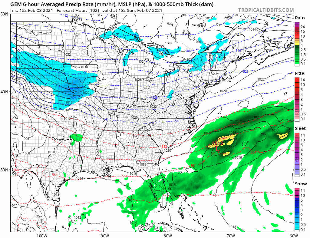
which results in below re snow accum changes on the 06z RGEM compared to the 00z RGEM

Pretty significant shift in the end game
-
2
-
-
1 minute ago, Wentzadelphia said:
Sounds about right. The rgem ticking was huge. I think the better totals will be just east of 95 though, but I guess climo argues otherwise. Regardless anyone complaining about even 3-4” a few days after a mecs and with another event in the day 6 vicinity is nuts. This is awesome! Let’s get some tsnow tomorrow
Well anyone that does get the TSnow gets over 6”
-
2 minutes ago, zenmsav6810 said:
Indeed she does look a bit underprepared! When in doubt do as the nws! I think her forecasting has improved over the last 10 years and this situation is fairly textbook for the met vetrans in the area. Probably a good call but could see this map getting amounts reduced and moved N & W.
Canadian agrees
-
10 minutes ago, Animal said:
First call
wilmingto de(city) 10 inches
my house - 11 inches
oxford,pa - 7 inchrs
pauls house - 8 incjes
phl - 10
New hope, pa - 13
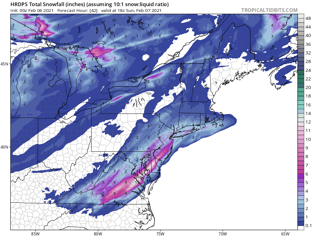
My call along I-95 4-7” with isolated 8” amounts includes Northern De NE Md Delaware County Chester County Montgomery County Berks County PHL to Trenton to Allentown. Highest amounts fall line about 20 miles west and NW of I-95
-
1
-
-
50 minutes ago, Ralph Wiggum said:
Borrowed from the Mid Atl sub, 18z euro is a nice hit and shows why even tho I think climo says I95 r/s line there is enough guidance still suggesting that central and southern NJ is very much still in the game:

Don’t forget Delaware too they have been screwed all year too
-
Light rain 36 here in Media 0.2” of slush on cars pretty much wiped away by rising temps and light rain it was a back and forth affair of light rain to snow to rain.
Maybe the 12z models can pull off a coup to significant snow for Sunday. I’ll go with the Ukie my model of choice since it’s been consistent along with the Euro.
As I speak back to snow here now with a bit of graupel 36
-
Well CMC was an improvement with 60 hours to go. Ukie has always pretty much had this storm and said it wasn’t dead that will be interesting to see.
The Euro run tonight is a biggie for me.
Either way 12z tomorrow this is getting closer to nailed down.
our last storm 60 hours out and closer in trended easily NE by 150 miles.

-
40 minutes ago, MJO812 said:
.thumb.png.38ab217558bbf93ecde314a838cdb931.png)
Wait those numbers are too high that’s gotta be sleet on the NAM lol
-
1
-
-
49 minutes ago, LeesburgWx said:
DT is woofing!
“details shortly and on the TWITTER page --- approx an 8 hours event starts in ne nc eastern VA BEFROE DAWN on Sunday FULL UPDATE shortly ...woof....”
He’s looking at the NAM
-
Building SE Atlantic Ridge pumping west it appears and changes out west. I think 12z starts the trend remember Euro on Monday showing 6-10”. I mean the GEFS shows rain for some showing the block is allowing the storm north and the SE ridge guiding it further NW.
-
2
-
-
1 minute ago, Birds~69 said:
That sucks:(
The really cool part of that storm was I listened to KYW all day while going coming in and going outside while Elliott Abrams kept upping the totals, it seemed like every hour or two. It was a cold/dry snow which added to the drifting. I think temps were in the mid teens or so....
I was living in NE Philadelphia and the winds were howling down the driveways between row homes. One side was completely bare of snow maybe an inch the other side 5-6 foot drifts. I was 9 years old so snow was up to my waist and the drifts in some cases over my head. I remember the thunder and lighting and also the graupel mixing in with the snow while we had the lighting and low rumbling thunder. I think the next day under the strong Feb 12th sun it made it into the upper 30s. Almost like the storm mixed out the arctic air and replaced it with modified Atlantic air.
Reason I say this last sentence because the air out there at 32 down here doesn’t feel Arctic anymore feels like modified Atlantic air that storm basically flipped every thing.
looking over the models looks like a bit of a war setting up medium long range with the Southeast Ridge and cold coming back from Canada.
Next two weeks could get interesting up and down the east coast with an awakening subtropical jet in play.
-
1
-
-
16 minutes ago, RedSky said:
Significant retreat of the "polar vortex" cold that was being shown for next week a couple days ago to normal cold, no complaints.
I wonder if that allows the southeast ridge to building sending out Souther miss Sunday back NW time will tell??
-
2
-
-
Steady snow falling in Media Delaware County 31 was 32
-
25 minutes ago, CAPE said:

Is that sleet hitting your umbrella!!
-
Media Delaware County 30f light snow snow and sleet total here 7.1” not too bad for a Miller B.
-
1
-
-
Media Delaware County moderate snow humidity 91% dew-point 27 wind NNE 16 gusts to 32 maybe an additional 1 inch since change over at 2:20 pm
-
Media Delaware County sleet 30 windy NE 23 gusts to 38. 3.9” snow sleet on the ground
-
1
-
-
Media Delaware County 30 light sleet a few flakes sun was just out winds NE gusts on weather station 37 mph. Losing the sun as I speak.
-
Media Delaware County the sun is making an appearance so there is some dry air mixing around.
-
I was asleep what did the 6z gfs show and the 6z Nam I saw Euro come in and went way north for us souls in SE Pa.


.png.b4318d3eed0e84fdee697cca8dadbcd3.png)
Feb 7th discussion/obs
in Philadelphia Region
Posted
Looks good to me!