

Kevin Reilly
-
Posts
2,947 -
Joined
-
Last visited
Content Type
Profiles
Blogs
Forums
American Weather
Media Demo
Store
Gallery
Posts posted by Kevin Reilly
-
-
3 minutes ago, WxUSAF said:
Yeah, freezing level is like 950mb in that deform band. It’s low, but also not right at the surface. So I think it would be pouring slush bombs at 34 if it happened like that. But it “should” be a 30-32F pasting.
Warm air trapped at the surface, many many cloudy days with fog at night, and very high humidity levels, you just can't get rid of the warmth even with a great set up. Tracking a snowstorm in our area is like predicting a hurricane strike on the Mid Atlantic Coast.
-
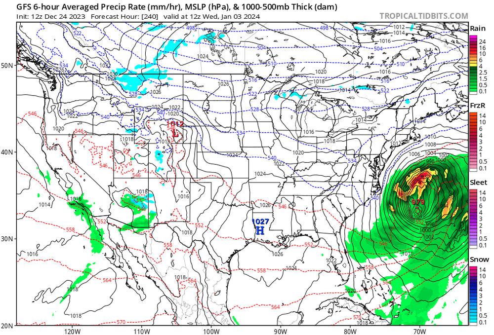
29 minutes ago, psuhoffman said:
I don’t agree with the analysis based solely on the surface track. Details matter.
The storm on the 6z gfs is tucked in tight but it’s coming at us from a southerly trajectory and it’s bombing and vertically stacked to 500mb by the time it tucks in close to DC.

Notice the precip is wrapped up tight to the surface low. There are examples of that track producing nice snows for us. Yea it probably should mix at the height but with a vertically stacked system wound up like that as soon as the low is east of our longitude it should flip in the deform band.
The track argument is really silly if you pull back and don’t focus on our own yard. How this frame isn’t conclusive and alarming is beyond me.

What’s track have to do with it? Even if you cling to the “it tracks to close for DC” its rain the way to the NW fringe of precip in the deform except for high elevations which mitigates the boundary layer.
Frankly that frame is absolutely terrifying to me. Were no longer a day into the pattern by then. We’ve had an NW flow into the eastern US for a week by then to establish a colder regime. Everything went 100% perfect for places a bit NW of DC (even DC should get a decent snow there) and it’s just rain.
Common theme no cold high up north.
-
 2
2
-
-
1 hour ago, Terpeast said:
This morning’s ensembles show something on Jan 4-6, something coming off the gulf with cold-enough temps. Still a long ways away, lets see if that potential holds.
Btw, Merry Christmas to those who celebrate! Happy Holidays all!
Anytime I hear Gulf and cold enough air it makes me happy! I will drink to that!
-
 5
5
-
-
1 hour ago, psuhoffman said:
Pattern analogs are useless right now. They’re spitting out some incredibly snowy periods (1996,2010) and some years that had almost no snow (2002, 1981). Subtle differences can tilt this either way.
I will take 1996 and 2010 for $1,000 Alex!
-
 2
2
-
-
2 hours ago, MDScienceTeacher said:
Right.. I dont know if anyone remembers this but the weather channel used to have a segment called "A look ahead" where they would show the jet stream pattern up to 7-10 days in the future. It was a great segment and they used it to warn people ahead of time for snow storm potential. That was probably my earliest memories of following weather models.
I am sure that segment would do very well today LOL. I do remember that always gave me hope in times of despair when it came to snow.
-
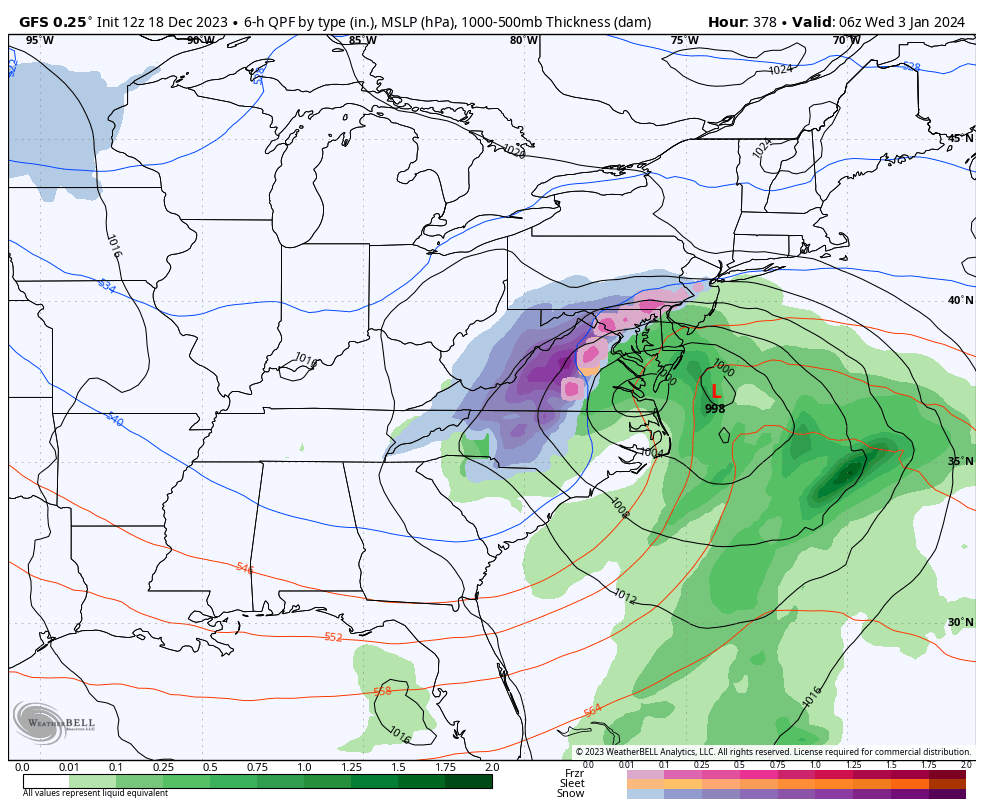
37 minutes ago, Chris78 said:
18z tries for January 4th/5th.
A little to warm though.
LOL did you see the 12z GFS the same storm was 972 275 miles out and on January 3rd. As I said it will come west it did now split the difference in 12z GFS and 18z GFS and BOOM!
-
1
-
-
1 minute ago, Blizzard of 93 said:
Here is a snapshot of just how undecided things are even at day 9 on the 12z Op runs…
Long way to go even for even the first few days of the year to be decided.


If you split the difference from the 12z GFS and the Euro we get hammered with snow!
-
1
-
-
2 minutes ago, WinterWxLuvr said:
I’m 100% certain things are getting ready to get fun
I can't disagree starting with that storm being further west on January 3rd. We look for the correction west.
-
I am not buying this on January 3rd, 2024, this is our storm.
I think that is further west. I am just thinking back to runs from last week when this was closer to the coast too. I think the GFS is beginning to correct this look further west as a northern stream system tugs it back to the east coast.
I am interested in this storm!
-
1 minute ago, Scraff said:
How the frick is it not snowing next Saturday morning with the 540 line in southern Georgia? Come on! Seriously? Fine—I’ll consider a hybrid, but not going full electric...yet.

Warm air trapped at the lower levels and warm air seeping in off the Atlantic at 2,000-5,000 feet?
-
12 minutes ago, ChescoWx said:Merry Christmas Eve to all!! We picked up 0.05" of rain early this AM but with temps well above freezing no issues. Christmas Day looks great for travel with temps well into the 40's across the county and partly sunny skies. No freezing temps at all across the area until at the earliest Friday AM. Rain moves in late on Tuesday evening and lasts into Wednesday night. We then have a change in the pattern to much chillier air which looks to last right into the first part of the New Year. There will also be some opportunities for wintry weather as we head toward the 1st weekend of 2024.Records for Christmas Eve: High 68.5 (2015) / Low 2 below zero (1980) / Rain 1.63" (1986) / Snow 20.0" (1966) which was the snowstorm with frequent thunder and lightning accompanying the heavy snow.

0.02" of rain in central Delaware County Mostly Cloudy currently a few breaks of snow here and there 48 degrees currently. We will be moving into the lower 50's should we see any sun today and certainly into the 50's tomorrow. The long-range forecast beyond January 1st shows some hope for cold and snow, but the annual push it back pushes it back clearly is at work here remember our days are now getting longer. Enjoy Christmas!
-
1
-
-
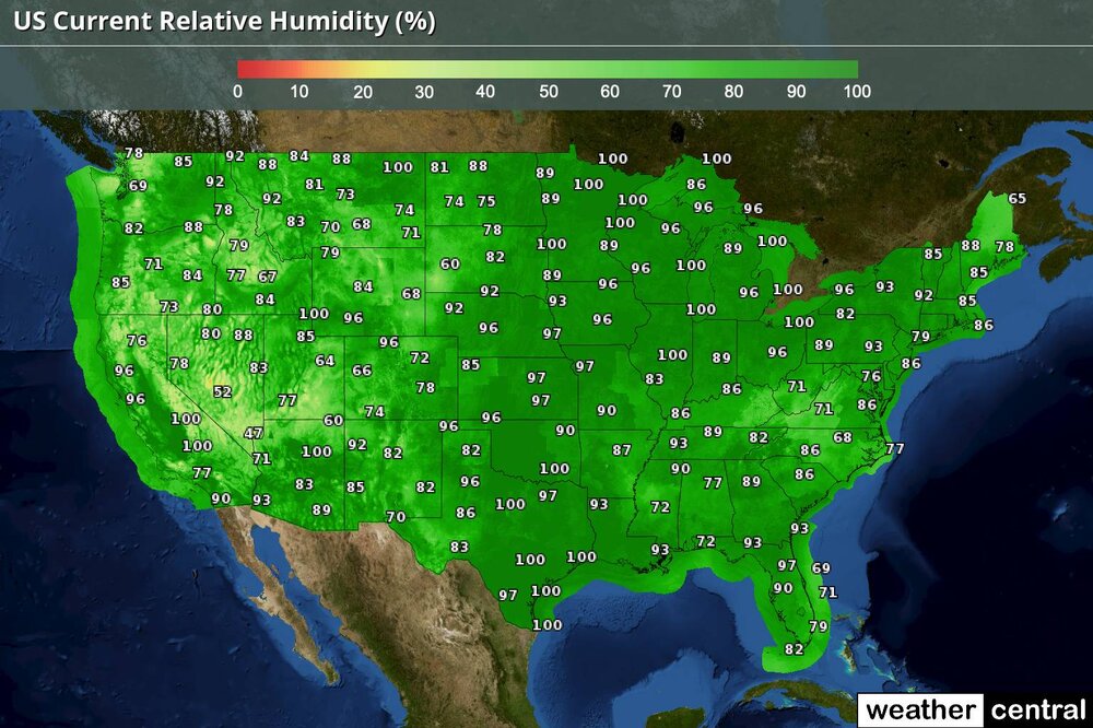
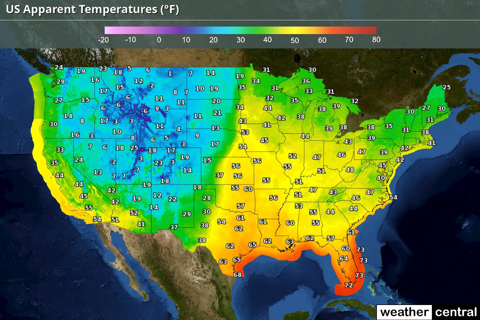
If you ask me these two maps scream a few things:
1. We are in the warm phase of El Nino. It's December 24th and those humidity charts are off the charts where is the cold dry air????
2. It's going to be very difficult to move this moisture laden atmosphere out to establish cold air that is sustained.
3. The warming is well undeniable. I could see if it were July or August and we were looking at this humidity map, but even where it is cold it is humid??
4. With that said warmer air holds more water and if it were to snow, I am sure it would be a 1-2 foot plus snowstorm.
5. These are our new normal I am afraid.
6. Any flow whatsoever off of a body of water Pacific, Gulf of Mexico, Atlantic, and now even the Great Lakes warms various levels of the atmosphere especially lower and mid-levels, and this is another obstacle of snow in this new era.
We definitely would need a pattern progression eastward to even sniff a chance.

-
5 minutes ago, Ralph Wiggum said:
Epic -nao.
- Yea we have been lacking this block the storms from coming straight at us please and more importantly slow the dam pattern down to phase a few storms to our east and southeast, but not too far.
-
1 hour ago, ChescoWx said:
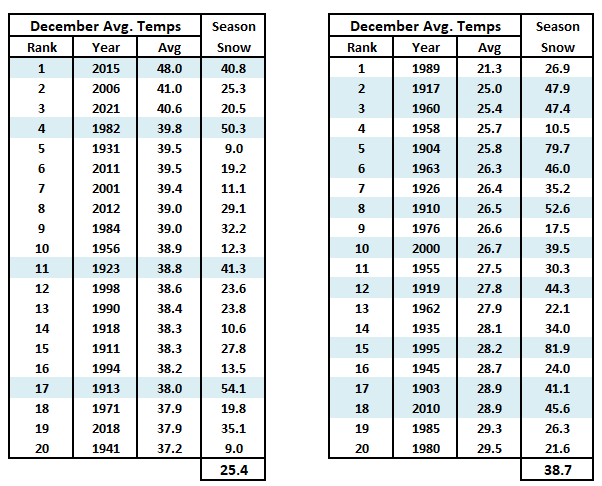
Looking ahead it appears likely that this December will finish as the 4th warmest final month of the year since records began in 1894. See the Top 20 warmest and coldest Decembers below. Of note, in our current warm cycle the top 3 warm December's have all occurred just since 2006!! So does a warm December correlate to a less snowy upcoming winter season? The answer is overall yes. Only 4 of the top 20 warmest December's featured above normal snow seasons (avg. snow 36"). While 10 of the top 20 coldest Decembers featured above normal snow for the upcoming season.
The record books are about to be rewritten so hang on tight!
-
1
-
-
3 hours ago, stormy said:
Guess what? The 18z GFS now transfers energy south at the last minute, and dumps snow on Jan. 6.
8 inches for me and 11 inches for D.C. by Sunday morning. My wish with psu nearly came true!!!!!
Hooray!!!!
Like December 5ths in the past in southern PA... It loves to snow January 6th and 7th around here just ask 1996!
-
2
-
-
4 hours ago, WxUSAF said:
Possibly. There’s a constant stream of gulf moisture into our area starting on the 4th.
Screams overrunning snows with weak areas of low pressure and the caboose of the lows is the storm that develops off the coast those are the classic 1–2-foot snowstorms around here.
-
53 minutes ago, stormy said:
The 12z ECM and EPS say no significant winter weather through Saturday, Jan. 6. Everything is too progressively zonal.
You cannot ignore this because the models over the past three seasons show you what should be happening in a normal winter pattern then flip out and say but this is what you get; just like in Willy Wonka: "You Get Nothing"!!! "Good Day Sir"!!!
-
47 minutes ago, psuhoffman said:
Gfs has a perfect upper and surface low pass on the 29th it’s just about 5 degrees too warm in the boundary layer.
I think we watch this because that storm was once one consolidated storm now we are beginning to see redevelopment off the coast and the cold air is at least trying to catch up so I am still interested a bit in the 29th.
-
26 minutes ago, Kmlwx said:
I usually lurk in the long range threads - and what I am about to say is purely "gut feeling-esque" but this upcoming period while it may not be the "peak climo" or "best odds" - has the feeling of a period of time that might define the remainder of winter. In other words, if we can find a way to make snow work with a less than perfect pattern a time or two in the next 2+ weeks, it feels like something bigger might come "easier" (term used loosely). Similar to how Bob and others say some winter it just "wants to snow"
If we get skunked through like January 10th, it may still be game on for later in the month and into Feb, but it'll have a whole different feel if we can back into or have a few events sneak in before primetime.
Well said my feelings exactly too!
-
1
-
-
1 hour ago, mattie g said:
What a surprise. The typical folks have shown up after this GFS run.
The only thing that matters to me on that GFS Run was that there is a large storm. The storm is in two pieces but its a typical GFS thing to misunderstand the split of energy in a split flow. I am sure that the idea is one consolidated low east of the Delmarva instead which would net you a 1-2 foot snowstorm possibly more if there is decent blocking.
-
1
-
1
-
 2
2
-
-
4 hours ago, stormy said:
As progged by the GEFS, the 28 - 30 system is still too warm. But, it may be setting the stage for the next system by pulling colder air down from the Lakes.
Yes, this is fantasy-land beyond 300 hrs. but we could have a winner in the first 5 days of Jan.
Source of origination, northwest Gulf is prime all the way back to the 60's. Usually a general track to Alabama/ southeast North Carolina and up the east coast has produced. Recently, eastward across the Gulf intensifying up the east coast as the GFS paints is good. Upper air temps. look good to support snow.
The GEFS contradicts itself at 360 by showing rain with a minus 4 850 and the 540 in N.C...... The Op may be onto something.

Warm tongue of air off the Atlantic Ocean way too much fetch it happens often lately going back over the past 15 years especially due to our torched Atlantic Ocean!
-
3.86 here in Media Delaware County generally 3-6" of rain in Southeastern PA lots of streams out of their banks winds basically 25-40 mph at times.
-
Media, Delaware County 3.86" ... on the way in Darby Creek over its banks in Darby.
-
1 minute ago, ChescoWx said:
Latest NAM just a wee bit breezy toward Monday morning...
Now is that at the surface or 2,000 to 5,000 feet up off the surface.


Dec/Jan Medium/Long Range Disco
in Mid Atlantic
Posted
This has been the case for the past few years no cold high up north, warm air trapped at the surface, more and more cloudy nights holding temperatures higher, ocean air entrenched, high humidity levels you can make the inferences.