

Kevin Reilly
-
Posts
2,950 -
Joined
-
Last visited
Content Type
Profiles
Blogs
Forums
American Weather
Media Demo
Store
Gallery
Posts posted by Kevin Reilly
-
-
4 hours ago, RedSky said:
GFS and ECM have 4-5" rain in the extended
Guess drought is done or been done.
-
On 7/3/2025 at 6:55 AM, Mikeymac5306 said:
Not looking like an ideal week in the Outer Banks next week for my vacation

Hopefully things will move progressively which could become the case. I will be in Kitty Hawk first week of August good times in the Banks, but yea better weather is preferred.
-
 1
1
-
-
On 7/1/2025 at 5:35 PM, KamuSnow said:
Surprised you haven't received more, unless you're talking about the last couple of hours. Have 1.05" here in the last 24 hours, including about a half an inch around 2 to 3 am last night.
Total rainfall from everything yesterday and this morning was 0.63" so we were stuck between bandings subsidence.
-
79f humidity 92% Cloudy a few drops some thunder far distance. Had a rogue lightning strike that temporarily knocked out the tv. So far trace of rain kind of meh so far.
-
1
-
-
Light Rain 77f humidity 96% dew point 76f
Total Rainfall today so far 0.02"
-
No power still 35 hours and counting no restoration time estimated.
-
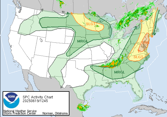 Enhanced risk of severe thunderstorms today I guess it’s possible for a tornado watch today starting around 1-2 pm. Looks like we have a difluent split in the flow which also probably means isolated to scattered strong activity rather than a squall line.
-
2
-
-
Over here just lifted north Low right on top of Media heading NNE winds clouds switched around to the NW a few minutes ago. Ended with exactly 1.00” since 8:30 pm.
witnessed a tree on fire and telephone pole on fire from tree falling Barren Road and Painter Road Middletown Twp Delaware County. I called 911 fire police on scene in minutes. Great job!!!
-
24 minutes ago, RedSky said:
Looks like trouble this is the time for flood guy
Oh, it is coming a wall of rain, wind, and embedded thunderstorms with isolated tornadoes marching NNE.
My under over is 2.27"
-
64f got nailed pretty good at peak SW winds gusted to 40-45 mph picked up 1.07” in 30 minutes long duration lightning and thunder all elevated no strikes.
-
2
-
-
Mostly Cloudy breezy SSW wind 15-25 Pressure 29.76 steady 79f heat index 80 humidity 58% dew point 63 high so far 82f
-
37 minutes ago, RedSky said:
GFS/NAM around .25" through mid afternoon Sunday then the bulk falls late day into Monday 1.25" additional
RGEM .75" total southeast PA through Monday ouch
So…. Euro had 10” a few days ago and what I’m seeing the percent starts at 90% then drops to 80% the drops to 60% then drops to 40% then drops to 30% then zippo. This has become tracking a winter storm like looking for a needle in a haystack.
NWS last night had heavy rain here for 3 days see about that!
Guess it depends where the front and storm get stuck.
Think someone said a few pages back hope the rain stops by next Saturday! Can’t stop if it doesn’t start.
also nice to see the Southeast Ridge Bermuda high in place like it’s mid summer damm lightning bugs brought it I’m sure.
-
 1
1
-
-
71 f humidity 86% dew point 67f Cloudy, breezy West-southwest winds gusting to 27 mph.
Total rainfall so far: 0.02"
-
1
-
-
56f humidity 28% dewpoint 26f
NE wind 7 mph
The La Niña dry has returned
-
14 minutes ago, RedSky said:
Alburtis is a stones throw away from you they got 2.3" what the hell happened lol
Local elevation anomaly.
-
1 hour ago, ChescoWx said:Some area snowfall reports around the area from the NWS this morning....Berks County...Huffs Church 2.5 in 0726 AM 04/12 Trained SpotterAlburtis 4.7 SW 2.3 in 0700 AM 04/12 COCORAHSLyons 2.6 SE 2.0 in 0700 AM 04/12 COCORAHSFleetwood 2 ESE 1.3 in 0700 AM 04/12 COCORAHSMohnton 2.8 SSW 0.7 in 0800 AM 04/12 COCORAHSFleetwood 4.8 ESE 0.5 in 0700 AM 04/12 COCORAHSMorgantown 0.5 in 0730 AM 04/12 Public...Bucks County...1.2 NE Springtown 0.3 in 0710 AM 04/12 COOP...Carbon County...Lake Harmony 2.4 WNW 3.2 in 0700 AM 04/12 COCORAHS...Chester County...East Nantmeal 1.0 SSW 0.3 in 0930 AM 04/12 COCORAHS...Lehigh County...Salisbury Twp 1.4 in 0830 AM 04/12 Trained SpotterWashington Twp 0.5 in 0848 AM 04/12 Trained Spotter
Any reports for up towards like Mount Pocono / Hawley Pa Bushkills Fall
-
1
-
-
18 minutes ago, 21chuck said:
Some radarscope user is reporting falling snow in Springfield! I assumed it was a joke.
Here in Media sleet with darting snow flakes we are west southwest of Philly so yes no joke 35f sleet and snow some sleet accumulation on the cars. It probably won’t last long once the sun works that 1-2 degrees of radiation will quickly put an end to any sleet and snow warm the surface just enough to change everything back to rain most areas except very highest elevations up north. In addition the intensity of the precipitation is lightening up now so cold air transport to the surface is starting to break down now here.
Currently light rain and sleet mixed now lost the darting snow flakes.
Total Rain: 1.80”
-
3
-
-
Sleet and snow accumulation on the cars 36f
-
1
-
 1
1
-
-
Moderate to Heavy Rain 43f dewpoint 42f humidity 99% wind NNE 14 gusts to 26
Total Rain thus far: 0.88"
I am guessing we would be snow now if this were January, February, or early March and we would have
about 3-5" of snow on the ground and coming down an inch or two an hour.
-
2
-
-
Cloudy 41f light drizzle rain awful out there!
If only it was January or February.
I have my new rain gauge out and ready to go let’s do this!!
Snow north and west I’ll have my snow board ready just in case lol who am I kidding.
I will just enjoy the rain.
-
1
-
-
Media Low clouds fog drizzle 48f ENE wind at 8 mph
Overnight low clouds / fog / drizzle
Rainfall amounts: trace to 0.02
I did drive by Springton Reservoir yesterday it is up about 10% since early March when I last saw it.
-
1
-
-
On 4/3/2025 at 4:06 PM, Birds~69 said:
76F/DP 64F
Somewhat muggy. Hopefully something develops and takes the roof off the house or blows the trash cans into another state...
Funny you said this because that’s exactly what happened here in Media at 4:45 am this morning.
-
7 hours ago, RedSky said:
Oh dang we lost both snow events. Back in your pod Ralph.
Patience is needed.
-
Not one drop of rain here today to this point here windy cloudy and temps 63f to 70f
High today here 70f
Currently 63f winds South 26 mph gusting to 37 mph.
Rain today: 0.00
Tropical Depression Three
in Tropical Headquarters
Posted
Good outflow aloft. Looks like depression to me or even a 40-45 mph Tropical Storm Chantal.
Small Upper level low just southeast of Atlanta Georgia and dry air punching in from the northwest should limit development but also should tug what could become Chantal towards the southeast South and North Carolina coastline before gradually moving back off to the northeast.
Another interesting area well to the east of the Bahamas. Things waking up a bit out there.