

Kevin Reilly
-
Posts
2,154 -
Joined
-
Last visited
Content Type
Profiles
Blogs
Forums
American Weather
Media Demo
Store
Gallery
Posts posted by Kevin Reilly
-
-
1 hour ago, LVblizzard said:
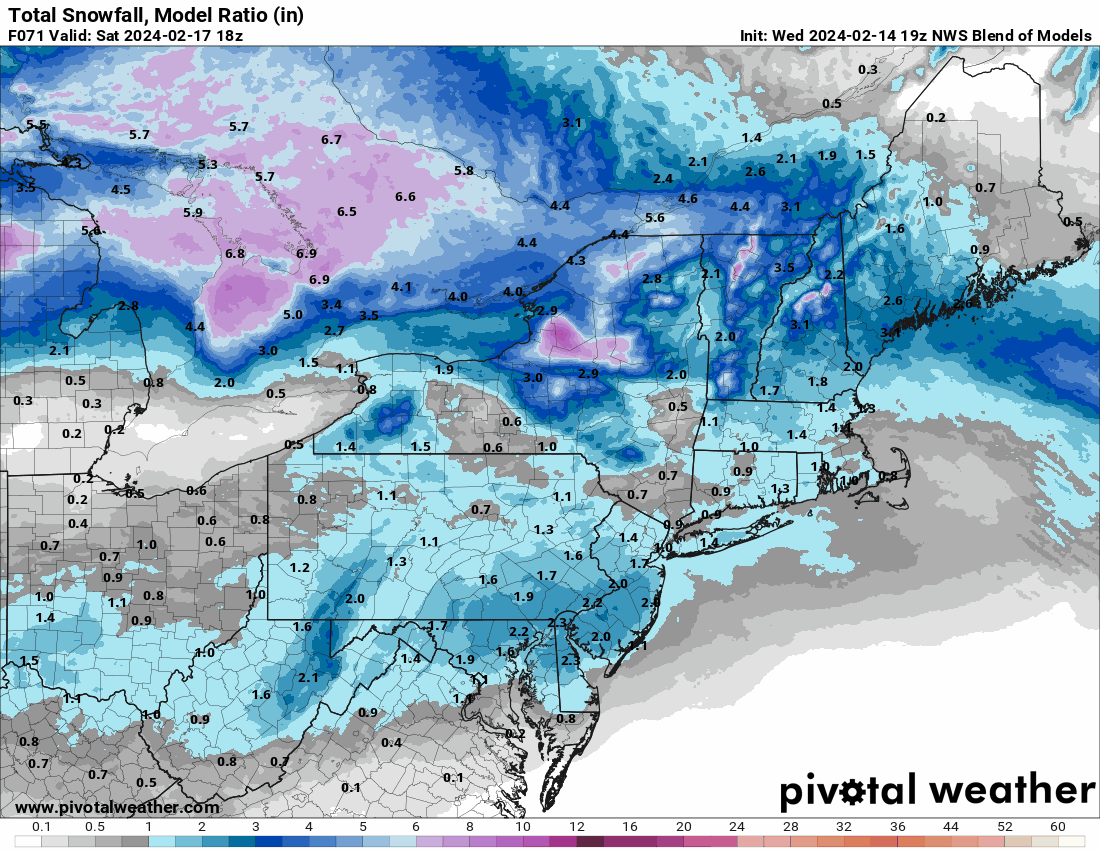
Some of the GEFS members say Friday night-Saturday could be significant. Ceiling is high-ish with this one but we need a lot to go right. Most likely scenario still seems to be a widespread 1-3”/2-4” event.
Now these types of systems can be very sneaky in February. We have the southern zones heating up more rapidly and then we have our cold grounds now with snowpack just to our north with us being colder relative to what's going on to our south. This could set up quite a temperature gradient for snowfall to band and set up an overrunning event with decent accent / lift. Don't sleep on the possibility of the system midnight Saturday to 12 pm Saturday to be an overperformer!
-
2 hours ago, Hurricane Agnes said:
Throwing the 19z NBM in for Friday night/Saturday morning.
As an obs - I actually managed to stay above freezing all night and then finally dropped to 31 for a "low" at 9 am this morning. Was actually surprised at the temps as I expected to get higher today but nope. High ended up at 36 with a chilly breeze to boot. Lots of snow melt on roofs and streets/walks but parking lot mounds that were still around from the last storm, got a complete refresh.
When I was out today I noticed there was a "haze" of very high clouds that the sun was blazing through.
In any case, am currently 35 with an arctic-like dp of 13.
My low for today just happened right now I am at 28.7f the lowest temperature from this morning between midnight and 6 am was 32.4f thanks to the clouds off of the Great Lakes higher humidity and dewpoints capping temperatures.
-
3 hours ago, Albedoman said:
If this scenario holds at the 00z and or 06z runs ,WWA should be issued for the LV and for Montgomery /Bucks County by Friday morning. The real take on this run of the NAM is that the ground will still be snow covered from Tuesday's snow which will aid tremendously in the accumulation of the snow on grassy surfaces. In other words the typical white rain scenario is thrown out the door as even the roads will cave immediately if not brine or salted. I expect a shit load of brine to be used on the roads around here on Friday afternoon. Furthermore at five inches, coming closer for a Winter storm watch to be issued for Montgomery and Bucks too. Elevation again is a factor as the South Mountain range appears to be in the bullseye on this NAM run. Definitely be a plowable event too if this comes to fruition.
I like what you are saying about snow on snow. That is NOT the case down here anyone east of the Blue Route 476 in Delaware County now have zero snowpack.
It was an amazing ride this morning from Media driving ESE 7.4 miles to zero snow and also a temp in Media at 31f to a temp with no snow on the ground at 38f. The differences from Central, Western, and Northwestern Delaware County to the River were in one word DRAMATIC when it came to snowfall accumulations from yesterday.
-
 1
1
-
-
21 minutes ago, ChescoWx said:
Nice relative agreement on all models....unusual! I'm running a 5k that day....so it will happen!


Kamu and I will take the 3-5" sweet spot for $1,000 sold!
-
 2
2
-
-
23 minutes ago, RedSky said:
Come on come on..... Double or nothing baby come on!! Hmm with all this talk of water vapor on the other forum maybe we can go 3-6" here.
-
1
-
-
4 minutes ago, GramaxRefugee said:
Largest ever recorded by modern scientific instruments. Largest of satellite era. 1000 times the Hiroshima bomb. You are on to something young man.
It's yet another variable into our "unknown". I am sure (the main term here that you used water vapor) being launched high up into the atmosphere MUST have an effect on our climate for sure.
-
27 minutes ago, Ralph Wiggum said:
Before I went on my rant in early Feb then subsequently took some time away, I noted in the Philly forum to tread lightly with the weeklies and the epic looks. Of course I got booed off the forum even suggesting that. But in all seriousness I will reiterate what I did at that time. Many of these extended products are heavily weighted on past analogs when there are rolled out. So if a group of indices like the QBO, PDO, enso etc match a particular year (let's use 2010 as an example because this year had many similar key features), then the weeklies would tend to spit out something similar that transpired during those analog years. Not saying this is sole reason we got the head fake, but partly is due to this, of that I have no doubt. Many of us actually discussed this in the past and there is truth to the algorithms involved in creating an extended product. Now could I tell you which specific products use more of the analog data? No, I dont have that I fo, but maybe a red tagger would?
I look at this differently welcome to the new normal?
-
1 hour ago, RU848789 said:
It's all about intensity in marginal setups (and getting snow instead of rain, lol - the changeover was delayed from about 276/195 southward where people really got a lot less than modeled and forecast by some) - see my latest post on that. We got 6" in Metuchen with an 8.3:1 ratio and temps generally 33F for the storm. Anyway, here's a good map on snowfall amounts. Also, Bordentown is barely CNJ and much of CNJ got 5-8".

You certainly missed one besides intensity elevation played a huge role. Look at the Fall line! The heavy snow matched perfectly to the fall line snow 6"+ was north and west of the fall line.
-
2 hours ago, Birds~69 said:
Philly received 0.6"...
And there it is elevation and warmer air trapped along the Delaware River. Think my totals for Delaware County last night were spot on from what I saw.
-
1
-
-
39 partly sunny here rapid melt off on-going. Total snowfall here in Media 3.3" before the compaction took place. I drove 2 miles south to lower elevated side of Media clearly less.
-
24 minutes ago, Hurricane Agnes said:
Yeti has awoken!


I still think you are in the pivot area.
clearing pressing down from the NW now pretty interesting signatures on the radar on the back end looks like little bursts of snow.
-
snow picking back up here in Media power just went off for a few minutes 32.9f
Total snowfall 2.6"
-
Light to moderate snow here 32.7f dewpoint 32f pressure 29.44 wind NE 15-22.
measured 2.4" I think my 2-4" for Media will work out.
I am very curious to see how the southeastern zones of Delaware County are doing I bet they are like 1-2" down along the River say Folsom, Ridley, Glenolden, Sharon Hill, Colwyn I am sure elevation is doing its thing the way the changeover moved through.
Anyone in the Newtown Square area to Radnor and Wayne would love to know your snow totals too gives a flavor of elevation.
Kamu snow Garnet Valley probably same as Media 2.4" or so?
Checked out Ocean City Maryland last hour 29.29 981.8 mb so that's your storm and energy over DCA transferring to the Coast has been in progress.
Back edge moving on down from the NNW and NW. They probably did not get much out in State College.
-
Snow in past few minutes has really lighted up here clearly see the banding setting up along the Route 202 corridor moving NE.
Call it light to moderate snow here now 32.7f about 2"
-
1
-
-
Heavy Snow past hour and still coming down clearly 1-2" an hour rates eyeballing it we are likely around 2" or so here in Media Delaware County 32.7f.
4 am a bit of sleet mixed with rain
5 am more sleet mixed with rain
6 am 100% sleet
6:15 am 100% snow has been snowing since.
-
1
-
-
1 minute ago, Scraff said:
Oh sweet! I had Baroclinic Leaf on my Bingo card.

That's classic take a look at the radar down there in NE Kentucky Wow! A clear center and another racing up from the south almost looks like they want to co locate.
-
42.1f humidity 95% dewpoint now up to 41f but wind has now shifted to the NNE light.
-
1
-
-
-
1
-
-
I bet Delaware County is split in half Northern and Western Parts of Delaware County go under a Winter Storm Warning 3-5" and the east side goes Winter Weather Advisory 1-3" that would actually be a good call for around down here and let the chips fall where they may. In the mean time we have light drizzle 42.3f dewpoint up to 39f now.
-
5 minutes ago, anthonyweather said:
RGEM


.This is exactly my thinking from earlier. This climo and temp wise makes total sense really. I mean I am a snow weenie but I would say yes to this.
-
1 minute ago, RedSky said:
This just in Uncle Ukie will be sitting next to Andy in the KC victory parade holding the coveted golden snowflake trophy high for all to see.
Now to be fair the Ukie did have a foot of snow clear into South Jersey I do not think that will verify, but who knows we are in "new times".
-
5 minutes ago, Ralph Wiggum said:
Tuckerton, NJ / Little Egg Harbor jackpot 2 straight runs

It's sleet warm tonuge of air coming off the ocean.
-
1 minute ago, Ralph Wiggum said:
Looking more and more like a general widespread 4-8". I consider that damn good. And we have wsw's.
Down here in Media Delaware County I am going to take these factors into mind here in Central Delaware County:
1. Temps above freezing overnight.
2. Warm ground temps.
3. elevation
4. rate dependent snows
My snowfall totals in Delaware County:
Media 2-4"
Ridley 1-3"
Newtown Square 3-6"
All broughs along the Delaware River 1-2"
Garnet Valley 3-5"
Radnor 3-6"
Havertown 2-4"
Springfield 2-4"
Broomall / Marple 2-4"
Chester 1-2"
Swarthmore 1-3"
Clifton Heights 1-3"
Upper Darby 1-3"
Drexel Hill 1-3"
Eastern Delaware County 1-2"
Think I covered it.
-
1
-
-
1 hour ago, Ralph Wiggum said:
Just like claiming victory prematurely I probably shouldnt accept failure yet, but my thinking that this was too early in the pattern change and SE PA would be close but no cigar looks like an epic fail. But those are the fails I like...so yeah.
Relax Ralph it has not happened yet. I too STILL have my doubts. We shall see currently 42.3f dewpoint 37f so we aren't close to changeover yet, but I know not to look for this prior to 5 am here.


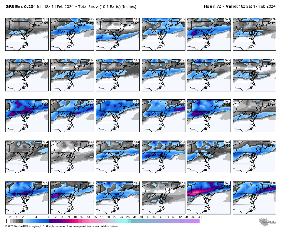
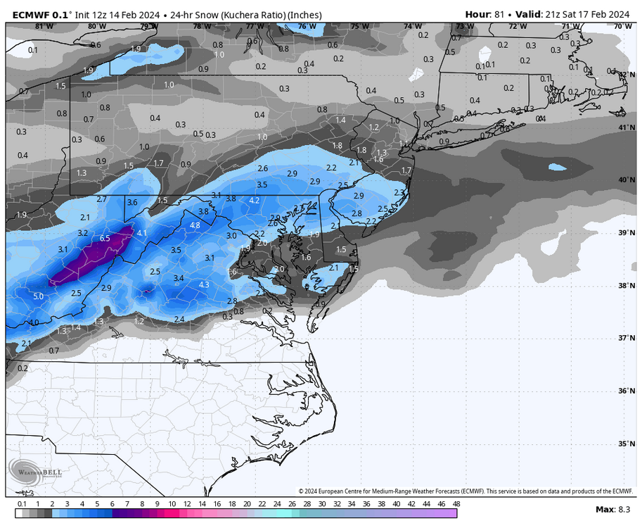
The Weekend Rule? Saturday 2/17 - The Icon Storm
in Mid Atlantic
Posted
Yea let's see if we can play the February temperature gradient and make this a 4-8" overrunning event hmm???