

Kevin Reilly
-
Posts
2,950 -
Joined
-
Last visited
Content Type
Profiles
Blogs
Forums
American Weather
Media Demo
Store
Gallery
Posts posted by Kevin Reilly
-
-
3 hours ago, RedSky said:
Clear as a bell
Completely socked in here with ocean clouds. A wall of clouds rolled in from the sky east at 7 pm.
you can see it on the visible satellite right into SE Pa over this guy!
-
1 hour ago, Albedoman said:
the levels in the Little Lehigh are the lowest I have everseen in the last 40+ years for the spring. Its rough as the base flows of the stream are srt to dry up quickly as the vegetation and trees come out of dormancy. Its only going to get worse. The dense morning fog by the end of the week will help some with the extremely dry humidity but we really need a stationary front over us for two weeks at this rate. The recent dry winds of 35 + are killing us. . I see nothing significant until April. An onion snow will do nothing for the drought too. we need a 16 inch wet snow to at least get the grass green. I have never seen this yellow in march ever.
Any idea how Bushkill Falls are fairing up north may take a look and do some hiking up there in April.
-
1 hour ago, NorthArlington101 said:
Fringed
That matches the winter of 2024-2025 perfectly it's on!!
-
On 3/6/2025 at 1:24 PM, paulythegun said:
BOOM!
65 and sunny next run or maybe it shows this for three more runs then has the storm down in Jacksonville heading due east.
-
2 hours ago, RedSky said:
Finally getting a clipper approaching and it's weak sauce city
Yea I am watching the clouds ripping east southeast by the moon and temps rising from 40 to 45 in the last hour. Humidity 35-40% right.
-
On 3/6/2025 at 2:44 PM, MGorse said:
Yea but it hit the ground and ran right off streams rose a bit then fell right back down again. Now the next chance of real rain is a ways away. Next week will probably be 60's and 70's with 25-30% humidity wind and fires again. At least down here we are going to need multiple days possibly weeks of steady rain.
I mean the event was something most we have seen around here in weeks. Gotta start somewhere.
-
Way home was quite wet 1-2 feet of water running through the streets along Darby Creek around McDade Blvd Darby Delaware County winds gusting to 40 mph 3:30 to 4:00
-
1 hour ago, BBasile said:
I want this. Could do without all the damage, though.
No wind here
heavy rain for about 5 minutes from the area you highlighted.
that’s the report with that it’s all aloft makes sense too with 981 mb racing NE over Chicago but new low pressure is probably developing near by.
-
52 minutes ago, Birds~69 said:
Yeah, warnings galore down that way. (sister lives there)...sun poking out here.

Hmmm sun instability but not here
-
 1
1
-
-
1 hour ago, RedSky said:
Radar history is on average .25 to .50" in the state
Hmmm my under over is 0.40” and 44 mph
-
4 hours ago, JTA66 said:
Tomorrow is trash night, wouldn’t expect anything else from the weather.
Here too trash night the models have nailed this many times this year!
-
 1
1
-
-
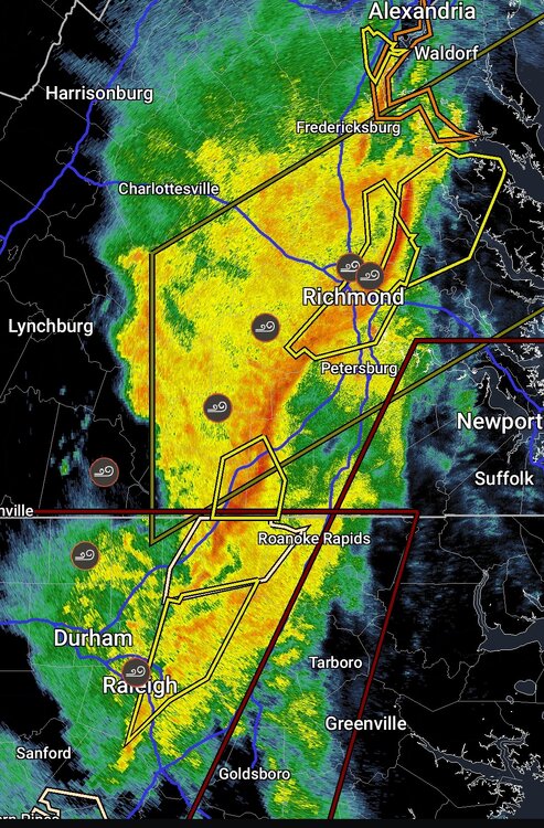
4 hours ago, Birds~69 said:
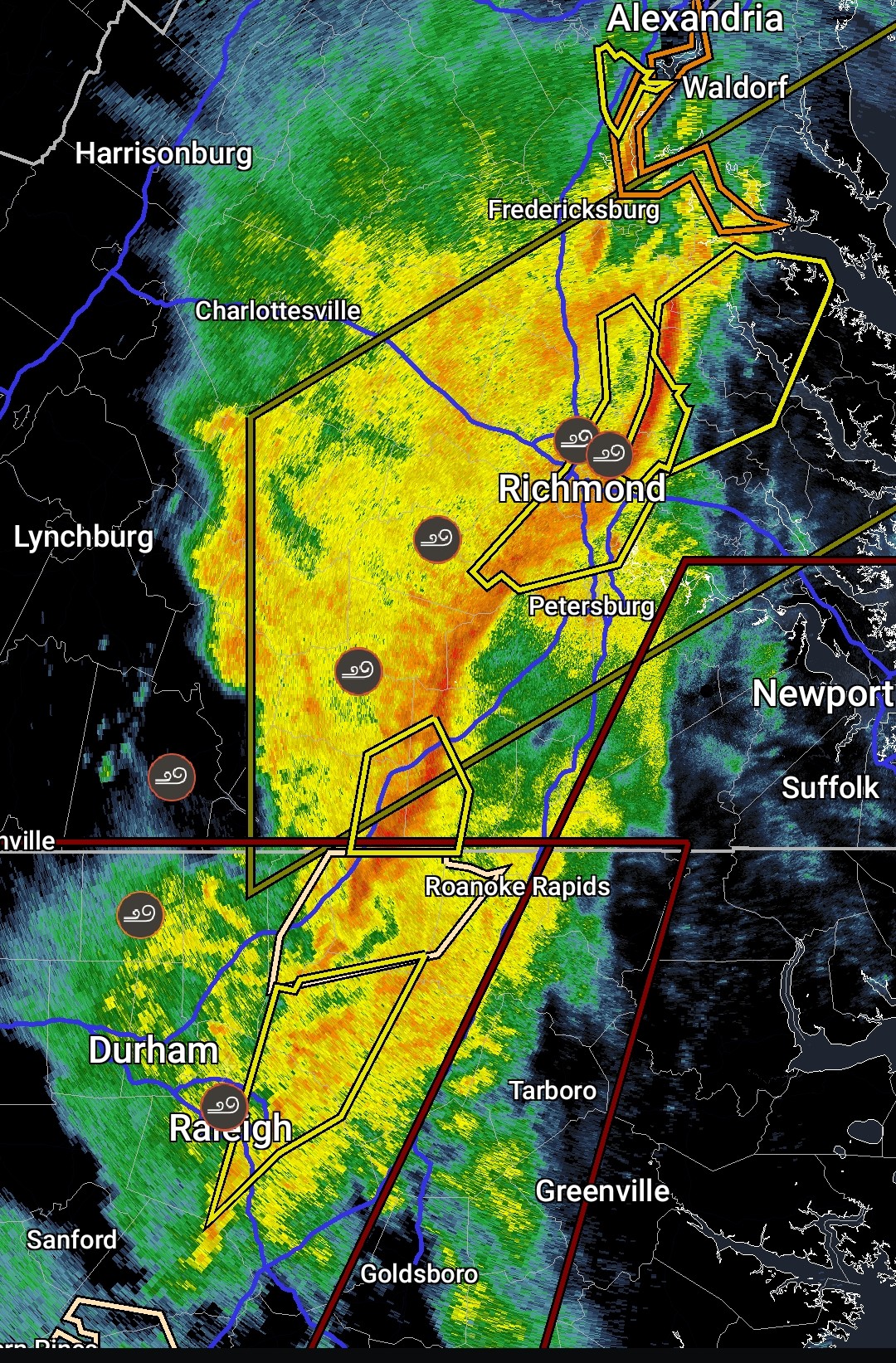
6abc 6pm going with start time 2:00 p.m. lasting to 8:00 (W to E) storms, 45 to 50 mph gust with one half to one inch of rain. To drought guys dismay, certainly doesn't look like a drought buster...
56F
Umm this is basically one squall line a few showers in front and back then outta here.
My under over tomorrow down here is 0.40"
My under over wind tomorrow is 44 mph.
-
GEFS actually in a better spot for SE PA but we’ve seen this song and dance this is where everything gets shoved further south.
-
 1
1
-
-
Oh wait it’s the American model didn’t they cut that model to save money.
-
1 hour ago, Ralph Wiggum said:
Wasnt the gfs the model that led the way with the feb 20 'event' where all models had us getting crushed but the gfs was by itself and well south?
15 runs and I’m interested lol
-
41 minutes ago, Ralph Wiggum said:
We got this one
Yea right lol…. That set up is so flawed for snow.
1. No cold high up north
2. primary almost to western PA
3. 981 cruising near DCA ene way too close as warmer air floods off the Atlantic.
4. Oh look a Great Lakes low.
5. sun angle etc relative surface warmth.
6. 18z will be 66 and sunny with 25% humidity and west southwest winds gusting 30-35 with scattered fires.
-
1
-
-
8 minutes ago, Albedoman said:
Next wednesday rains/t storms could place a significant dent into the drought conditions. Highs near 60+ with moderate to heavy rains will help melt the soil horizons frozen conditions quickly and get some much needed water through to the root structures of the trees and plants for budding and leafing out in mid April. Believe me, this is a multi billion dollar rain event for farmers and landscapers. Lets hope it comes to fruition and we just don't get burned with another .25 in light rain/drizzle event
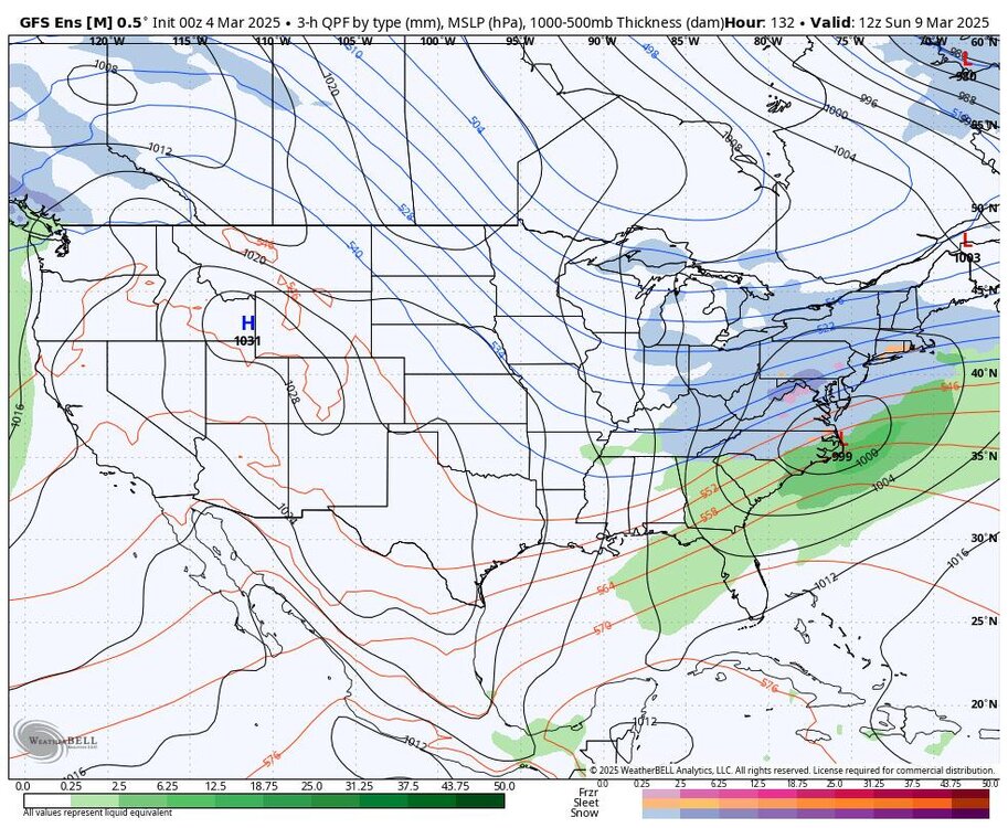
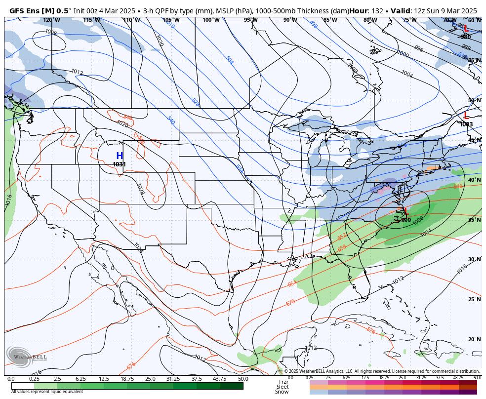
We should start a thread looks like a 984 mb low in the Ohio Valley wind rain severe thunderstorms 2-3” of rain and 1-2’ of snow in northwest flank.
-
Are we still tracking the Joe Bastardi March 1993 type storm he said is possible or is that a no go?
-
 1
1
-
-
6 hours ago, Birds~69 said:
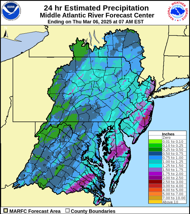
With today's rainfall, the drought should be over.
Still some mounds in parking lots and may make it through the weekend w/highs in the 30s. After that, probably on life support/hospice...
54F/Cloudy
Yea big dent in the drought here today 0.02”
-
1
-
-
10 minutes ago, winter_warlock said:
180 hours away. Time for a Southeast shift
100% it is rain and it will verify.
-
 1
1
-
-

#12 is happening book it for this area lol
-
1
-
-
1 hour ago, LVblizzard said:
Super boring pattern setting up for the next 1-2 weeks. I'm not ready to write this winter off just yet though. I think we get a storm or two to track in March.
Good luck!
Storm track way north and another storm track way south the only thing we see is wind and rain later.
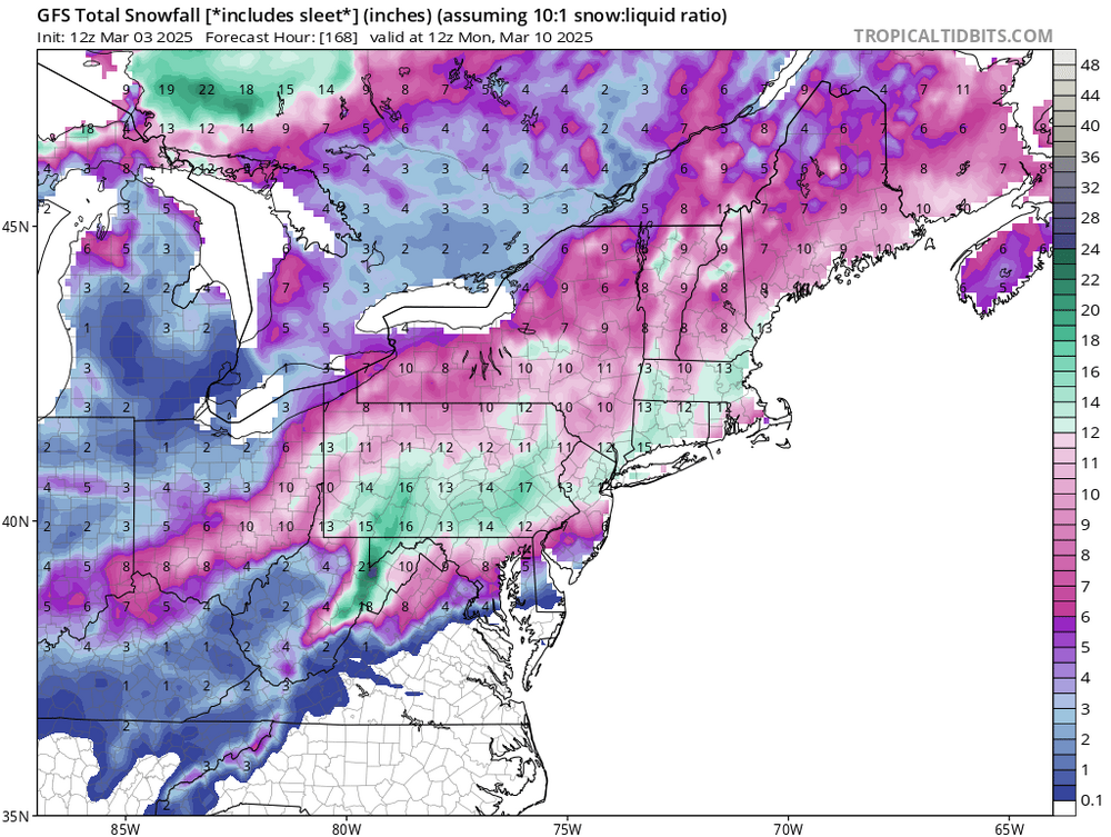
I cannot rule out a light 1” event on the grass down this way and 2-4” up your way.
ways I see it were are done!
-
8 hours ago, The Iceman said:
“Here's my winter forecast:
Temps:
Dec +1 - +3
Jan +2 - +4
Feb +4 - +6
Mar +1 - +3
Overall +2 - +4
Snowfall at select locations
PHL 5-10"
TTN 8-14"
ABE 15-20"
ACY 4-8"
With how northern stream dominant the pattern has been this fall, I do think we see a return of the clipper this winter. Think this is how we receive most of our snow with several 1-3"/2-4" storms. I think this will also be a winter of big swings. Some pretty good cold shots followed by temps in the 70's a few days later. I don't see weeks on end of it being cold or warm. Precip overall below normal with a lack of southern stream interaction. We may sneak in a miller B that provides the area with it's biggest snowfall of the year(4-8" type deal) but not seeing a blockbuster as I expect the NAO to remain”
I can’t figure out how to cross quote on mobile but this was my winter forecast from November 1st. Overall not bad snow wise and pattern wise, but definitely too warm temp wise. We never really saw huge positive departures this winter. Snowfall wise pretty on point for most areas probably too low in acy and Philly.
overall I give winter a B-. We are going to finish slightly below average snow wise but it was mostly cold and we had a lot of snow events even if they were all small advisory events. Some slightly better luck and this would have been a memorable winter. But compared to the last few, it actually felt like winter this year for a full season not just for a few days or weeks so that’s a win in my book.
12.83” total here that’s all with 2 freezing rain events we sleet and severe thunderstorms 3 times with hail along with damaging winds up to 65-70 mph Presidents Day Weekend pretty active but precip meh.
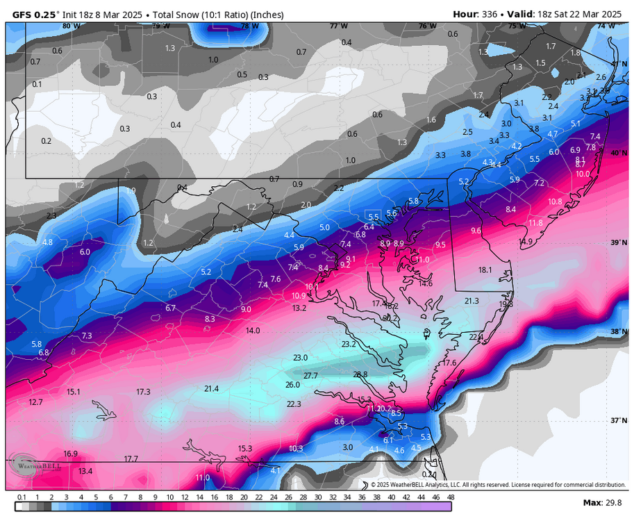
ACY got way more than 4-8” thru got more than that in one storm.
it was like a split more north more south with little in the middle difluence the entire winter here bad kind of blocking lol.
-
11 hours ago, JTA66 said:
One memory...the Eagles/Rams playoff game. Probably our biggest event of the season, but an underperformer.
Not here we barely cleared 2”


E PA/NJ/DE Spring 2025 Obs/Discussion
in Philadelphia Region
Posted
Oh it's trash night here so wind on!!