

Kevin Reilly
-
Posts
2,154 -
Joined
-
Last visited
Content Type
Profiles
Blogs
Forums
American Weather
Media Demo
Store
Gallery
Posts posted by Kevin Reilly
-
-
1 hour ago, T. August said:
Wow ukmet way south. It’s a shame it’s beyond dry lol. It’s weird how as the op GFS keeps going north, its ens is shifting south. What is the reason for that?
probably means GFS is going to come back south again tonight watch.
-
3 minutes ago, RedSky said:
GFS and euro have merged ideas and the results are mediocre we need a south trend
30 miles or so?
Definitely seeing a model consensus coming together kind of classic really. However I would suspect some ticks and changes about 84-96 hours out one way or the other I bet.
-
2 minutes ago, RedSky said:
GFS and euro have merged ideas and the results are mediocre we need a south trend
30 miles or so?
LOL try 55-70 miles or so for most of us south the turnpike.
-
48 minutes ago, ChescoWx said:
The NBM with it's nice blend has done IMHO the best job with storms so far this season...If I were in the Lehigh Valley and on northbound from there I would be pretty optimistic about snow. Down in southern climes like where I am....not so much.
A
A lot of this south of the Turnpike is most likely not amounting to much other than the grass etc. due to temps, radiational heating, and ground temps.
-
 1
1
-
-
14 minutes ago, Hurricane Agnes said:
Ukie is like "The GFS NAM'd you, so 'nope'".

I guess this is the weaker wave further south solution lol.
-
3 hours ago, MGorse said:
This storm setup has that look though of an area of heavy banding which would be all snow as the column cools. We shall see. I just want to know, how much snow for Philly?
")
I will take a stab at it looking at 40f when precip begins and temps falling to 32-34 , warm grounds, sun angle, lower elevations coating to 2" mainly on the grass away from the Delaware River places like Media, Delaware County up along the Blue Route to the Turnpike or so. Elevation will play a role for sure and dynamics. I am not sure though if the storm track and trends are done here think we know for sure in 24 hours or so.
-
2
-
-
21 minutes ago, MillvilleWx said:
I really like the period from the last full week of Feb through mid-March. We’ve scored in that time frame before. I think expectations for the lowlands should be tempered (I know you know lol), but the climo favored areas with elevation and/or latitude should be keen on watching what’s coming down the pike.
Yep Lake Tahoe March Winter Incoming!
-
1
-
-
1 hour ago, Ralph Wiggum said:
The problem is the antecedent airmass. Isn't that cold tbh. That's why the later threat(s) after PD hold the best potential still imo. The 13th is going to be a tantalizingly close tease outside of higher elevations imho. I could be wrong, the 0z GFS might be right. 6z barely backed off the threading of the needle for Philly proper.
Yea temps are meh..... the only way we get snow from this in extreme southeast pa is if this storm drops from its 991 mb to 983 mb like it is showing I have my doubts. I mean 7 am in Media rain and 35f then falls to 33f with snow wet snow with warm ground temps between 10 am and 1 pm Tuesday for accumulations just doesn't work. We Track Though! 12z to 0z today will be telling.
After the 15th and beyond is where it always has been at but we will not know about those details until at least Tuesday when this storm gets out of here and the next clipper approaches from the Great Lakes and how the STJ either interacts with the NS or not. It is not out of the question it even gets meh out in time with more of a zonal flatter flow with blocking up top it would be just our luck!
-
6 hours ago, RedSky said:
The snow falls midnight to 8am Valentine's morning, la la lock it up lol
*Right about the timing but off on the day whatever
GFS and Euro timing is off by a lot both are ejecting the energy in the Southwest with different timing. My guestimate say we know later at 12z today and 0z tonight what this will look like in regards to how much of this is rain and how much of this is snow etc.
-
Cmc is way further south compared to its last 2 runs, but it is a much weaker wave with zero dynamics boring rain with temps in the upper 30's to lower 40's
-
2 minutes ago, DarkSharkWX said:
CMC further S too
That's important for tonight, I think.
-
1
-
-
3 minutes ago, stormtracker said:
White rain baby
Subtle changes if the flow goes progressive ever so slightly east, we get hammered like 70 miles further east think we can manage that 115 hours out? Looks like a low rides to WV transfers east we would like the intial low just a bit more souther.
-
7 minutes ago, Birds~69 said:
Would like to see more consistency w/tonight's late night 00z runs. I'll take a 1-3" to 3-6" rain to snow plaster in a heartbeat....then cold.
42F/Cloudy
You will not get it from the ICON Model Lol. However it is consistently bad.
-
41 minutes ago, high risk said:
It always warms my heart to see the snow depth maps posted here, but this is not the type of event for which they do well. They limit accumulation when surface temps and soil are warm, and they'll never capture the ability of heavy rates to overcome marginal thermodynamics. I'd probably either average the 10:1 and snow depth products or mentally adjust the 10:1 maps downward. Kuchera maps might be good too - I hate how generous they are with colder temps, but they seem to properly limit accumulations when the temperature is marginal.
Don't forget the increasing sun angle between 10:30 am and 2:30 pm.
-
19 minutes ago, MGorse said:
Looks like the 12z GFS did not go way north.
It is on an island by itself unfortunately. Ukie, Euro, CMC, ICON vs. GFS and GEFS AT least we can say there is still a chance!
-
1
-
-
2 minutes ago, NorthArlington101 said:
GEFS is looking like it’s going to follow the GFS and improve.
FWIW it looked like the CMC rushes to Syracuse but gets Shunted ESE so maybe it trends tomorrow to GFS and GEFS we shall see. Euro will be telling.
-
1 minute ago, jayyy said:
Do tellTake away storm further south, cold air crashing in, temps falling to 32 in SE PA with 9-11" of snow and falling to 34 with 3-6" in Baltimore not a dumpster fire LOL
-
1
-
-
1 minute ago, RedSky said:
9-11" on the 10:1
okay lock that up and we didn't see the CMC.
-
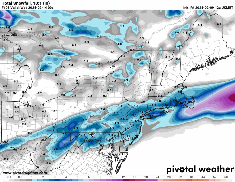
Anyone got a snowfall map for the 0z GFS? CMC? LOL
-
3 minutes ago, RedSky said:
Yes it was south of 18z knew it was coming
CMC to Syracuse to eastern Long Island Love it LOL!
-
UMMM hour 138 GFS anyone umm!! Anyone!
-
2 hours ago, Solution Man said:

Yea I should have been more specific I laughed at the 18z GFS and I don't believe at all what it was selling. I do not take many 18z runs "off runs" very seriously. Looks like it went out to lunch!
-
 1
1
-
-
18z GFS wow! What -NAO LOL... What a dumpster fire!
-
 1
1
-
 3
3
-
-
1 hour ago, Steve25 said:
"It was in the 40's at 1 PM the day before that digital blue! Torch! Horrible setup!"
Umm March 12th 1993 it was 62f before we got whacked! PHL picked up 13" of now and 4" of sleet with a rainbow at the end.
It started snowing at 11 pm at 42f.
What we need is dynamics.
-
2
-

E PA/NJ/DE Winter 2023-2024 OBS/Discussion
in Philadelphia Region
Posted
Yea 310' here in Media just won't cut it lol