

Kevin Reilly
-
Posts
2,154 -
Joined
-
Last visited
Content Type
Profiles
Blogs
Forums
American Weather
Media Demo
Store
Gallery
Posts posted by Kevin Reilly
-
-
Just now, Birds~69 said:
CBS3 gives Philly just about squat...
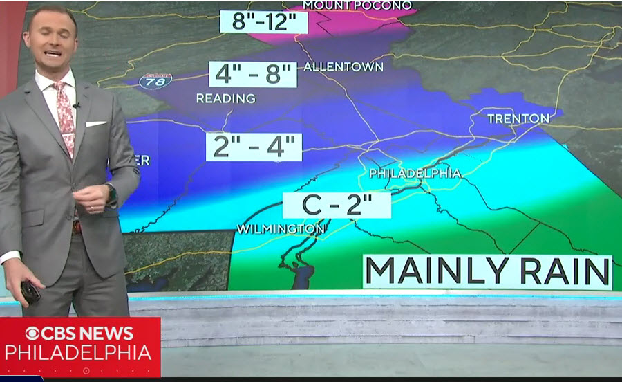
They all do Delaware County Coating to 3" honsetly though this is really tough but don't blame the lower totals with ground temps but dynamics can overcome and that is what this storm will be all about dynamics with heavy rates.
-
2 minutes ago, Duca892 said:
Hi can this please stop trending S/E. Thanks.... starting to sweat a little bit even here in the LV. Still hoping for a classic 6-10in
Yep this is also NOT one of those situations where snow ratios less liquid further north will help you. In order to get the heaviest snow you MUST BE in the heaviest corridor of moisture banding. This could be a rate dependent snow that can flip from snow to rain back to rain depending on rates so there is that variale too.
I think if I am forecasting for SE pa like here in Media Delaware County I would call for 3-5" or so.
-
6 minutes ago, ChescoWx said:
While rates can overcome marginal temps and warm grounds....this could well be a classic case of elevation playing havoc with totals. I have seen 6" of snow at my spot and drive 1 mile away down 250 ft and only see 3" of snow with a temp at 32-33
I am 100% in your camp. Literally where I live I could have 9" at my house half mile away drop 100 feet be at 3" I get you.
-
4 minutes ago, Ralph Wiggum said:
Hrrr looks 83ish with that band and those rates down this way. Ffs make this the one time it verifies lol
I was 9 years old in that storm in 1983, but I think this is a wee bit different set up. This trend here is unprecidented, fun, unexpected but the temps???
-
3 minutes ago, Duca892 said:
how much stock should one put in the EURO at this range? is this the only model showing this solution at this point?
Ukie kind of looks like it think we are on to the short range dynamical models now. Euro and Ukie cannot be discounted.
-
Just now, ChescoWx said:
Euro goes SE

This forecast is going to be VERY Tricky at very short leads wow!
-
NAM seems reasonable think it may be accounting for the cold air crashing and also elevation. I am very interested to see what the GFS says, but honestly it is time for short range dynamic models. Anymore shifts to the SE and region wide north and west of the Delaware River gets pasted. What is tricky in this situation you cannot salt the roads in the rain and this is CLEARLY a rain to snow event.
The rain snow line will be monitored like a hawk! The earlier the changeover the more snow you get I would think in this case.
-
14 minutes ago, Ralph Wiggum said:
NAM 12k snow depth has a slushy inch or so up here. Meh.
NAM big step back compared to 18z run.
-
Looking at the water vapor map pretty good push moving SE pretty quickly from Winnepeg through Minnesota heading for the Great Lakes. I wonder if this scoots our storm a bit further south and east.
-
NAM and dynamical models tonight will be telling at 0z wow!
-
Umm I am NOT ignoring the trend on the NAM clearly more south and a bit stronger!
That is from the NAM an undeniable switch to heavy snow just after 6 am in Delaware County.
-
39 minutes ago, Stormchaserchuck1 said:
Major trough in the NW on LR 12z GEFS.. that's been the Spring pattern lately.
But we haven't begun the best winter pattern in like almost 10 years?
-
 1
1
-
 1
1
-
-
Just now, RedSky said:
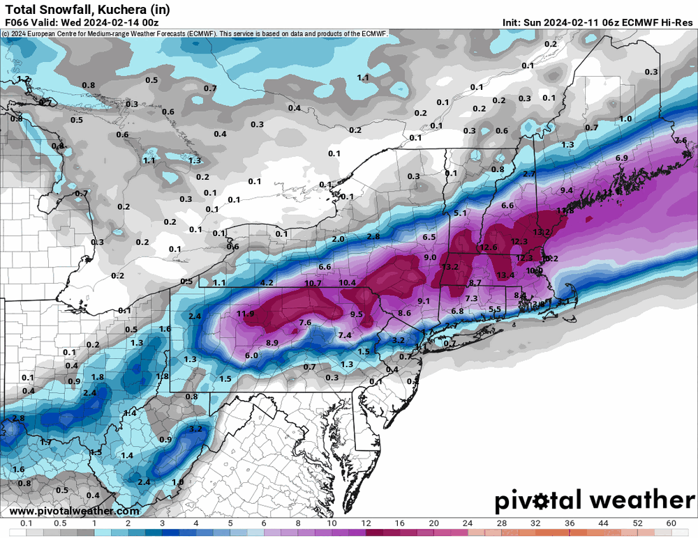
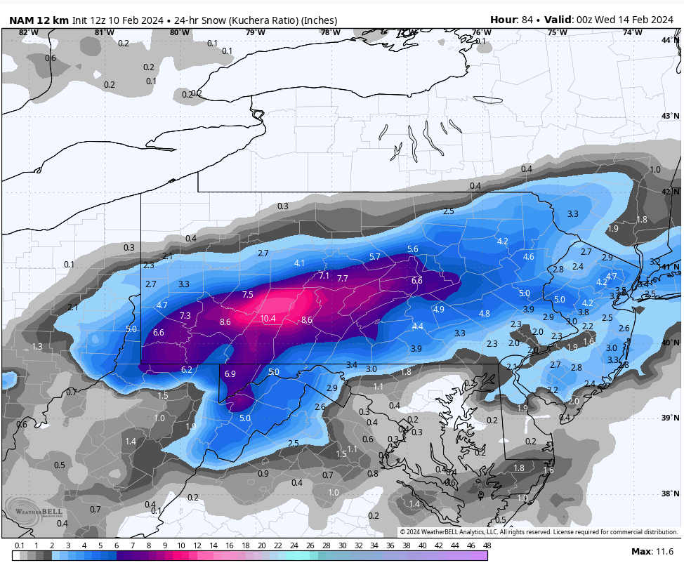
Taking a hyper technical mathematical look at the euro kuchera clown map I get...3.8" same as the January storm lol
Looked like the GFS ticked south a tad too.
I am guessing the Euro shows about 1.7" here in Media haven't looked at it.
-
2 hours ago, Hurricane Agnes said:
6z hi-res Euro.
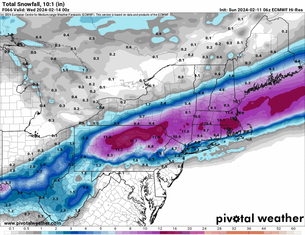
LoL right where Bernie Rayno said it would be like perfect. Also north of the turnpike? Better drive another 2 hours.
-
6 hours ago, Fields27 said:
NAM held. Plowable snow from about the turnpike on North.
Edit: Definitely shifted N with the axis of heavier snow. C and NE Jersey get the shaft.
Sent from my SM-N975U using Tapatalk
Ummm yes plowable on the grass. Good luck on paved surfaces.
-
7 minutes ago, Fields27 said:
GFS even further N. When will the bleeding stop?
Sent from my SM-N975U using Tapatalk
No worries Dr. Yes will save us in the Ukie I trust! 10-12" or go home!
-
33 minutes ago, ChescoWx said:

Nam ED!
-
The long range is evaporating for snow chances. I see the same old theme being played out a lack of cold high-pressure systems.
I dare say it may be time to pack up the season soon at least we got 9.6" this year in Media instead of the 1.7" we got this year so victory, I guess!
Rain to Snow early Tuesday Morning I am expecting speckles of white on the grass maybe?
Total snowfall in Media from this storm 0.4"
-
6 minutes ago, RedSky said:
Anybody seen the Ukie? It's a snow bomb with heaviest snow to the south haha
I am going with the Ukie and ignoring all other model guidance it is correct! As Mando says, "This is the way!"
-
1
-
1
-
-
34 minutes ago, ChescoWx said:

Souther maybe but end result not much different clearly temp issues. I think this may not be too far off from reality think you can shave a lot of that in south Jersey away though.
-
The Euro run tonight will be rather interesting to see which way this goes.
-
51 minutes ago, RedSky said:
CMC gives ya 6" or 3" with kuchera ratios
I would take that in a heart beat!
-
1
-
-
2 minutes ago, RedSky said:
GFS with 1.5" to 12" in Bucks with the 10:1. Nothing's changed the region sits precarious on the thin red line this winters MO
nice 0.7" for Media
-
29 minutes ago, ChescoWx said:
I am a big Bernie Rayno fan...he just said he is going against the current Accu Weather snow maps and believes there will be no snow at all in SE PA nada too warm. Says models will indeed come north this weekend and AccuWeather and others will shift their accumulating snow forecasts northbound.
Well that would go back to the original solution where New England wins. I mean that is a dramatic Shift back and forth.


2/13 rain to snow event
in Philadelphia Region
Posted
Snow maps still the same?