

Kevin Reilly
-
Posts
2,154 -
Joined
-
Last visited
Content Type
Profiles
Blogs
Forums
American Weather
Media Demo
Store
Gallery
Posts posted by Kevin Reilly
-
-
JB still thinking snowstorm on Tuesday? Would love to hear his analysis on the upcoming event or may I say nonevent. I guess he is waiting to be saved by the Euro at 0z.
-
So far this storm is overhyped it is very underwhelming just some light steady rain and the wind is a complete dud maybe I had a gust to like 25 mph at best so far. This whole dam thing sucks. Something has to give I mean it's below zero out west now.
-
 2
2
-
-
5 minutes ago, Deck Pic said:


There are no words that can explain how we got here no words! How do you have all that below zero air poised to come down into the lower 48 have below zero air in the lower 48 and get no storm along the gulf and Atlantic of any substance makes no sense.
-
1
-
-
2 hours ago, Weather Will said:
And I'm sure it will make everyone feel better to know that JB still thinks the storm is coming on Tuesday in his evening WB video.
JB still thinks last weekend's storm is still coming! Ratings Raitings ratings.
-
 1
1
-
-
2 hours ago, TSSN+ said:
Ok Euro time to get with it
I think looking at the UKIE, ICON, and GFS it is clear to me that the Euro is in its bias of holding energy or not handeling it correctly out west. Typically this happens in the southwestern United States though.
-
1
-
-
1 minute ago, Stormchaserchuck1 said:
If it hangs back later, we might be able to do a stronger storm, because that piece of the Polar Jet is rotating SW in Canada
This makes the most sense to me establishing just the right block typical stuff around here if you ask me.
-
2 minutes ago, baltosquid said:
Coastal development has me intrigued, though getting it to pop in the right place is a toughie.
way
hmmm what is with the 300 mile jump back west to the coast. This run is wonky and clearly is confused and missing something. 997 way out then moves 300 miles west to 992 then bombs away to 979 to 970 something is amiss here. I am willing to bet data is missing somewhere and or there is clear confusion with the storm tomorrow night into Saturday.
-
2 minutes ago, TSSN+ said:

It's reliving last weekend!
-
2 minutes ago, NorthArlington101 said:

Umm how much snow did we get last year??? Take it and run for the HILLS!
-
2
-
-
1 minute ago, TSSN+ said:
Meanwhile cmc is well nw
Split the difference BOOM!
-
1 minute ago, Stormchaserchuck1 said:
0z RGEM vs 18z GFS is similar to 0z NAM vs 18z gfs.. flatter trough, but hanging more energy back in the west.
So, one of those does all the energy come out of the west or just small pieces come east one at a time done this drill again and again in the past. These are some of the trickiest things for models to handle at around Day 4. I really don't think we know much of anything until Saturday night or so.
-
1
-
-
Just now, Terpeast said:
Icon move its slp position 500 miles to the SE, lol
I told you guys we shouldn’t be starting a thread until like Saturday
At this rate you may not need a thread.
-
1
-
 1
1
-
 1
1
-
-
1 minute ago, clskinsfan said:
ICON is squashed as a mofo. Still a long ways to go.
Yea looks just like January 1996 WTF!
-
2
-
-
36 minutes ago, paulythegun said:
slight NW trend, more intense
I think the wiggle back and forth is 100% tied to the Friday into Saturday storm. It all depends on where the baroclinic zone sets up off the coast. I feel we will not know this until tomorrow night into Saturday PM.
-
38 minutes ago, NorthArlington101 said:

Hmm ratios would push this higher no?
-
54 minutes ago, stormtracker said:
6-8 area wide...and I mean AREA wide from HGR down to cape
sure about that colder = more = ratios
-
1 hour ago, CAPE said:
Latest NBM

This model has been very good now let's see how it does tranitioning from warm and wet to cold and snowy!
-
Just now, NorthArlington101 said:
the slowest 1-2” ever, but we technically get thereIt will correct in time it's really 1-2'.
-
Sky is lightning up here orange and blue and red not sure what is going on. This is off to my east. Maybe a tree came down and there are power explosions in the general direction of Springfield Delaware County. There is some wind out there but I don't think enough to bring power lines or trees down so maybe a loose tree came down don't know?
-
16 minutes ago, WEATHER53 said:
This was the depiction for the early Jan event about 4/5?days before we got rain and 50. I hit really excited about an A but turned out further north and west, stronger with excellent cold air scooting out in 24 hours and thus temps over 20 degrees warmer.
Yea but that event had no "real" cold air locked in and it just vanished as the high way up north quickly left this is a different scene now.
-
1
-
-
13 minutes ago, SomeguyfromTakomaPark said:
Wow great run, daytime snow, temps in the 20s. Beautiful.
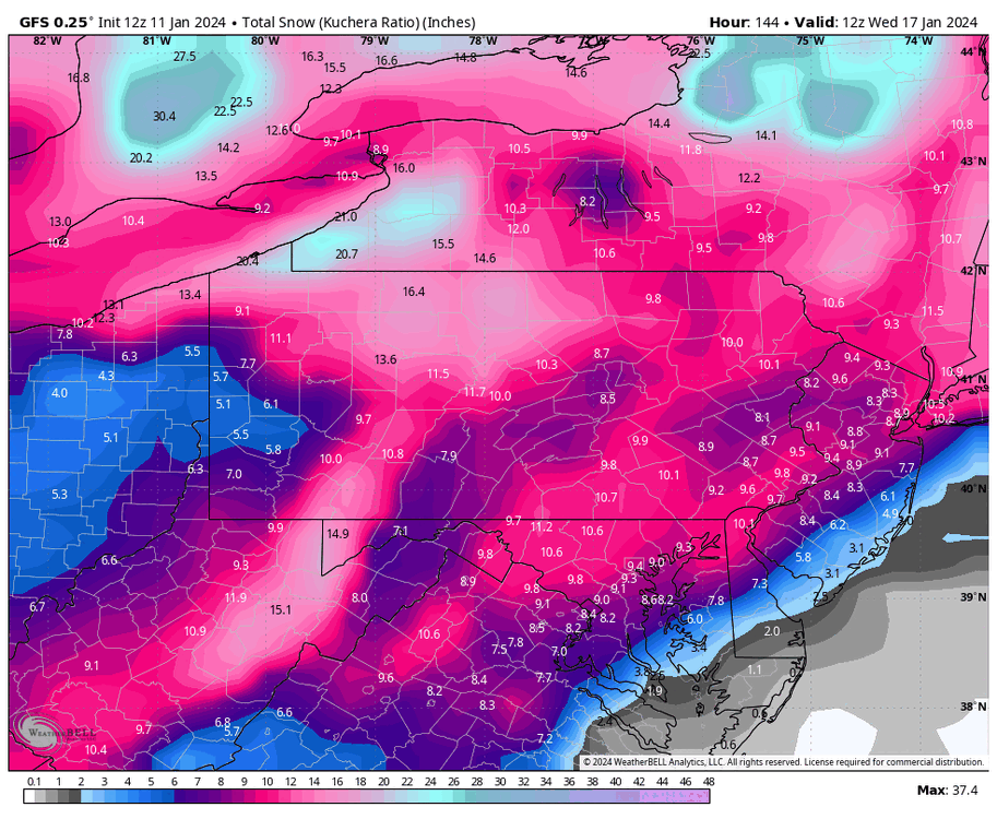
Umm while I see the totals they would be a bit higher no with a higher ratio snow so we may play that opposite game instead of the rain snow line. I think I would much rather play less liquid gets you more snow due to higher snowfall ratios with temps in the 20's and then inject more moisture later for the 1-2' snowstorm we have done this before think Presidents' Day 2003.
-
1 hour ago, baltosquid said:
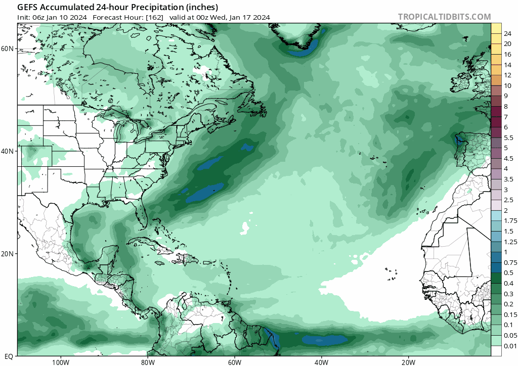
You can see the trending signature on the precip map of the storm amping up off New England. But definitely more juiced overall even before that, hopefully that trend contributes to it coming in a bit more NW over time.

Did you say we need a northwest trend around here LOL we do very well with that this final solution will be in central PA. (Edit will be right where we NEED IT!)
-
1
-
-
2 minutes ago, WinterWxLuvr said:

You forgot to put the digital blue on the maps??
-
3.02" here power stayed on went off for about 30 seconds winds gusted past 55 mph at times.

Jan Medium/Long Range Disco 2: Total Obliteration is Coming
in Mid Atlantic
Posted
Oh, the dreaded inverted trough those rarely work out, but when they do they are interesting. The last one to visit around here I think was like 2008 or so. We picked up 7" of snow while 30 miles away the skies were clear to the north with the moon out and a few passing clouds go 13 miles southeast they picked up 13" go 13 miles southwest they picked up 2". They are interesting and fun to track. Right now, we are looking for anything that will work at this point and an inverted trough is an interesting one.