

Kevin Reilly
-
Posts
2,960 -
Joined
-
Last visited
Content Type
Profiles
Blogs
Forums
American Weather
Media Demo
Store
Gallery
Posts posted by Kevin Reilly
-
-
Just now, winter_warlock said:
Damn.. looks alot better for us all. Its a shame the ICON isnt a more reliable model lol
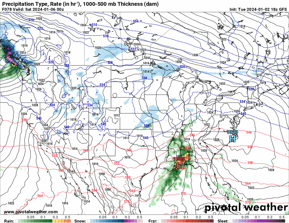
It will be on Thursday when it shows .50" to 1.00" of rain.. just kidding seriously Thursday 0z
-
 1
1
-
-
if you are looking for a KU system this is not the storm. I totally agree with that, but something also tells me that this storm is not a nothing.
I just have a feeling with these wild swings in modeling last 15 hours that there is data missing whether it be with the northern stream system, southern stream system, or the placement and modeling of the high to the north.
My gut tells me that starting with 0z tonight and going out to 6z Thursday the weekend event's actual potential comes into view, and we see some positive changes for snow possibilities.
My gut tells me that this is a 3-6" / 4-8" from Washington Dc, Baltimore to Philadelphia to NYC points north and west. I think the further south and east you go it drops off pretty quick to 1-3" then 1" 45 miles from the coast and zero along the coast.
Just my thinking right now.
-
I think Bob Chill said last night if you are looking for a KU system this is not the storm. I totally agree with that, but something also tells me that this storm is not a nothing.
I just have a feeling with these wild swings in modeling last 15 hours that there is data missing whether it be with the northern stream system, southern stream system, or the placement and modeling of the high to the north.
My gut tells me that starting with 0z tonight and going out to 6z Thursday the weekend event's actual potential comes into view, and we see some positive changes for snow possibilities.
My gut tells me that this is a 3-6" / 4-8" from Washington Dc, Baltimore to Philadelphia to NYC points north and west. I think the further south and east you go it drops off pretty quick to 1-3" then 1" 45 miles from the coast and zero along the coast.
Just my thinking right now.
-
5
-
 1
1
-
-
40 minutes ago, Hurricane Agnes said:
The models need data from when a PAC system finally comes ashore into California - I think expected within the next 12 hours or so (based on the HPC surface forecast).
Yes, I do remember this point! I should have known back where models have storm lose it then bring it back 3-4 days prior typical scene. The swings are just so wild. I will say this if the models come back around again to 10-15" they will lock in.
-
 2
2
-
-
56 minutes ago, Hurricane Agnes said:
18z GFS ditches all-inland Miller-B type thing and coast hugs (edit - still wants a low to do a jump though).
What the hell is going on here these runs are getting laughable. The low is jumping all over the place. I have ever seen this before which low is the real storm??? It is clear to me at 18z the models are having significant issues dealing with the northern and southern streams here and whether to phase or not to phase.
-
4 hours ago, RedSky said:
Just think you got cold rain followed up by a big mild rain to stoke the daffodils
Yea, sorry the daffodils are already up along with my crocuses.
-
The trend is very clear last 12 hours north closer to coast weaker storm. I give to 0z tomorrow night. Bring on Euro!
-
1
-
-
5 minutes ago, MillvilleWx said:
NBM continues to be impressive at leads with the mean QPF and snowfall forecast. Odds are increasing of 1-1.5” QPF during the time frame of the storm, so you can deduce some average ratios of 7-8:1 to as high as 12-14:1 during the storm height within any banding. A pretty good indication of 6-10+” is on the table if all things break correctly.
In-situ cold will be great leading in with drier dew points. That should aid in wet bulbing on the initial surge of low-mid level moisture that’s accustomed to these events. Good trends overall.
Without a doubt look at the water vapor map.... check out Mexico the Southern Jet is ready!!
Pennsylvania Water Vapor Satellite Weather Map | AccuWeather
-
3 minutes ago, Albedoman said:
for shitz and giggle Old Henry Margusity is throwing out this snow map. C'mon man, the storm has not even shown up on the NAM models yet

4-12" LOL quite a spread! I see he still likes Penn State!
-
 1
1
-
-
32 minutes ago, Terpeast said:
We've been looking at how this is trending, too. It has trended colder with a stronger high up north. I've been harping on this for 2 days now.
This idea is something new that has been missing going on 3 years now. Welcome Back!!
-
50 minutes ago, Terpeast said:
Cold high location exactly the same the last 3 runs, remarkable consistency
The Big Storms Lock in Early!
-
1 hour ago, Terpeast said:
I was telling psuhoffman the other day that if we got to January 1 and there was nothing noteworthy as a threat in the next 15 days, I would downgrade my snowfall forecast for the entire area by about 25%.
Here we are, it's Jan 1 and we're tracking a threat that just might pan out for us. Not planning on any changes to my outlook until after the 1/7 event passes, then I will reassess from there. Downgrade may still happen if we go all rain in the low lands, which is not off the table yet.
Honestly up here in the northern Mid-Atlantic in my winter weather outlooks I do not retool until January 20th each year that is my magic date. This year I was going for 20-35" in Central Delaware County in Extreme SE PA.
-
34 minutes ago, brooklynwx99 said:
i would be remiss to not mention this. this is a legit KU level block. 3 sigma at 12 days out is insane
T
Thye need to fly baby fly! All the way to Georgia and Florida! They know! Now the squirrels are going ape shit to stock up on nuts.

-
2
-
3
-
-
18 minutes ago, RedSky said:
Euro, Ukie and Icon north. GFS crashed at times square with too many layers of rum way south.
split the difference, but you forgot the Canadian.
-
1
-
-
5 minutes ago, Birds~69 said:
Squirrels making weird-ass noises in the trees today to add to the "they know" theory..."click-click" and a "whining" sound.
Overcast/42F
Yep, I have seen them gathering nuts at a feverish pitch.
How about the Commanders and Dallas game Sunday? Dallas might try to move the dam game lol, right?
Also, mother nature loves January 7th and 8th during football season when it comes to snow.
-
I am sure this is going to bounce around a bit, but at least we have something to track. I will keep my expectations in check.
-
1
-
-
34 minutes ago, Ralph Wiggum said:
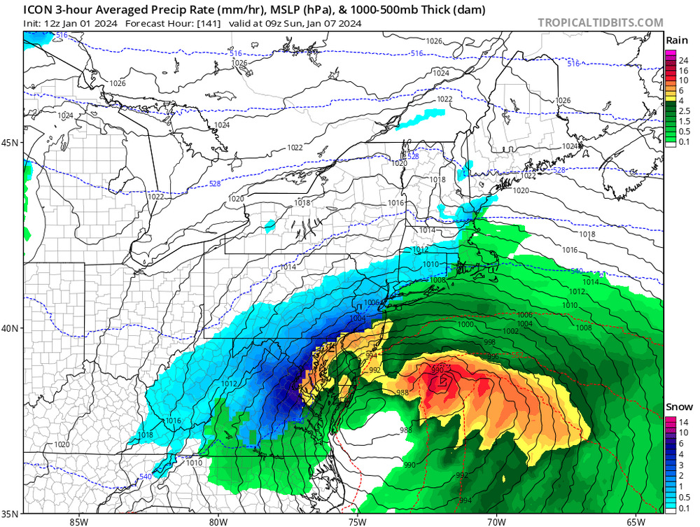
ICON says game-on. SE PA buried:
They know!

-
1
-
-
Dynamically speaking we have to rank March 13, 1993, somewhere I feel. Storm Surge on the Gulf Coast West Coast. Over a foot of snow down in Brimingham Alabama and 16" of snow followed by 5" of sleet and a rainbow at the end. That was an interesting storm it was like 56 degrees the day before and when it started snowing winds were NNE gusting to like 35 mph and it started snowing at 40 degrees.
-
4
-
-
2 minutes ago, Ralph Wiggum said:
Lightning and thundersnow....4-5"/hr rates for 1.5-2.5 hrs. Unreal stuff man.
Yea I was 9 years old and living in Philadelphia at the time the north side of the alley way had like 2" of snow down and the south side of the driveway had 5-7 feet of snow. We got 22.5". Yes, thunder and lightning with heavy snow with graupel mixed the wind was pretty significant too probably was gusting past 40 mph. After the storm left the next day, it was pretty warm.
-
1
-
-
2 minutes ago, Snowchaser said:
Did anyone see the 18z NAM?

That's what we call a southern slider exiting stage left. No Geese!
-
1
-
-
Looking to next Sunday we have some NFL action possibly in the snow:
1. Dallas at Washington
2. Eagles at New York
May get to see a snow game?
-
4
-
2
-
-
5 minutes ago, Ralph Wiggum said:
"18Z gfs stopped the bleeding"

0z This Guy will be back!!! I am telling you they know. They just gave some fodder to the GEFS for more confluence just waiting for the other flocks to leave up north.
-
1
-
9
-
-
2 minutes ago, WEATHER53 said:
Shows6+ hours of snow in DC. How is that a trend of no snow?
I think that is more hours of snow than we had all of last year! Victory! They Know!
-
1
-
-
1 hour ago, psuhoffman said:
On the positive side if this goes sideways at least we won’t have to hear all the complaining when the snow gets washed away 2 days later by the cutter.
That actually happens often!
-
1
-

January 6-7 Storm Discussion: we’re due?
in Mid Atlantic
Posted
hmmm sampling anyone.. just raked up a bunch of crap from the Geese.