


GaWx
-
Posts
19,894 -
Joined
Content Type
Profiles
Blogs
Forums
American Weather
Media Demo
Store
Gallery
Everything posted by GaWx
-
Other than 4-5PM on Friday (due to monsoon, not Hilary), LV has had fairly light hourly rain rates for the most part to this point. Due to the continuous nature of the rain over many hours, rain amounts have been heavy for LV relative to climo. On Friday 8/18, they received 0.30". But that was due to the monsoon flow rather than Hilary. This was the third heaviest on record for the date (back to 1937). Looking more closely, it appears that they got ~0.26" 4-5PM on 8/18, which is quite heavy for just one hour. Edit: That is the heaviest hourly rainfall since at least 8/11/2022. Yesterday 8/19 they got 0.21", which was largely from Hilary and was a record for the date as the old record was 0.18" (2003). Also, their high was only 79, a record low high that was 24 BN. Old record was 81 (2003). So far today, they have received ~0.10", which already has broken the record for today. The old record had been 0.06" (1975). So, for the period since Friday, LV has already received ~0.61" due to a combo of the monsoon and Hilary (near even split) with quite a bit more expected today from Hilary. The three day period 8/18-20 averaged only 0.02" during the period 1937-2022.
-
-I have Aug JMA for DJF 22-23 -0.43 vs actual -0.67 for a miss of +0.24 -I have Aug JMA for DJF 21-22 -0.16 vs actual -0.97 for a miss of +0.81 (but admittedly still a big error) During last 10 years: -Avg Aug JMA miss when DJF <-0.5: +0.5 -Avg Aug JMA miss when DJF >-0.5: -0.2 If we were in/headed for another La Niña, I'd lean to this last JMA run being too warm. And it of course may be. But with it not La Niña and with all 7 major models now +2.0+, it is hard for me to lean that way considering the recent non-La Niña years as well as how earlier months this year have gone. So, I'm neutral on its latest of +2.18 for DJF, especially with it rising so much even with a much cooler OHC in July and only a tepid 3.4 SST rise in June/July.
-
-But those forecasts were made in April -August JMA forecast miss for DJF ONI last 10 years: avg +0.1; -average dynamic models Aug miss for DJF ONI last 10 years +0.3 -the same but for last 7 El Niños alone: JMA -0.1; avg dyn: 0
-
The Meteo-France has been similar to AUS on being much too warm. I expect they'll both verify significantly too warm for peak. That July Euro will clearly verify much too warm for Aug and it does have a warm bias. Their May forecasts for peak ONI (whether - or +) have not verified too cool since way back in 2004! The model run that has recently had the biggest impact is the JMA's warming from +1.76 to +2.2. The JMA had recently been lauded ITT as one that has done well. I then analyzed how it had done earlier this year and found it to not be warm biased and instead slightly cool with averaging a -0.1 miss for the subsequent month and a -0.3 miss for several months out.
-
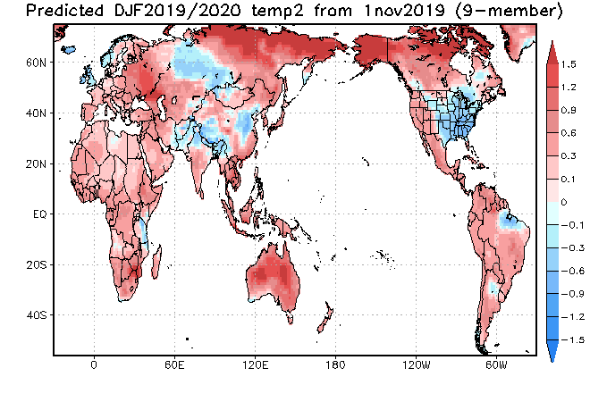
I became curious about 19-20 after reading this. So, I checked the 19-20 threads and found that nearly every forecast ended up verifying much too cold. I'm placing some of the blame on some seasonal model forecasts that were much too cold. For example: -JAMSTEC (11/1/19) a pure disaster (I think it is cold biased in the E US because it has had cold forecasts there for a good # of winters that ended up mild) -But this C3S was actually not bad though it wasn't warm enough: -The CFS and CANSIPS maps were ~normal. -The forecasters largely went near normal to slightly colder than normal. The consensus among them was a neutral to -NAO, possibly influenced by the strong -NAO (-1.6) (second strongest -NAO on record) for May-Oct 2019. NAO ended up sharply reversing to strong +NAO all 3 of DJF. -Though even he verified too cold, Don Sutherland did the best of those that I saw with no BN anywhere in US. He had near normal Desert SW/Great Lakes/NE and slightly AN most other areas other than solidly AN SE. The key to him not missing by as much: he predicted a +NAO. -If Don were to go -NAO this winter, that would be quite encouraging because historical stats show no correlation of a -NAO summer to -NAO following winter.
-
The relatively cool OHC is the main thing keeping me from going higher than 70% chance for a +2.0+ ONI peak. But I don't think ENSO SST forecasts overall are showing "excessive momentum" because the latest major ones outside of the already very warm BoM and Meteo-France substantially warmed from the prior month despite a tepid June-July 3.4 warming/~neutral SOI/big OHC drop. Also, the JMA, CFS, CANSIPS, and UKMET all actually had cooled the prior month.
-
Also, 2.58" is the heaviest for any date of the year. And their second heaviest daily record for any date of the year occurred on the very next date, 8/22! (1.65") The record high two cal. day record is 2.59". That may be in danger.
-
Although I'm not saying they can't end up with a dangerous situation then, I'd say that the worry regarding the 12Z GFS would be the case for folks not realizing that the exact 10 day position on the GFS or really on any operational for that matter is of very limited forecasting value since they jump around a lot that far out from run to run. Regarding GFS runs over the last 5 days, only the 0Z 8/16 run has anything similar.
-
Those diagrams suggest a transition from east based in OND to a cross between east based and central based DJF.
-
Though it still has no GOM TC, the 12Z UKMET continues to have E MDR TCG from a non-tagged AEW next week: NEW TROPICAL CYCLONE FORECAST TO DEVELOP AFTER 126 HOURS FORECAST POSITION AT T+126 : 14.5N 18.4W LEAD CENTRAL MAXIMUM WIND VERIFYING TIME TIME POSITION PRESSURE (MB) SPEED (KNOTS) -------------- ---- -------- ------------- ------------- 0000UTC 24.08.2023 132 14.7N 19.2W 1004 30 1200UTC 24.08.2023 144 15.8N 22.1W 1003 35 0000UTC 25.08.2023 156 17.0N 25.5W 1005 37 1200UTC 25.08.2023 168 17.6N 28.4W 1005 35
-
Per today's monthly summary of dynamic models: 1. Most recent CANSIPS is confirmed to be at +2.05 ONI peak OND vs +1.61 a month ago. 2. New UKMET now up to +2.00 NDJ. 3. The ONI peak from the average of all dynamic models has risen from +1.81 last month (OND) to +2.06 (NDJ). 4. DJF has risen from +1.50 to +1.91. 5. Based on the new UKMET also being super, I'm raising the chance for super ONI peak from 60% to 70%. It is still far from a lock largely because of OHC at last check only in the +0.80s though I expect it to rise substantially in the coming months. https://iri.columbia.edu/our-expertise/climate/forecasts/enso/current/?enso_tab=enso-sst_table
-
8/18/23 like night and day vs 8/18/22 in MDR: 8/18/22 2AM EDT TWO: 8/18/23 2AM EDT TWO: SEVEN features have significant activity on the 0Z EPS just through day 10! That almost has to be near a record:
-
Indeed! Per official LV records that go back to 1937, the heaviest two consecutive calendar day rainfall on record is 2.59" that fell August 20-21, 1957. That was also during an oncoming strong El Niño, coincidence or not. Next was the 2.10" of 12/28-9/2004 (weak El Niño). The 3rd heaviest was August 21-22, 2012 (warm neutral ENSO), when 2.03" fell. So, 2 of the 3 heaviest were during August 20-22. The upcoming heavy rain threat looks to be centered on August 20-21!
-
Once again, the UKMET has no GOM TC. But for the 4th run in a row, it has TCG late in the run in the far E MDR: NEW TROPICAL CYCLONE FORECAST TO DEVELOP AFTER 150 HOURS FORECAST POSITION AT T+150 : 12.7N 17.2W LEAD CENTRAL MAXIMUM WIND VERIFYING TIME TIME POSITION PRESSURE (MB) SPEED (KNOTS) -------------- ---- -------- ------------- ------------- 0000UTC 24.08.2023 156 13.7N 18.3W 1004 32 1200UTC 24.08.2023 168 15.0N 21.3W 1005 30
-
12Z UKMET...This appears to be from 99L. It forms and dissipates within the Caribbean: NEW TROPICAL CYCLONE FORECAST TO DEVELOP AFTER 126 HOURS FORECAST POSITION AT T+126 : 15.3N 72.4W LEAD CENTRAL MAXIMUM WIND VERIFYING TIME TIME POSITION PRESSURE (MB) SPEED (KNOTS) -------------- ---- -------- ------------- ------------- 0000UTC 23.08.2023 132 15.7N 73.1W 1003 32 1200UTC 23.08.2023 144 16.6N 73.6W 1005 33 0000UTC 24.08.2023 156 17.1N 74.3W 1006 28 1200UTC 24.08.2023 168 CEASED TRACKING Edit: Upon further review, this may be from a feature west of 99L.
-
The 0Z EPS just through day 10 is very busy with many active members for 98L, 99L, the Gulf low, and two followup MDR AEWs. Also, late in the run there are ~half the members moving up from the Bay of Campeche with some members crossing over from the Pacific late in the run. So, that's a total of six different features of interest just through day 10. Thus if only half of these end up as a TC, that would be enough to yield three new TCs by 0Z on 8/27 (very busy vs climo averages for just a ten day period). That's like night and day vs what the models showed for the same part of August last year. Two of these six (the two in the Gulf) would be direct threats to the CONUS. I originally predicted 3 NS for August. I feel pretty good about that prediction.
-
Though the 0Z UKMET still has no GOM TC, it for the third time in a row has a TD form in the far E MDR at the end of its run: NEW TROPICAL CYCLONE FORECAST TO DEVELOP AFTER 168 HOURS FORECAST POSITION AT T+168 : 14.2N 17.6W LEAD CENTRAL MAXIMUM WIND VERIFYING TIME TIME POSITION PRESSURE (MB) SPEED (KNOTS) -------------- ---- -------- ------------- ------------- 0000UTC 24.08.2023 168 14.2N 17.6W 1004 34
-
Regarding the mid/MDR tangerine, which has become Invest 99L: TWO: now up to 40%/60% 0Z UKMET: yet again a TS in the Leewards, but this run then has it go NNW and later NNE track that aims well to the E of Bermuda: NEW TROPICAL CYCLONE FORECAST TO DEVELOP AFTER 84 HOURS FORECAST POSITION AT T+ 84 : 16.9N 58.9W LEAD CENTRAL MAXIMUM WIND VERIFYING TIME TIME POSITION PRESSURE (MB) SPEED (KNOTS) -------------- ---- -------- ------------- ------------- 1200UTC 20.08.2023 84 16.9N 58.9W 1006 28 0000UTC 21.08.2023 96 17.6N 60.3W 1005 34 1200UTC 21.08.2023 108 19.2N 60.9W 1005 42 0000UTC 22.08.2023 120 20.2N 61.4W 1003 39 1200UTC 22.08.2023 132 22.0N 61.8W 1003 44 0000UTC 23.08.2023 144 23.8N 62.3W 1004 35 1200UTC 23.08.2023 156 25.6N 61.8W 1005 31 0000UTC 24.08.2023 168 26.9N 60.9W 1004 27
-
Lol, I was just looking at today's updated SSTs so I could do an update. Yeah, CRW has consistently been the warmest. But even OISST 3.4 has just gone past +1.3 for the first time. That implies that ERSST is likely ~+1.2. OISST 3 is also at its warmest and is approaching +2.0.
-
Thanks. In Swain's article, he says: "climate change–which is likely increasing the duration and severity of droughts on the lee sides of the islands and the intensity of wet-dry cycling of precipitation (which favors extra vegetation growth, and then rapid drying of that extra growth during high risk periods)." Then you restated Swain's idea of wetter wet seasons and drier dry seasons. But then I read this from your last link about expected changes on Hawaii, itself, due to CC written by Kevin Hamilton: "We found that in the wet windward areas of Hawaii, rainfall is projected to increase substantially. That includes increasingly frequent extreme downpours. On the other hand, rainfall is predicted to decrease substantially over much of the rain shadow regions." ----------- So, to recap, Swain is suggesting wetter wet seasons and drier dry seasons. But Hamilton is instead suggesting wetter windward areas and drier leeward areas. So, Swain implies CC causes Lahaina to have both wetter winters (causing increased vegetation) and drier summers (causing more fire danger due to more fuel available that dries out in summer). But Hamilton is implying CC causes both winter and summer to be drier at Lahaina. So, per Hamilton, there actually isn't the increased fuel at Lahaina due to wetter winters. So, Swain (wetter) and Hamilton (drier) are literally on opposite sides on how CC affects Lahaina winter rainfall. Any thoughts about this? Doesn't it concern you? Thanks.
-
1. The 12Z UKMET is similar to the prior run with a new TC in the far E MDR at 168: NEW TROPICAL CYCLONE FORECAST TO DEVELOP AFTER 168 HOURS FORECAST POSITION AT T+168 : 12.1N 20.3W LEAD CENTRAL MAXIMUM WIND VERIFYING TIME TIME POSITION PRESSURE (MB) SPEED (KNOTS) -------------- ---- -------- ------------- ------------- 1200UTC 23.08.2023 168 12.1N 20.3W 1006 30 2. The UKMET still has no TC in the Gulf.
-
Regarding the central MDR lemon, the 12Z UKMET again develops this into a TS. It hits the Leewards to PR followed by a recurve E of the Bahamas to a position that could later threaten Bermuda: NEW TROPICAL CYCLONE FORECAST TO DEVELOP AFTER 90 HOURS FORECAST POSITION AT T+ 90 : 16.2N 59.1W LEAD CENTRAL MAXIMUM WIND VERIFYING TIME TIME POSITION PRESSURE (MB) SPEED (KNOTS) -------------- ---- -------- ------------- ------------- 1200UTC 20.08.2023 96 16.7N 60.2W 1005 34 0000UTC 21.08.2023 108 17.3N 62.1W 1005 35 1200UTC 21.08.2023 120 18.4N 64.4W 1004 36 0000UTC 22.08.2023 132 19.8N 65.4W 1004 40 1200UTC 22.08.2023 144 21.2N 67.5W 1004 45 0000UTC 23.08.2023 156 22.2N 67.5W 1003 41 1200UTC 23.08.2023 168 24.5N 68.2W 1004 40
-
What do you mean by "wet/dry season cycling" and how does that relate to increased CO2? Thank you in advance.
-
1. The overall magnitude of SAL is about to sharply decrease, which largely matches the typical decrease in mid August and is one of the main reasons that there is a climatologically sharp increase in activity in late August. 2. One of the typical effects of a moderate+ El Niño is overall increased Caribbean shear coming in from the west. However, to this point overall, that has yet to take place. Of course, that may start dominating at any point as El Niño strengthens.
-
The 0Z UKMET has a new TS form in the far E MDR in a week moving WNW: NEW TROPICAL CYCLONE FORECAST TO DEVELOP AFTER 156 HOURS FORECAST POSITION AT T+156 : 10.5N 16.9W LEAD CENTRAL MAXIMUM WIND VERIFYING TIME TIME POSITION PRESSURE (MB) SPEED (KNOTS) -------------- ---- -------- ------------- ------------- 1200UTC 22.08.2023 156 10.5N 16.9W 1006 28 0000UTC 23.08.2023 168 11.1N 19.4W 1006 35

