

GaWx
-
Posts
15,994 -
Joined
Content Type
Profiles
Blogs
Forums
American Weather
Media Demo
Store
Gallery
Posts posted by GaWx
-
-
The 12Z EPS mean has increased from about nothing to very light snow that is near the 12Z GEFS amounts in NC:

But the EPS mean temp anom map doesn’t even have a Barney Rubble! Looks more like a Pebbles Flintstone. Good luck with that in March:

-
12Z Euro fwiw has a little snow on Mar 9 outside of the mtns in NW SC/SC NC:

This is at the far N end of the qpf:

It has just a mini-Barney (Barney Rubble?) during a time of year that daddy-Barney may be needed as one of our posters previously sort of put it:

-
 2
2
-
-
1 hour ago, NorthHillsWx said:
12z GFS way different then the suppressed CMC and EURO and is an amped coastal for New England
For NC, 12Z GEFS has reverted to mainly a mountain upslope event:

Compare this to the 18Z GEFS, which had 1-2” in the Triangle/Triad. Now it is only 0.2”-0.3”.
-
12 minutes ago, Stormchaserchuck1 said:
I wish the title wasn't La Nina.. it's going to be a ENSO Neutral year/peak.
But per RONI and MEI v2 it will be an unofficial La Niña, right?
-
Feb 30 mb QBO fell to +10.55 from Jan’s +12.11 and the recent peak in Nov of +13.78. It will likely be negative by summer with very likely early autumn at the latest per historical patterns:
https://psl.noaa.gov/data/correlation/qbo.data
-
 2
2
-
-
WCS PDO just rose to -0.18 on 3/1/25, its highest daily since 3/22/24!

-
1
-
-
OHC and Nino 3.4 SSTs have recently been pretty rapidly rising with slightly warm biased CRW up to +0.086, cold biased CDAS up to -0.222, and OHC up to just above -0.6 from ~-1.25 late Jan (OISST dailies graph hasn’t been available since Jan 5th!):


-
1
-
-
KSAV (official station at airport) had a low of 32 while Hunter AAF (close to the city and not as far inland) had 34. KSAV has had an average of 1 freeze in March. That could very well end up being the last and only one. Brunswick, GA, a traditional cold spot on radiational cooling nights got down to at least 31.
The contrast between inland and coastal stations was quite large due to a lack of near calm winds on the coast, with a partial onshore component from the NNE to NE. Coastal waters temps are mainly 55-56. St. Simons only got down to the upper 40s vs Brunswick’s ~31! Charleston downtown/Harbor got down only to ~44 vs well inland CHS’s 29! Ft. Pulaski likely only got down to ~49 and possibly as high as 50 vs Hunter’s 34 and KSAV’s 32! Sapelo Island, one of the traditionally colder island locations got at least down to 41.
-
 1
1
-
-
0Z GEFS 10:1 24 hour snow: lower amounts vs 18Z GEFS but still decent signal

-
2
-
-
6 hours ago, ncjoaquin said:
It will be gone at 0z, but I will throw it on here to break the silence.
 5 hours ago, BornAgain13 said:
18z GEFS really bumped up for next Sunday. Probably will be gone by 0z though.
Not gone at 0Z. Still there and similar:

-
1
-
-
6 hours ago, Stormchaserchuck1 said:
Here was the GFS
The 0Z 3/2/25 GFS/GEPS had a min of -21 on 3/12 and 3/13, respectively. 0Z GEFS had -17 on 3/13 with 100% of members having a reversal to -5 or lower. And the 0Z Euro had -18 on 3/13 as we know. So, it is unanimous for a substantial reversal.
-
1 hour ago, BornAgain13 said:
18z GEFS really bumped up for next Sunday. Probably will be gone by 0z though.
Yeah, 18Z GEFS strongly for an ensemble mean followed the 18Z GFS fwiw (thus I don’t expect this to hold up on the 0Z):

-
1
-
-
1 hour ago, Maestrobjwa said:
Might wanna put this in the other thread.
I already posted the link there yesterday after seeing it here. Andy H being fired was kind of a shock.
-
1
-
-
On 3/1/2025 at 7:53 PM, GaWx said:
Ready or not it is now evident that either a major SSW or a very early FW is very likely on the way within ~10 days. This (today’s Euro Weeklies) shows ~95 of 100 members reversing by Mar 14th. The mean gets way down to -10 on 3/14. Today’s has the strongest signal yet. This would be consistent with Joe D’Aleo’s study showing a strong tendency for a major SSW during +QBO/strong winter solar. Solar for DJF came out to ~148:
*Edit: there’s no indication this will lead to increased snow. There’s always some chance this kind of thing will lead to BN temps in 15+ days. But as of now the models don’t even show that. Even if it were to do so, that may not mean much, if any, snow for the NE US since it will be so late in the season.
Kudos to @40/70 Benchmarkfor predicting this for some point in the late season with confidence.

Today’s Euro Weeklies mean has an even stronger reversal next week with low mean of -18 vs -10 on yesterday’s run and 100% of members having a reversal that goes at least down to -8!

-
5 hours ago, bluewave said:
The only temperatures which matter for the snow fans are on the day which the precipitation is falling. Doesn’t matter what the average winter temperature was. So unless we can get colder storm tracks in the coming years, we will continue to see this much lower snowfall pattern which began around 18-19. Hopefully, we can shift the persistent warm storm track to something more favorable for heavier snows in the coming years.
The biggest issue has been that the storm tracks have been too warm for much snow. While NYC generally has needed winter average temperatures near 32.0° for bigger seasons approaching 50” or higher, they have reached 20-30” or more with warmer winters that had cold enough storm tracks. We saw this in 15-16, 16-17, 17-18, and 20-21.
So while this winter had near average historical temperatures, the storm tracks were too warm. This lead to the average temperature for the days on which .25 or more of precipitation fell to be 41.5°. This was significantly warmer than the winter average temperature of 34.8°. So this only gave NYC 12.9” of snow.
The temperature in 86-87 also averaged 34.8°. But the average temperature on the days that .25 or more of precipitation fell was 37.0°. So the storm tracks were cold enough for 23.1” of snow on the season which was within a few inches of average.
NYC had these winters with both sub 32 F DJFs and <20” of total seasonal snowfall:
-1967-8: 19.5”
-1962-3: 16.3”
-1958-9: 13.0”
-1900-01: 9.1”
-1871-2: 14.4”
-
1
-
-
Ready or not it is now evident that either a major SSW or a very early FW is very likely on the way within ~10 days. This (today’s Euro Weeklies) shows ~95 of 100 members reversing by Mar 14th. The mean gets way down to -10 on 3/14. Today’s has the strongest signal yet. This would be consistent with Joe D’Aleo’s study showing a strong tendency for a major SSW during +QBO/strong winter solar. Solar for DJF came out to ~148:
*Edit: there’s no indication this will lead to increased snow. There’s always some chance this kind of thing will lead to BN temps in 15+ days. But as of now the models don’t even show that. Even if it were to do so, that may not mean much, if any, snow for the NE US since it will be so late in the season.
Kudos to @40/70 Benchmarkfor predicting this for some point in the late season with confidence.
-
2
-
-
New Euro Weeklies: mild to warm Mar 10th through Apr 14th
-
5
-
-
6 hours ago, wncsnow said:
Euro still says one last hurrah for the mountains
.thumb.png.3c29a5af6bbd5306d4131c65785ba5e8.png)
Here’s the 12Z Euro snowfall at 10:1 through the same time:

-
2 hours ago, nrgjeff said:
Yeah the SSW busted. Now there is talk about an MJO driven event from below, with strato reflection. That's a lot that has to go right. MJO convection is split, so I'm very skeptical.
Yesterday’s Euro Weeklies and 0Z extended GEFS (today’s not out yet) actually had the highest chances yet of any of these runs for a mid-Mar major SSW or FW fwiw:


-
2
-
-
1 hour ago, wncsnow said:
Euro still says one last hurrah for the mountains
As you know the Euro op day 11 is of little value other than entertainment and it often changes substantially from run to run, regardless. But mountain upslope snow around this time wouldn’t be surprising.
-
1
-
-
39 minutes ago, Rjay said:
Probably a lot of bs like this?
Lol @ the american storm
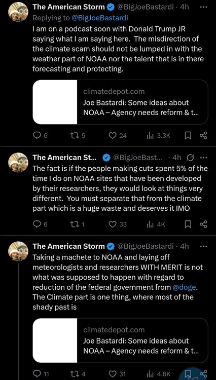
But at least he’s against the massive firings of the non-climate science portion of NOAA. I wasn’t so sure he was going to say that. I thought he was either going to say nothing or defend all of the firings due to political leanings.
-
25 minutes ago, PhiEaglesfan712 said:
Not really. We had a strong el nino in 1982-83, then the double-year event in 1986-88, and again in 1991-92. That's 3 el nino events in a 10-year span. Then another 6-year gap between the 1991-92 event and 1997-98 (a 4th in just over 15 years). 2009-10 and 2015-16 is another 6-year gap.
The common theme with these strong/super el ninos was either a +PDO (like we had for most of the 80s and 90s) or a flip to +PDO (which is what happened in the years leading up to 2015-16). If we can get a flip to +PDO in the next few years, I think a super el nino in 2027-28 can happen.
What about El Niños of 1994-5 and 2014-5?
-
Does anyone who isn’t a WxBell subscriber want to guess what Joe Bastardi just said about the NOAA firings?
-
3 hours ago, Rjay said:
At another site’s forum I posted the above tweet. A knowledgeable pro met there responded to me:
“Something doesn't add up here because Alaska has been expanding AUTOMATED balloon launches across the state that don't require humans.
This sounds like it could be part of that project.
NOAA adopts technology to automate weather balloon launches
Demonstration project underway as Alaska receives first autolaunch stations”
My comment: This link dates way back to 5/7/2018:
https://www.noaa.gov/media-release/noaa-adopts-technology-to-automate-weather-balloon-launches
After nearly two years of field testing the technology in Kodiak, NWS has initiated a demonstration of autolaunchers in Alaska, with two of the state’s 13 upper-air sites already using them. Annette, Alaska, will receive an autolaunch system this month, and the technology will be installed across the state’s remaining 10 sites over the next two years.”


.png.b4fca66742db9ddf15635d06d9540679.png)


2024-2025 La Nina
in Weather Forecasting and Discussion
Posted
Why not just go by RONI? It dipped way down to moderate (-1.09 in NDJ) and that was the 7th straight -0.5- trimonth (starting with the rounded -0.46 of MJJ). Isn’t that enough?