

GaWx
-
Posts
15,984 -
Joined
Content Type
Profiles
Blogs
Forums
American Weather
Media Demo
Store
Gallery
Posts posted by GaWx
-
-
Bismarck, ND, had a record low yesterday of -39F. There’s been only one low as cold or colder than that that later in the season there and that was the very next date: -43 on 2/19/1929. That’s quite impressive considering our warmer globe and especially because record low lows have been especially more difficult.
Minot, ND, set a new record low of -33F, which is the latest that cold in the season. Although records only go back to 1948, that’s obviously still quite impressive!
-
 1
1
-
-
A rainy chilly day (high 40s to 50) here all day. The high will be ~15 BN.
-
 2
2
-
-
28 minutes ago, kayman said:
Finally, far too many on this subforum here while always talking about NC weather that is 9 out 10 times that it's the Triangle or Raleigh like Charlotte is irrelevant. I see why so few of us post because this is annoying.
I’m in SE GA and know of only 3 others from the general area who (semi) actively post. And I’m much further than you from RDU/GSO. So, take your situation and multiply it by 100. That’s my situation. Charlotte may be irrelevant but Savannah/Waycross hardly even exist relatively speaking! But I’m not complaining and have no choice/accept it as the higher interest follows the locations of most posts: RDU/GSO. Fortunately, I enjoy tracking wx/models in the SE regardless of where, what kind of wx, etc. Doesn’t have to be IMBY wintry, which is obviously the most exciting but rare. (I never had a chance with this storm.) Otherwise, I’d hardly be posting. I like to track temps, rain, wind, and other wx too. I enjoy following model trends and evaluating models due to my statistical background.
-
9
-
1
-
-
New Euro Weeklies fwiw have a colder signal for the week Mar 3-9:
Yesterday it had a decent mild signal:

Today the signal has switched to a neutral to weak cold signal:

H5 changes for same week:
Yesterday:

Today:

-
5
-
-
4 minutes ago, ORH_wxman said:
1995 had a biggie on the last day of February. Close enough. Massive ice storm hit NY state in March 1991.
Would you mind pinning a thread for us in the SE forum? It is the 2/19-20 obs thread. Our moderators haven’t been available for awhile. TIA
-
 1
1
-
-
-
1
-
 2
2
-
-
13 hours ago, dsaur said:
Can you tell me where to get in line for the big winter storm in the first two weeks of March ?? I feel the calling.... It'll be 32 years since the blizzard. Three and two are 5. There are three bugs pictured above. 5 less three is two...and there have been two snows here this year! Boom!!! Drop the mike.
Well Tony and other SE snowlovers, there’s this pure entertainment value from the 12Z GFS for late March 2-3:

Of course, daytime Barney is there:

-
2
-
1
-
 1
1
-
-
This is Atlanta’s forecast: What’s with the “very light” drizzle? Isn’t drizzle all very light by definition?
REST OF TODAY
CLOUDY. SHOWERS EARLY THIS MORNING, THEN A
SLIGHT CHANCE OF SHOWERS AND VERY LIGHT DRIZZLE THIS AFTERNOON.
HIGHS IN THE UPPER 40S. NORTHEAST WINDS 5 TO 10 MPH. CHANCE OF
RAIN 80 PERCENT.
TONIGHT
MOSTLY CLOUDY WITH A SLIGHT CHANCE OF VERY LIGHT
DRIZZLE IN THE EVENING-
1
-
3
-
-
37 minutes ago, NorthHillsWx said:
WINTER STORM WARNING BRICK
Here’s the main change for Wake county, which is for tonight and which lead to the WSW:
TONIGHT
CLOUDY. SNOW, SLEET WITH A SLIGHT CHANCE OF FREEZING
RAIN IN THE EVENING, THEN A CHANCE OF SNOW AFTER MIDNIGHT.
ADDITIONAL SNOW AND SLEET ACCUMULATION UP TO 1 INCH.Prior to this, they had “little or no” additional accumulation tonight.
-
1
-
-
6 minutes ago, ForsythWx said:
Both 12k and 3k NAM trended better for triad and WNC. Dry slot has been filled somewhat
3K 6Z NAM 850 0C line is much further north than the 0Z. Now it has significant sleet in RDU!
-
3 hours ago, dsaur said:
Can you tell me where to get in line for the big winter storm in the first two weeks of March ?? I feel the calling.... It'll be 32 years since the blizzard. Three and two are 5. There are three bugs pictured above. 5 less three is two...and there have been two snows here this year! Boom!!! Drop the mike.
Sounds good to me, Tony!
And as Tony has often reminded us, don’t write off winter til after the Masters (mid April)!
In the meantime, a full 5 weeks before the Masters, the 0Z EPS continues to show influence from a famous purple dinosaur (not dsaur lol): check out the cross polar flow! Coldest anomalies for any land region in the N Hem…sound familiar?

-
3
-
-
0Z Euro Kuchera: up slightly at RDU to 2.6” from 2.4”/2.3” prior two runs:

RDU qpf 0.29” (nearly) all falling as snow; slightly higher than prior 4 runs (they were 0.25-0.26”):

-
1
-
-
For the record to help evaluate model performance, 0Z UKMET for RDU dropped to 0.9” snow on 10:1 of qpf. 100% snow.
Last runs starting with 0Z 2/17 run:
1.9”, 0.6”, 2.1”, 1.5”, 1.4”, 2.2”, 0.9”. So, UK has been drier than most models since the 0Z 2/17 run.
Before that, UK was among the snowier models with 5.5” on 12Z 2/16 run. These are Pivotal 10:1 snow amounts. In these cases they were usable because the precip has been almost all snow since the 12Z 2/16 run.
-
25 minutes ago, StantonParkHoya said:
GaWx, do I have to tell you what a non-anomalously low height spells in the SE on March 5th?
No, I know:


-
2
-
3
-
-
5 hours ago, Met1985 said:
The mjo looks to possibly loop in phase 8 which would carry us into March. Yeah of course the usual caveats apply but I don't think we are nearly done with the cold after this week. Ryan Maue has been really harping on another visit from the pv the past few weeks going into March. He actually made a post yesterday.
Very much fwiw, I think Barney hacked the 360 hour 12Z EPS and GEFS:


-
1
-
-
30 minutes ago, NorthHillsWx said:
Yes. A thunderstorm complex that may or may not exist can completely alter what a CAM sees
If the thunderstorms do exist, wouId high resolution be more accurate?
-
3km vs 12km 18Z WB NAM Kuchera: RDU 4.0” on both
3 km:

12 km:
-
1
-
-
6 minutes ago, Brick Tamland said:
NAM is finally colder.

The 18Z 12km NAM has the low further offshore than the 12Z.
-
4 minutes ago, CaryWx said:
Eric dropped this one in another place...
Thanks. However, this map is from the GEFS rather than the GFS. You mentioned the GFS and it is colder.
You had said: “12z gfs looks like nam-12km as well with 850s up in northern wake”
-
27 minutes ago, CaryWx said:
12z gfs looks like nam-12km as well with 850s up in northern wake
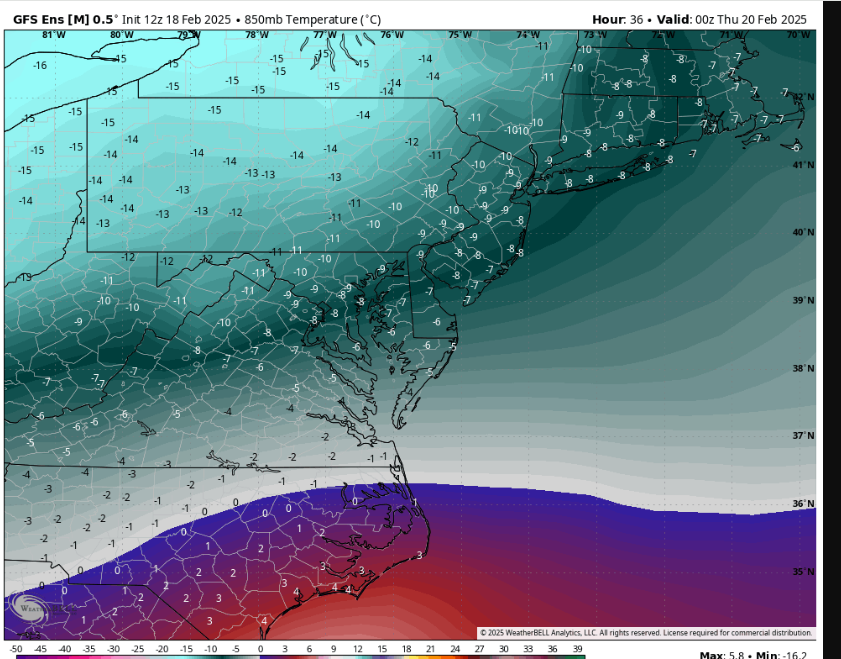
Do you have a 12Z GFS 850 mb map showing this? I’d like to see it. At 3 hour intervals (based on cross checking Pivotal), this TT GFS 850 map (hour 30) is the warmest at Wake and 0C is almost as far S as the S Wake border leaving RDU at -1C:

-
Today’s preliminary CPC PNA of +1.39 is the highest daily CPC PNA of this winter. And it will be rising further with a target near +1.75 ~Feb 21st. That would be the highest CPC PNA on any winter day since 12/7/2020!

Per GEFS, I’m currently projecting a Feb CPC PNA of ~+1.60. That along with the +1.70 of Dec and +1.05 of Jan would give a DJF averaged CPC PNA of +1.45. The current highest DJF averaged CPC PNA (back to 1950-1) are the +1.43 of 2015-6 and the +1.41 of 1976-7, both El Niños. So, 2024-5 still has a shot at having the strongest DJF averaged CPC PNA on record (back to 1950-1). It will obliterate the current highest La Niña CPC PNA of +0.89 (2000-01).
Note that I was careful to always call this the “CPC PNA” as opposed to just “PNA” due to Chuck and others questioning the CPC calculations of the CPC PNA in parts of late Jan and early Feb.
-
2
-
-
21 minutes ago, CaryWx said:
The NAM looks like lots of mixing but maybe I'm not looking at the latest one.
Check out how much colder is the 3 km vs 12 km 12Z NAM at RDU:
3 km: <0C at 850 at 4PM, similar to globals

12 km: >0C at 850 at 4PM, warmer than globals; it has a 2 mb stronger surface low and the low is quite a bit N of 3km position

-
1
-
-
23 minutes ago, CaryWx said:
The NAM looks like lots of mixing but maybe I'm not looking at the latest one.
Yes, the 12km 12Z NAM does have a good bit of sleet along with 850s getting above 0C. But the 3km is several degrees colder at 850/never getting above 0C. The globals are similar to the 12km NAM in that respect. I think some sleet is possible but no ZR and mainly snow is what I expect as of now in RDU.
-
1
-
-
5 minutes ago, NorthHillsWx said:
The mix line is going to absolutely break hearts tomorrow especially if areas just north of it get enough moisture for a big snow. I could be tempted to up the triangle forecast to 2-4” (or even 3-5”) after seeing 12z guidance roll in if I was RAH but they have that mix in their back pocket to keep most of the area in the 1-3” range. If trends continue though I could see Wake upgraded simply bc all of those solutions, even the sleet, are highly impactful if the higher QPF is realized. And northern wake would probably hit warning criteria unless the 12z warm nose isn’t on crack. I don’t think they have to blink until tomorrow morning though unless afternoon models keep increasing. It’s funny, the more QPF we get the trickier the forecast becomes bc the difference of totals in the mix vs non mix areas for from like Tr-1/2” to 3” on one side or the other to 1/2-1” to 6-8”. The upper margin increases disproportionately
I still don’t see much if any mixing of non-snow precip in the RDU area. This looks like a classic practically all snow Miller A there imo (maybe just a little sleet). 850s look to stay safely <0C from what I’ve been seeing. You may even get a little higher than 10:1 ratios of snow.
-
1
-


February 19-20 Major Winter Storm Threat
in Southeastern States
Posted
RDU averages:
1971-2000: 6.9”
1981-2010: 5.9”
1991-2020: 5.1”
From https://www.weather.gov/wrh/Climate?wfo=rah
Charlotte averages:
1971-2000: 5.2”
1981-2010: 4.2”
1991-2020: 3.5”
From https://www.weather.gov/wrh/Climate?wfo=gsp
So, you’re right that RDU hasn't averaged twice as much as Charlotte. It has been more like 1.33 to 1.45 as much. But RDU averaged a bit more than you said.