

GaWx
-
Posts
11,514 -
Joined
Content Type
Profiles
Blogs
Forums
American Weather
Media Demo
Store
Gallery
Posts posted by GaWx
-
-
The potential for significant SE wintry precip 2/15-20, especially 2/17-20, is not at all going away and is if anything increasing as we get closer while the big picture doesn’t change. At least 75% of the last 3 GEFS runs ending with the 6Z have SE US wintry precip outside of the mountains somewhere within Feb 15-20. About 50% of the 6Z members have it including outside of NC with 4 of the 30 even as far south as N FL.
It is hard to look better than this 10-15 days out. The big picture is still very much intact with a hard to beat combo of a very strong -AO, moderate +PNA, -EPO, neutral to -NAO, strong subtropical jet/split flow, and the tendency for 50/50 lows (which tend to hold cold in longer). Moderate+ El Niño climo is quite supportive, too. It never hurts to have analogs on your side.
I hope to post more about the very strong -AO later as far as El Niño analogs are concerned.
-
 3
3
-
-
4 hours ago, mitchnick said:
Surprising how the Gefs and Geps saw the warming first at 10mb as per my post of 1/24 @ you. Eps was uncharacteristically late to the party.
Also, GEFS has been better than GEPS. Interestingly though, 0Z GEFS today (2/4) has backed off slightly on an actual reversal with a lowest mean just above zero vs -2 on the 0Z 2/3 run. Also, it’s mean though still low edges back up to +9 later vs staying under +7 yesterday.
-
On 2/2/2024 at 3:12 PM, GaWx said:
Groundhog weeklies say spring may be awhile: mean dips to +11. A week ago the 1/26 run had only 3 midmonth reversals with the mean dipping only to +31!
Today’s extended EPS mean drops to a mere +4 (vs +11 two days ago and +31 nine days ago) with numerous members having a major SSW. Also, like is the case on the extended GEFS, the SPV is now much weaker than normal from mid Feb into March. The chance for a cold E US March continues to increase!

-
 1
1
-
-
Rainy, windy, and cool here late this afternoon. A good day to stay inside!
Update: After ~7 hours of rain that included periods of heavy rain along with rumbles of thunder that I’m still hearing (there even was one cloud to ground strike a few hours ago), it is finally ending for now. I’ll get totals tomorrow.
We got another period of rain on Monday but not heavy. I very roughly estimate my Sun-Mon (2/4-5) total to have been 1.75”.
-
12Z EPS:
-Unlike the GEFS/GEPS and although there are some wet members, there are many dry members and thus the mean is dry/BN in the SE. But keep in mind that it ends 24 hours earlier though it is drier through 2/19 for sure.
-Although there are a good number of very cold members, they are balanced by a good number of mild members late in the period. Thus, the mean is warmer than both of the GEFS and GEPS late in the period with the cold temps warming to mainly near normal temperatures by the end of the period.
-Unlike the GEFS/GEPS means of above average snowfall in NC, the EPS has BN/little snow.
So to summarize my posts regarding the 12Z ensembles for SE wintry precip potential Feb 15-19/20, the GEFS and GEPS means have AN snowfall and cold whereas the EPS mean is drier with BN snow and less cold temps late. Going to be lots of fun to see how this plays out.
-
3
-
 1
1
-
 1
1
-
-
33 minutes ago, wncsnow said:
Other ENS are dry including the Canadian

-The Canadian ens map you’re showing has near normal precip (white area) for that 5 day period. Near normal is neither wet nor dry in NC in mid Feb.
-1/2 of the members have snow in NC outside of the mtns
-4 of the 20 (20%) have widespread 3”+ snowfall, all including heaviest of 6”+, in NC.
-A good number of the wet members in NC have no wintry outside of the mountains.
-2 of the 20 (10%) have wintry as far south as N FL.
I haven’t yet had a chance to look at the EPS.-
2
-
-
44 minutes ago, wncsnow said:
It's dry
Nope, especially 2/17-20.
From 12Z GEFS outside of the mountains 2/15-20:
-21 of 30 members have wintry precip in NC.
-13 have it in GA including 8 central and/or south
-11 have it in SC including 7 in south
-3 have it in N FL
-6 have ZR and/or IP included, including part or all of the 2 of the 3 in N FL
-
4
-
-
12Z GEFS big picture in more ways than one: classic split flow has been showing for this period for weeks. This is about as good a look as I’ve seen in recent years this far out. Ingredients are there. But will they mix right? That’s always the tough part for the SE, especially.

-
5
-
 2
2
-
-
12Z GEFS for Feb 16 is by a good margin coldest in at least the last 16 runs. Now let's see how well the ST jet/moisture interacts.
-
3
-
-
GLAAM prediction from CFS ensemble is saying we’re probably headed to solid +/Nino pattern 2/15+.

-
The potential isn’t going away folks. Rather, it is persisting and as we get closer it is increasing. The potential on the 6Z GEFS for widespread significant wintry precip during a portion of Feb 15-20 in NC and more specifically from a classic Miller A GOM originating low throughout a large portion of the SE during a portion of Feb 17-20 is about as high as I can remember on any GEFS in recent years when looking out 11-16 days. When I consider not only the actual panels of the run but also similar model runs of the last few days along with the progged solid +PNA/-EPO/-AO, neutral to -NAO, a persistent 50/50 low, a strong El Niño related subtropical jet/split flow, and moderate+ Nino mid to late Feb climo, it is hard to hold in my enthusiasm for what MAY occur. And it is always a matter of what MAY and never nowhere near what WILL when looking out 11-16 days. The MAY is why we have these forecast discussion threads as opposed to nonexistent crystal ball threads.
Classic split flow:

Many members with Miller A GOM/off SE coast lows:

-
4
-
-
If the extended 2/3 10 mb forecast along with the most recent CFS 12 run ensemble 2m temperature means in addition to recent Euro Weeklies are any indication of what’s to come, we may very well be getting a cold first half of March at a bare minimum! The mean 10 mb wind never recovers over +7 after not getting below +30 in mid to late Feb on the Jan 25 run!! That 1/25 run had a mere 3% chance for a Feb reversal and now it is 75%+!
I’ll delete this image very soon as it is way too large to keep here considering the attachment limits:

-
3
-
3
-
-
About 30% of the 18Z GEFS members have wintry precip in the SE outside of the mountains during 2/17-19.
-
1
-
-
1 hour ago, GaWx said:
EPS: ~25% of members have strong cold within 2/17-18 but snow is very limited (though it ends a day earlier than GEFS).
Meanwhile, though the 12Z EPS has virtually no snow, the 0Z control has moderate snow 2/18 and 3/2-3.
-
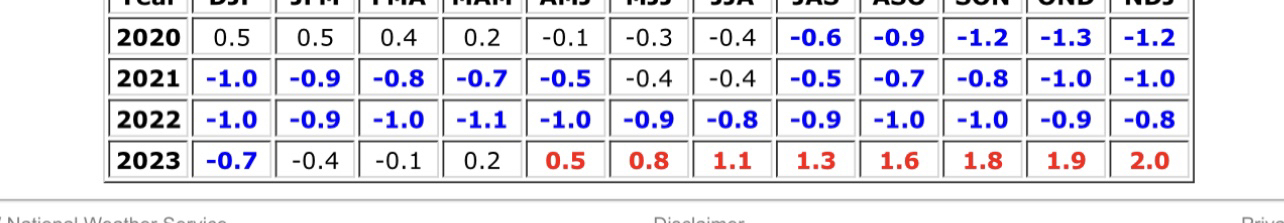
On 9/2/2023 at 6:35 PM, griteater said:
My prediction:
Oct: 1.8
Nov: 2.0
Dec: 2.0
Jan: 1.9
Max Tri-Monthly ONI: 1.97 rounded to 2.0 for NDJ
I voted for "Super (>2.0)", but that's with considering Super as "2.0 and higher" instead of "higher than 2.0" (I know, I'm not playing by the rules). In addition, I consider an official SST Super Nino not just one tri-monthly reaching 2.0, but 3 tri-monthlies reaching 2.0 <OR> the average of the 3 highest tri-monthlies being 2.0 or greater...got this from the way Jan Null designates ENSO strength, which I like:
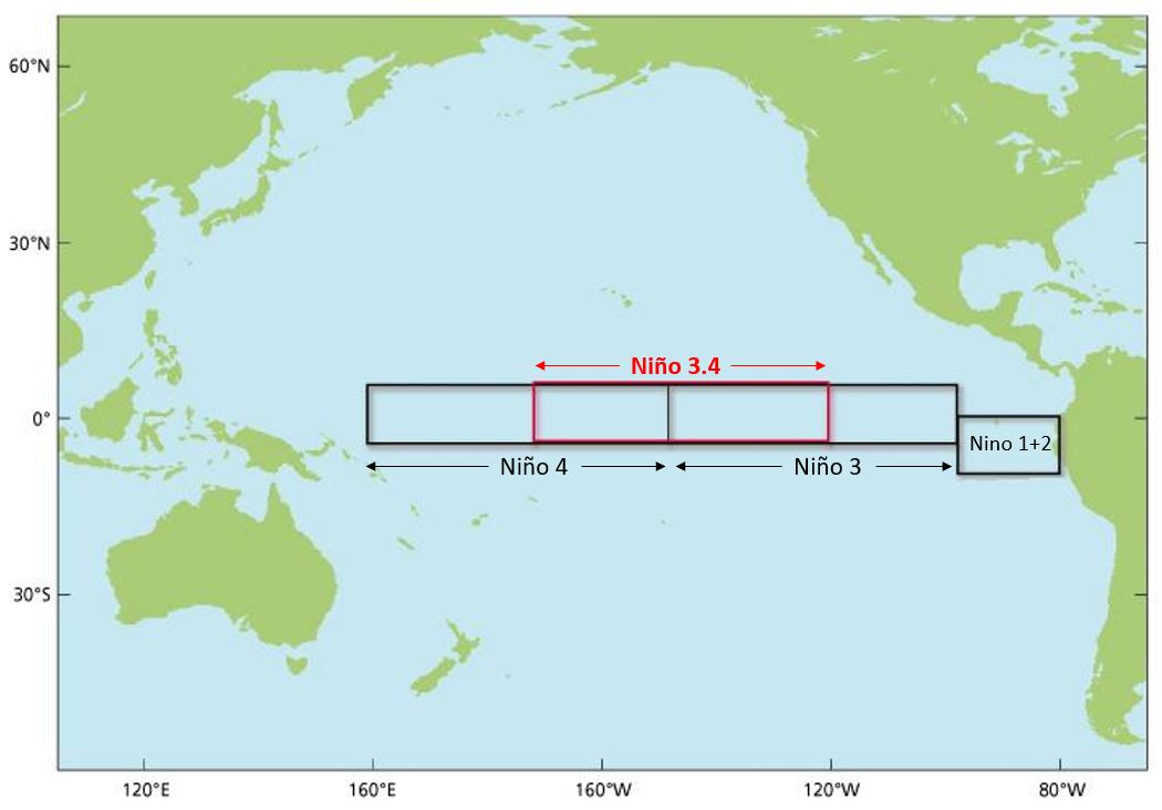
Source: El Niño and La Niña Years and Intensities (ggweather.com)
"The Oceanic Niño Index (ONI) has become the de-facto standard that NOAA uses for classifying El Niño (warm) and La Niña (cool) events in the eastern tropical Pacific. It is the running 3-month mean SST anomaly for the Niño 3.4 region (i.e., 5oN-5oS, 120o-170oW). Events are defined as 5 consecutive overlapping 3-month periods at or above the +0.5o anomaly for warm (El Niño) events and at or below the -0.5 anomaly for cool (La Niña) events. The threshold is further broken down into Weak (with a 0.5 to 0.9 SST anomaly), Moderate (1.0 to 1.4), Strong (1.5 to 1.9) and Very Strong (≥ 2.0) events. For the purpose of this report for an event to be categorized as weak, moderate, strong or very strong it must have equaled or exceeded the threshold of the highest category for at least 3 consecutive overlapping 3-month periods."
This is about as good as it gets per his monthlies and getting the unrounded peak exactly and thus I think should be the winner! However, he messed up his perfection by “not playing by the rules” (as he stated) since his definition of super is 2.0+, not >2.0 (with which I agree). Thus he voted >2.0 even though he predicted +1.97 unrounded/+2.0 rounded. I still say he wins. Congrats!
-
3
-
-
7 minutes ago, BuffaloWeather said:
Still super 2.0 rounded, everyone here told him no chance and he stuck with his guns.
That he did. So, congrats @snowman19for that!
This one is just like 1965-6, which peaked at +1.98. That one is often left out of the “super” peaking group even though it also rounded to 2.0. Not that it matters wx wise.Edit: for wx though, RONI may matter more.
-
5
-
-
11 minutes ago, BuffaloWeather said:
Congrats @snowman19

The unrounded ONI max came in at +1.97. RONI never made strong with another +1.49.
-
3
-
-
EPS: ~25% of members have strong cold within 2/17-18 but snow is very limited (though it ends a day earlier than GEFS).
-
12Z GEFS: pretty wet SE 2/18-9 with 9 of 31 members having wintry precip. Many members have a GOM low.
-
12Z GEFS is warmer 2/15 than any recent run.
-
2
-
2
-
-
The 2/3 models (image below) are even more bullish for a major SSW with the GFS’ 2/16 reversal plunging way down to -17 and still dropping at the end (likely overdone)! GEFS mean now drops to -2 and still dropping at the end. Including the GFS, 6 members drop below -10 with a couple more possible after the end.
GEFS extended means for mid to late Feb
-1/25 run: stayed over +30
-1/29 run: stayed over +20
-1/30 run: stayed over +15
-1/31 & 2/1 runs: stayed over +10
-2/2 run: stayed over +7
-2/3 run: dipped to -2 and still dropping into extended, which hasn’t been released yet

Meanwhile, CFS forecasts for the 1st half of Mar in the E US have gotten much colder.
-
2
-
-
11 hours ago, NorthHillsWx said:
We’re reaching the part of our climo where we need anomalous cold for frozen and that isn’t showing up
-The mean calendar day snowfall is highest for 1/19, 1/25, 2/9, 2/26, and 3/2 with 3/2 the peak.
-The highest mean 7 day periods are 1/24-30 and 2/26-3/3 with 2/26-3/3 THE peak.
-There’s no telling how cold the SE will get. It is still too far out to have high confidence in and ensemble means are not going to show the degree of cold well due to timing differences of members causing a smoothing of the mean. But some of the projections I’ve seen are quite cold for that far out on a mean of an ensemble. Plus the cold is being forecasted to be strongest anomalywise in the E US rather than the mid Jan central US.
-The Euro Weeklies severely underestimated the degree of mid Jan cold with them actually having warm anomalies throughout the US just over 2 weeks out! Even the map issued on 1/15 for 1/15-1/21 was quite a bit underdone.
-Moderate+ El Nino climo favors 2/15+ for the best period for snowfall, even moreso for the 9 that had none in Dec and Jan. Those 9 averaged over 5” just for 2/15+.
-
2
-
1
-
-
2 hours ago, frd said:
No quick recovery for the PV after the rapid weakening in two weeks. The u-mean 10 hPa 60N does not return to the ERA5 mean until later in March.
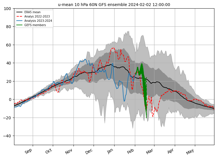
Thanks for posting this. The dashed red line that doesn’t come back up to the ERA5 mean until late March is from 2023 and isn’t the GEFS forecast. GEFS is all in green and ends on Feb 18. One member plunges to -20. It appears that ~30% go <0 by Feb 18, a significant increase vs recent runs. Trends have clearly been going toward a major SSW over the last few days. The earliest reverse is Feb 15. The mean likely gets down to ~+4.
-
2
-
-
On 2/2/2024 at 1:58 PM, Stormchaserchuck1 said:
+15-20 days.. ~March 2-7
Groundhog weeklies say spring may be awhile: mean dips to +11 with ~15 reversals at midmonth. A week ago the 1/26 run had only 3 midmonth reversals with the mean dipping only to +31!-
3
-


Mid to Long Range Discussion ~ 2024
in Southeastern States
Posted
All models are predicting the AO to drop to -3 or lower at mid month with the likelihood of some days dipping to near -4 being implied. The chance of a sub -2 AO averaged out during 2/15-29 is increasing and is close to becoming likely. (There’s a good chance for a +0.3+ PNA averaged out during the same period.)
Here are the strongest -AOs averaged out during 2/15-28(9) for El Niño:
2010: -4.1 (PNA +0.2)
1969: -3.4 (PNA -0.1)
1958: -2.5 (PNA +0.9)
2005: -2.4 (PNA +0.4)
1952: -2.0 (PNA +0.4)
1977: -1.8 (PNA +1.0)
1987: -1.7 (PNA +0.3)
1970: -1.6 (PNA +0.7)
AO lowest daily 2/15-28(9) -3 or lower during El Nino:
1952, 58, 64, 66, 69, 78, 2005, 10
AO lowest daily 2/15-28(9) -4 or lower during El Nino:
1958, 69, 2005, 10