

GaWx
-
Posts
11,514 -
Joined
Content Type
Profiles
Blogs
Forums
American Weather
Media Demo
Store
Gallery
Posts posted by GaWx
-
-
The 12Z UK is significantly warmer than the 0Z that I showed last night. So, the overall warmer trend of models vs yesterday continues. The flow is overall now being dominated by the moist subtropical/Pacific flow instead of a true split flow of a nice mix of N cold and ST moist. Suppressed low tracks well into GOM are gone for now.
-
 1
1
-
 1
1
-
-
Look how different H5/sfc is prestorm on the 12Z GEFS vs just 24 hours ago:
24 hours ago- split flow with sfc Canadian high pressing into upper SE from N stream ahead of storm while suppressed low forms well down in W Gulf on ST stream; note H5 hts flow (follow lt blue, for example) from Dakotas ESE to Mid Atlantic states, a perfect pattern to provide just enough cold to the SE without an overpowering plunge of cold, dry:

Latest: N stream instead gives up with Canadian high no longer pushing cold air into SE; H5 hts flow, including lt blue, from Dakotas E to NEng instead of ESE to MidAtlantic; W GOM low much further N/no longer suppressed

-
2
-
-
The 2/13-20 0Z 2/10 GEFS predicted AO rose quite a bit again to -2.2 (see image below) vs -2.7 on 2/9, -3.2 on 2/8, -3.0 on 2/7, and -3.5 on 2/6. Also, the NAO is higher. So, not good trends for 2nd day in a row at 0Z on the GEFS:
Today’s AO: 2/13-20 at -2.2

Compare to just 2 days ago: 2/13-20 at -3.2

-
1
-
1
-
 1
1
-
-
Did someone say 0Z UKMET?


-
12Z EPS has a good number of suppressed low tracks, not too unlike prior runs. Suppressed would obviously give a good portion of the SE more opportunities.
-
5
-
-
Major snowfall 2/18 E NC to the coast on 12Z Euro!
Edit: There’s also followup light precip breaking out deep S on 2/19 within a strong wedge associated with a second weak GOM low.
-
5
-
-
The 12Z GEFS mean was the coldest run for 2/17-18 in much of the SE in many runs due largely to an increase in the number of suppressed low tracks. As a result, much of the SE has increased qpf and mean wintry precip vs the 6Z (especially ATL-GSO south), and there’s a notable increase in the deep south. N FL is back up to two with wintry.
So, at 12Z, the GFS, GEFS, and the not yet mentioned CMC have a similar setup on 2/18 with a suppressed Miller A/slider Gulf low. Also, the 12Z GEPS had a similar change.
-
2
-
-
23 minutes ago, buckeyefan1 said:
I was living on Lady’s Island and it was a beautiful 5” snow that lasted for a while

You picked the perfect time to live on the coast as Jan of 2018 was the biggest SE coastal winter storm since Dec of 1989 for many!
Here, there was ~0.5” of ZR (probably the most in one storm in nearly 100 years…it stopped just before widespread outages were about to start) and 2” of a combo of sleet and snow. A good portion of that 2” hung on in shady areas for 4 days, a very rare feat! There being sleet in it combined with it being several degrees below freezing during most of the storm and very cold to follow allowed it to stick around for so long.-
2
-
-
53 minutes ago, Blizzard22 said:
6 years seems like a long time without snow. Is that normal for your area ?
Going 6 years without even a T of wintry in this area is the longest since at the very least the 1940s and possibly even since the 1870s-80s! There’s missing snow data between the traces of Dec of 1944 and Nov of 1950. So, there’s a slight chance there was none then although that would still be just under 6 years. So, the current drought of 6 years, 1 month is for sure the longest since at the very least the 1880s.
-
3
-
1
-
-
12 minutes ago, jpbart said:
Living smack dab in the middle of SC. I am curious about how the gap between potential snow fall locations. This kind of snow event is especially frustrating to those of us in the middle of the gap. Anybody care to enlighten us forever snowless folks?
This is just digital out 9 days on an operational GFS. Here today gone tomorrow happens very often in these unusual locations. Haven’t seen the real thing in 6 years. Not that digital isn’t fun to see.
-
3
-
-
Wintry precip way down in my area on 2/18 on 12Z GFS! These sharp changes from run to run show the level of uncertainty.
Not all of this is snow as some is other wintry:

-
4
-
1
-
 1
1
-
-
Absolutely the 12Z GFS is clearly much better.
-
2
-
-
The 2/13-20 averaged 0Z 2/9 GEFS predicted AO rose quite a bit to -2.7 (see image below) vs -3.2 on 2/8, -3.0 on 2/7, and -3.5 on 2/6. Also, the PNA is lower while the NAO is higher. So, not good trends at 0Z on the GEFS vs yesterday. Hopefully that trend will reverse as there’s still time.
Strongest -AO El Niño averaged 2/13-20 (lowest daily) out of 25 Ninos since 1952:
1969: -4.8 (-5.1) (PNA: -0.1)
2010: -4.4 (-5.1) (PNA: +0.7)
1978: -2.6 (-4.8) (PNA: +0.8)
1958: -2.5 (-4.0) (PNA: +1.1)
1970: -2.4 (-4.0)
1964: -2.4 (-3.4)
1987: -2.4 (-3.3)
1966: -2.2 (-3.5)
1952: -2.1 (-2.5)
1983: -2.0 (-2.7)
1977: -1.2 (-2.1)
2007: -1.2 (-1.9)
2005: -1.1 (-1.7)

-
1
-
1
-
-
Let’s see how 12Z runs go. Not starting off well with the ICON, which has more Pacific flow than recent runs through 144.
-
2
-
-
The 6Z GEFS was less suppressed with the mean low track and was warmer overall with much less snow throughout the SE and very few (only 3/10%) with wintry into the deep SE. Only one member has wintry in N FL 2/17-21 and that one only barely. That compares with one run that had 10/33% with N FL wintry and a good number with 3-5.
-
2
-
-
1 hour ago, NorthHillsWx said:
Looking at hour 240 dewpoints and 850s along with the control, it appears that had the Euro gone further that this would likely have resulted in a significant winter storm from a mix for especially NE GA into the W half of NC.
-
1
-
-
Once again the GEFS mean and GFS are on different planets. The 0Z GEFS is pretty impressive from NE GA through much of NC.
-
If only the CMC at 222 were remotely credible.

-
I wish the JMA were a credible model at 192.
Edit: 0Z ICON at 162 looks nice.
-
45 minutes ago, Blizzard22 said:
I have never in my life seen ice in Georgia after Valentine's Day.
Even though you’ve never seen it, it has occurred a number of times in GA even in Mar including 3/2-3/1962 in a good portion of inland SOUTH GA (major storm), light icing to the coast on 3/2/1980 (El Nino) and a major one as late as 3/25/1971 in the Atlanta-Athens areas! There was also major icing even to the coast as late as 2/25/1914 (one of their worst ever)(another El Niño)! So, I wouldn’t at all discount the possibility of ice in GA with this next potential threat.
-
2
-
-
34 minutes ago, wncsnow said:
How do the other weeks look?
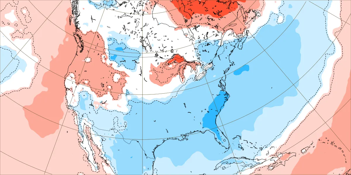
All have BN temps, but none are this cold.
-
3
-
-
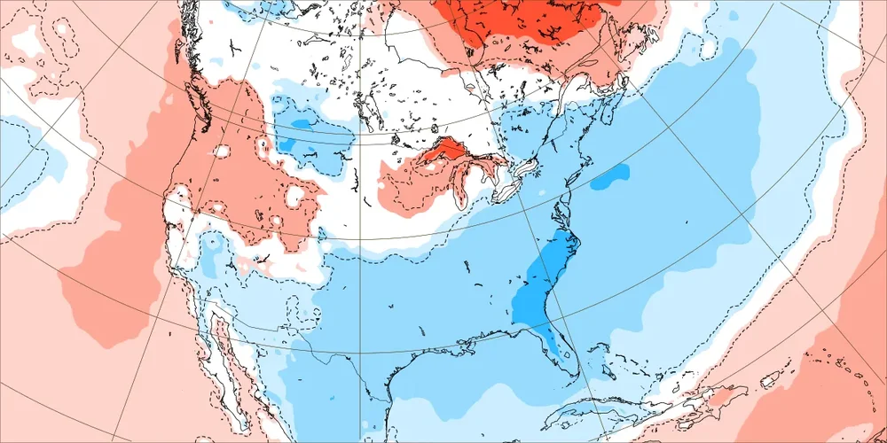
This is the coldest the Euro Weeklies have been in the SE for the week of 2/19-26: dark blue is ~6-7 F BN. That’s pretty significant for an ensemble mean and it could even trend colder. But even if not, a week of 6-7 BN implies the coldest day would probably easily be in the teens or so BN.
-
4
-
-
1 minute ago, buckeyefan1 said:
Well, look at that. There’s finally an ops run showing some wintertime fun

Just for the record, the 12Z GFS isn’t the first GFS showing significant wintry somewhere in the SE as most runs over the last few days have shown that. Not always in your BY but somewhere in the SE, sometimes deep south.
-
2
-
2
-
3
-
-
1 minute ago, CaryWx said:
Unless trolling. It's going to be in phase 8 albeit low low p8
Low p8 is about as good a place as any.
-
1
-


Mid to Long Range Discussion ~ 2024
in Southeastern States
Posted
12z EPS continues with the trend of less and less sfc high pressure to the north out ahead of any Gulf low to allow already established cold air to meet up with overrunning moisture (split flow). The number of ENE moving suppressed/S slider GOM members meeting up with the cold continues to drop and instead there are more lows that are scooting out earlier on a more NE trajectory along the cold front as the cold comes in from the NW (cold chasing moisture). As a result, there’s little snow outside of NC. NC still has some big dogs (6 out of 50) and 3 moderate dogs, but ATL (and much of GA/SC) has but one big dog (4”) and then one 2” and one 1” out of 50.
So, today’s trend has not been kind at all to winter lovers overall. However, we still have another 1-2 days or so for the last chance to turn things back around.