Buddy1987
-
Posts
4,511 -
Joined
-
Last visited
Content Type
Profiles
Blogs
Forums
American Weather
Media Demo
Store
Gallery
Everything posted by Buddy1987
-
I think it’s premature to say NC in general. CLT and RDU I would agree but north of 40 I don’t believe so. That TPV is still flying all over the place on the models.That being said I’m not sure as to how many people in the forum actually live along or north of 40. I feel like I’m out on an island sometimes haha
-
January Storm Term Threat Discussions (Day 3 - Day 7)
Buddy1987 replied to WxUSAF's topic in Mid Atlantic
Can I just get clarification from you or @CAPE as to what happens if the models are mistiming this TPV and it comes even further south and east. Does that mean confluence starts to strengthen and force the storm more south of its current projection? -
January Storm Term Threat Discussions (Day 3 - Day 7)
Buddy1987 replied to WxUSAF's topic in Mid Atlantic
I would say Para would be a great happy medium for everyone in the forum IMO specifically with distribution of snow totals if taken at face value. Manages between 00z and 06z to have strengthened the storm by a couple mb albeit It is hauling ass. Has it at 988 east of RIC. -
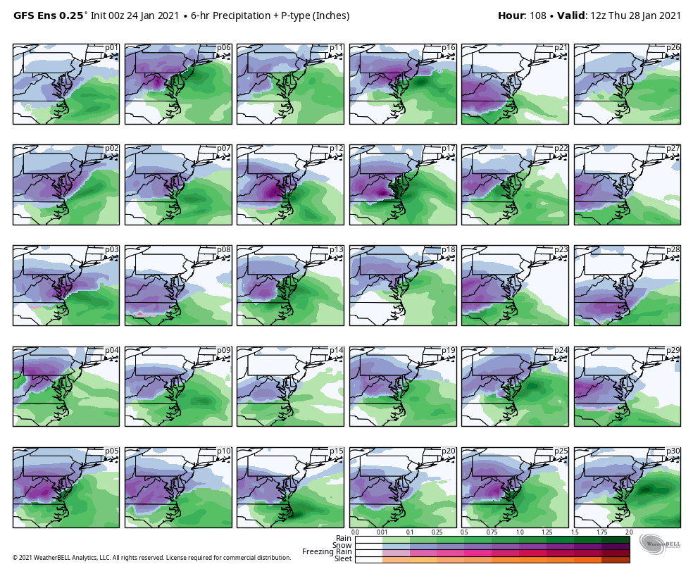
And just for reference the more I dissect the 0z GEFS was GREAT IMO if you wanted a trend somewhat (P10, P23, P28 YES PLEASE!). There are many major hits in there for northern NC in this. There’s still time for this to trend the right way
-
It is absolutely amazing to me the Euro can spit out something like that when basically almost every other model is gung ho I mean even ukmet is more aggressive. I know I’ve seen and read thus far the euro is slower in ejecting the s/w out of the southwest and I think that’s a known flaw and bias in its model suite to where it’s now impacting its evolution.
-
Just got home from having a couple beers. Gfs is just a beat down on that backside ccb. If anything you have to love the continuity amongst consecutive runs. Gfs looks promising I dare say. @Blue_Ridge_Escarpment looks good out your way as well. I overall have a good feeling about this for at least 40 north. I would assume Frosty and folks would be happy even if they got about 1-2” out of this.
-
Looks like good trend on Euro toward the GFS. We really need a little spacing like I alluded to last night so the next storm has some room to breathe and be able to amplify rather than get pinched off. That happens should allow for a stronger system.
-
Ukmet finally put the booze down and has a storm albeit still pretty Far East. Good trend tho IMO to see what the euro ultimately offers.baby steps are key for today
-
More importantly the GEFS agrees with the gfs but in all actuality looks better IMO pretty impressive to see the mean of 4” up this way but even 40 corridor average of about 1.5”

-
January Storm Term Threat Discussions (Day 3 - Day 7)
Buddy1987 replied to WxUSAF's topic in Mid Atlantic
If I can lock in a 3-5” event right now you’d never hear a complaint or a peep out of me just sayin -
Idk where to even access it anymore. Everything I have is stuck at 12z on 1/21
-
It won’t it’ll end up being a paste bomb if you take the gfs at literal face value
-
Honestly I don’t either. Normally if high is positioned correctly then I’d feel a lot better but in a sense there’s really nothing for the primary to push further north and east because the high is too far west to my liking and also allows WAA to flood over (tpv would really be the main saving grace and even that has been modeled to be all over the place). Really comes down to and this is if the ull can undercut us how dynamic it is and how quickly CAA can get going once winds switch in our favor and pump in that cold 1042HP
-
January Storm Term Threat Discussions (Day 3 - Day 7)
Buddy1987 replied to WxUSAF's topic in Mid Atlantic
@clskinsfan 81 demolishing at least for what we’ve grown accustomed to. This thing will change more than I change my underwear so fun to at least see the potential -
@BornAgain13 12z gfs looks more like para and doesn’t drive the low all the way up into WV but rather undercuts and delivers some very nice snows even down toward your way and more so up disc’s wxdude’s and my way. Edit: man really examining the backend of things as it gets cranking that ccb is gonna demolish someone. Verbatim I’d prolly flip to sheets of paper and 32.
-
January Storm Term Threat Discussions (Day 3 - Day 7)
Buddy1987 replied to WxUSAF's topic in Mid Atlantic
At least it’s not pile driving it up into WV and undercutting even me to my south. That is something we should all want to see however other players naturally have to cooperate on the battlefield. -
January Storm Term Threat Discussions (Day 3 - Day 7)
Buddy1987 replied to WxUSAF's topic in Mid Atlantic
Nam looks “diggy” toward the end of its run when comparing to gfs at 90. I’m tempering my expectations as I’m sure most are. Right now threat slightly better for areas to my north and east but I’m far from out of it with para and Canadian looking better region wide. -
Lmao! You’re talking about Kevin. He is such a clown but very funny to keep up with and read. I was in NW CT so about 90 or so min from you via Mass pike. Good to know!
-
January Storm Term Threat Discussions (Day 3 - Day 7)
Buddy1987 replied to WxUSAF's topic in Mid Atlantic
Would you consider that to be a bias of the euro with s/w ejection with systems coming out of the southwest like we’ve seen in past storms? -
When it’s euro against the world here I don’t buy it. Do I fully entrust in the gfs? Never. When it has support tho then more likely than not euro will come around. I don’t have access to it and rely on others here to post and don’t know what 5h is showing that would make that much of a difference with the overall Synoptics vs the gfs, Canadian, icon etc
-
At least for my direct area 6z gfs doesn’t get the primary as far north and east. Sounds like para would make a bunch of people happy.
-
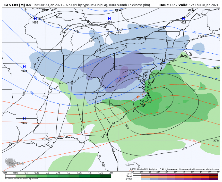
That GFS clown map ain’t got nothing on the GEFS. That’s a damn beat down my area north but also much colder and snowier solutions intermingled within the suite to get more people in the game IMO.
-
@ILMRoss GEFS looks much more “serviceable” and overall would deliver for a lot more people in the forum.
-
See and that’s the crappy part. I feel like the red headed step child. I’m literally in an area where either I’m almost rubbing salt in the wound for you guys or then in no mans land when DC crew is off their rockers because of too much confluence and you guys are cashing in to the south of me. Maybe we should just make a southern VA/northern NC forum and call it a day lollll. And I def understand the sentiment you share. I’ve been posting since the Eastern US weather board days. Only problem is I got to be in CT for all those, as I relocated down here like I said back in 2012. Posters like Typhoon Tip and ORHWxman are amazing and very knowledgeable people up that way. Def appreciate your insight on things.
-
I do think Ukie has to trend north now at this point but man has that model had a mind of its own over the years.