

Buddy1987
-
Posts
3,952 -
Joined
-
Last visited
Content Type
Profiles
Blogs
Forums
American Weather
Media Demo
Store
Gallery
Posts posted by Buddy1987
-
-
Pretty solid snow/sleet mix occurring right now. Starting to accumulate on everything, roads included. Not looking for much but it’s still winter weather
-
 1
1
-
-
Actually pretty decent snow/sleet mix here and starting to accumulate. Looks like rock salt out there lol. Any winter weather is a win
-
9
-
-
18 minutes ago, NorthArlington101 said:
If this works out (radar says it might) the Canadian suite has been on this.
Yes 100% agree with this. Was thinking all along it was way too far nw but even down this way I’m still at 23 and precip on my doorstep. Unprecedented if you ask me.
-
For me this is unprecedented as to what is occurring, specifically with the GFS. I mean not even close with precip. All the probs have been hiked up to 80-90% up this way and the temp is still sitting at 23.
-
1
-
-
3 minutes ago, NorthHillsWx said:
Globals are now trying to pop a decent coastal system Monday/Tuesday. Sadly, there is no cold air and it’s all rain
Need to will it about 60 miles more northwest up this way, as the 540 line is right on top of me. Interesting setup nonetheless
-
1
-
-
2 hours ago, WSchew said:
Poof

Dang that’s a crazy regression of what could’ve been.
-
1
-
 1
1
-
-
17 minutes ago, BornAgain13 said:
6z GFS still has a major ice storm this morning... 0z euro jumped on board with a little more snow/ice. We will see how this continues to go. UK still has it. The cmc is still not there...
Do you know if the Ukie was still amped? Also you saying the cmc is still not there made me laugh just for the fact of I’m not sure if it’s been there at all this winter. It’s still trying to figure out 3 storms ago.
-
1 minute ago, BornAgain13 said:
I put a lot more stock in the GFS since the upgrade.... whether it shows winter weather or not... its clearly better than it used to be...
Yea I would hedge large bets on gfs right now. It has been unreal so far this winter.
-
1 hour ago, WinterWxLuvr said:
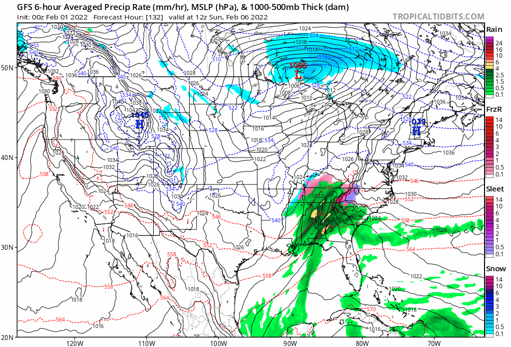
Your mention of the high being in Quebec sent me scurrying back to the model to look. At 90 hours gfs has surface winds out of the north that gradually begin to veer to the northeast. That’s big. Now you have cold pushing in and starting to bank against the Apps. At 850, northeasterly winds are just to our north. And I mean barely. Get those a little south of us and now snow appears as an outcome.
Model has really been adjusting last several cycles here to equate for the HP up top. That’s what I’m looking at next couple days here, as to whether or not that high gets even stronger or if it ends up sinking south some and really setting the stage for a nasty ip/zr event.
-
I’m not sure I ever recall a winter where spacing was this crazy. It’s like every couple days it seems there’s a storm on top of a storm. Maybe because it’s being alluded to this year but trying to forecast these things has got to be an absolute nightmare. Even the first storm, against the apps I.e SVA into NC mountains, at hr 90 the gfs has a 1045 high up over eastern Quebec. That even noses down slightly you have a dramatically different forecast. The low will not move plow into that thing and you can already see the last couple runs the low is readjusting to the cold air up top. This is a fascinating next seven days plus.
-
 1
1
-
-
Just now, clskinsfan said:
I know I am late to the party. Busy day at work. But like I was saying yesterday I dont see anything cutting into that 1050 HP. The models appear to be getting a grip on that part of it now. I would expect the boundary to come even further south if the HP is being modelled correctly. At least that my take on it.
I was literally just thinking the same thing. By hour 90 it’s still modeled to be at 1045 up in Quebec. Still good enough position, esp for our areas next to the apps. That is stout!
-
1
-
-
38 minutes ago, msuwx said:
Say what you will, having 3 winter weather events, to some degree, in 20 days is very impressive to me. Some spots in western NC had snow on snow on snow, which is pretty dang rare (I've never experienced it personally before), outside of the higher mountain spots.
This! I’m shocked we still have like a 3” snowpack in the backyard for 2 weeks now. Been a long time since I’ve seen that around this area.
-
2
-
-
Nice 1/2” outside. Colder concrete patio starting to cave out back. Temp down to 30.4. Better dendrites occurring right now in this band.
-
Nice moderate snow occurring right now. Temp down to 30.4 Solid 1/2” on the ground. Roads and concrete starting to get slushy. Can slowly see the snow starting to build on the colder concrete patio back of my house.
-
1
-
-
Nice little band starting to set up shop on a line from Covington down to Floyd VA. Will be watching this as night goes on. Snow starting to pick back up here.
-
1
-
-
2 minutes ago, clskinsfan said:

What a shot man. That is a classic look when I lived in NE for a nuke being dropped on top of us.
-
1
-
-
Dumping snow here. Temp down to 33 and grass is starting to turn white. Very nice dendrites in the heavier stuff
-
1
-
-
Dumping snow temp down to 33 and grass starting to cave.
-
2
-
-
Not sure what I was expecting but not overly enthused with the radar at the moment. Should we expect it to fill in decent amount toward sunset?
-
HRRR and NAM nest really like the 81 corridor with that band of snow that pivots overhead. Been showing for some time now.
-
@CAPE I hope you get nuked up that way! GL
-
2
-
-
@BornAgain13 NAMs insistent on pivoting that band through SVA nicely. 2-3” I would be absolutely elated.
-
45 minutes ago, StormyClearweather said:

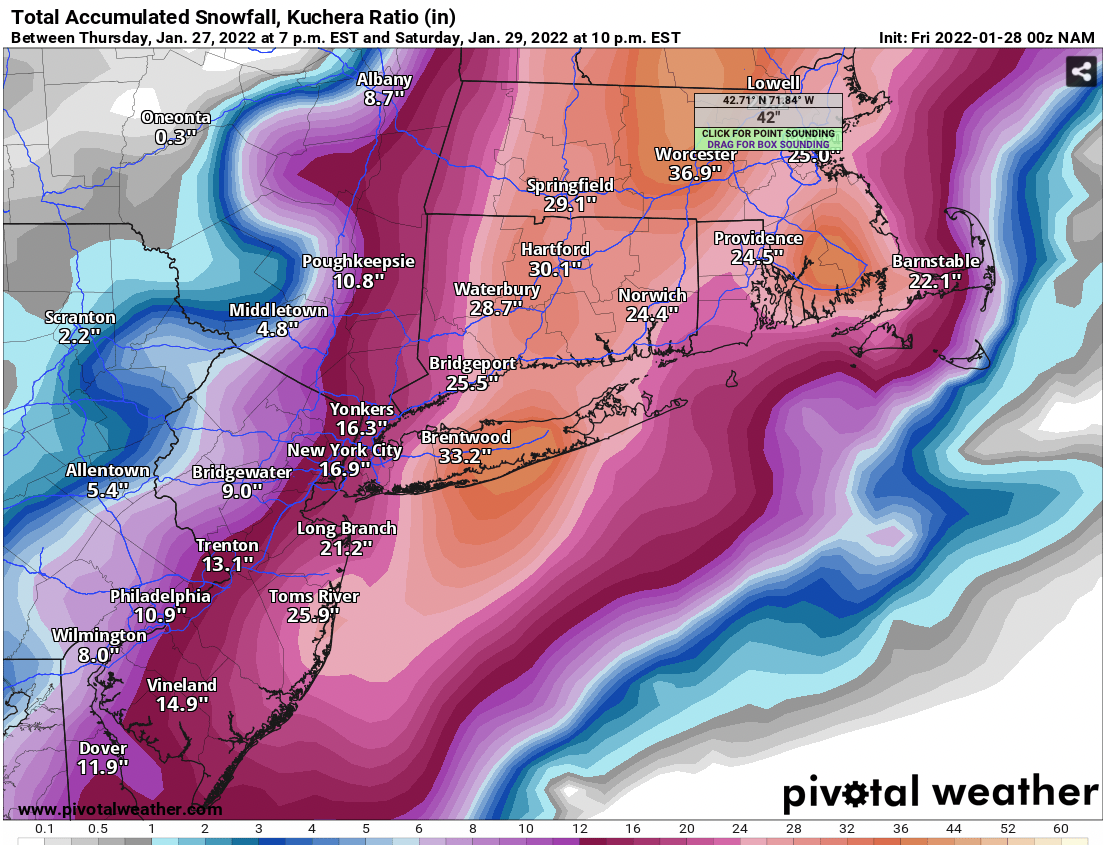
Just wild. But poor Oneonta.
Lived just north of Waterbury from birth up until 10 years ago. Still have a bunch of family there. Have had some absolute doozies up there. Most memorable one was 38”. It snowed 3-4”/hr for hours on end. Was incredible to see.
Missed this sob by one weekend. Was just up for a wedding last weekend. Man what could’ve been.
-
1
-
-
44 minutes ago, BornAgain13 said:
The 3k NAM snows at my house for 12+ hrs.

I was wondering if you were going to have some type of reaction lol. That was by far the best run of the 3k/12k combined for our state.
-
2
-
Mid to Long Range Discussion ~ 2022
in Southeastern States
Posted
I def wouldn’t esp for our latitude. 18z gfs actually looked tasty VA north