
Zelocita Weather
-
Posts
2,500 -
Joined
-
Last visited
Content Type
Profiles
Blogs
Forums
American Weather
Media Demo
Store
Gallery
Everything posted by Zelocita Weather
-
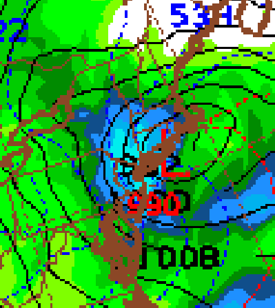
New NAM @ hour 75, Nuke, still snowing for much of the region with 2.0"+ QPF
-
 Not really, 6-12”
 -
Wow, this has well over a foot into S NJ, Philly, N Del, etc......impressive
-
I feel like many will be surprised tomorrow, especially just NW of the cities...with everyone concentrated on Wed/Thu, this storm normally would be getting quite a bit of attention, 0.5” LE or so, good amount of it snow....
-
-
NAM is juiced...
-
Ukie was 8” plus for all I95 and west from one model and one run....
-
Did GFS really up qpf with this or is it me, any snow maps from GFS?
-
What a run....
-
Gfs looks good...
-
Anyone have the snow map?
-
NAM looks decent
-
GFS looked good for 2-4” with this?
-
Sound similar to NAM with 1-2/3”
-
Do you have next frames, doesn’t look suppressed here...
-
Ukie and Euro for this storm?
-
Cold air and confluence is pressing here, storm will scoot south of us...storm can trend stronger, but with orientation of trough and pressing cold, can’t get too much more north (a la NAM that squashes it)
-
-
This setup is interesting, surface starts warm, but cold it is pressing smartly at same time coastal passes well to our south, could be 1”-2” for many
-
It’s a balance between the low position and the confluence/cold air, we have all seen a low pressure tucked onto the Delaware beaches, but NYC not see a flake due to confluence (Feb 5 2010); lots of fresh very cold air and a lot of moisture should make this at least a 6” storm, but very well could be 1’ plus...
- 3,762 replies
-
- 1
-

-
- heavy snow
- heavy rain
- (and 3 more)
-
January 2020 General Discussions & Observations Thread
Zelocita Weather replied to Rtd208's topic in New York City Metro
18z GFS, wow! Someone in NJ going to be pleasantly surprised Tom night/Wed -
January 2020 General Discussions & Observations Thread
Zelocita Weather replied to Rtd208's topic in New York City Metro
-
January 2020 General Discussions & Observations Thread
Zelocita Weather replied to Rtd208's topic in New York City Metro
GFS well westand a nice little event, NAM west as well
