

JC-CT
-
Posts
17,866 -
Joined
-
Last visited
Content Type
Profiles
Blogs
Forums
American Weather
Media Demo
Store
Gallery
Posts posted by JC-CT
-
-
On 2/7/2022 at 8:41 PM, Torch Tiger said:
20 days 'til met Spring! <3

-
 1
1
-
-
3 minutes ago, Cold Miser said:
Yeah. My 2" got sucked. lol
Congrats - doesn't really count if you do it yourself though
-
 4
4
-
-
So what's the latest with this little bitch? We getting some mood snow or what?
-
1
-
2
-
 1
1
-
-
Just now, 40/70 Benchmark said:
Guessing it looked better earlier in the run.
the trough was too broad
-
1
-
-
very confused why people think this looks better
-
1
-
-
15 minutes ago, TauntonBlizzard2013 said:
We don’t live at h5 oddly enough
speak for yourself
-
1
-
-
1 hour ago, Jmister said:
Have you looked into OpenGrADS at all? It's a versatile visual tool for all things grib.
Appreciate the response. I did attempt to use opengrads but the stupid turtle kept crashing on me whenever I would generate a CONUS map, so I'm basically having some fun recreating the wheel.
-
12 hours ago, JC-CT said:
I reverted back to python, having some limited success making my own GFS and euro maps from the raw data. Need to figure out if I can do anything useful though.
500mb heights - today's 6z Euro at hr 90 vs today's 0z Euro at hr 96
I downloaded grib files directly from ECMWF (so lower res version)
Need to figure out how to add labels and such

-
1 hour ago, tamarack said:
Somewhat different at our latitude, at least through the first half of the month. The 23-year average for snowpack here currently peaks at 21.6" on 3/2 and is still at 12.0" on the 31st. It was up to 27" this morning but the present light rain may push it down a bit during the day.
Agree to the bolded part, but also the italicized part is basically giving you an extra week or two padding if accurate. But down here where Wolfie is, it's right around the turn of the month, maybe after the first week, that it starts becoming more likely that you aren't going to be able to maintain a pack for long.
1 hour ago, ORH_wxman said:Even where I am, I frequently have snow pack in the first couple weeks of March. It's more common to have pack here in early March than it is for most of December. It definitely changes after the first couple weeks.
Right, I don't think that's inconsistent with what I'm saying - not for @WinterWolfin Southington, CT. If we are talking a difference of a week, I don't think I was trying to be that precise...he said "months left of winter" and I'm saying "nah son, it's called spring." It still snows in spring. But in most of CT, maintaining a pack in spring, even early spring, for an extended period of time (like for 2 weeks) is difficult and gets exponentially more difficult each week you go past March 1st. And while it might snow, you are still going to get a DD day or two that makes you remember that this snow-loving hobby is really just a way to get through winter with your sanity.
2 hours ago, Cold Miser said:Except for March 93. I remember driving from R.I. to DC a few weeks later, and snow was still down there.
Always exceptions to the rule, definitely.
-
2 minutes ago, WinterWolf said:
I guess some are fatigued. I can understand. It’s been a lousy run for some of us.
But there’s no getting out on 2/8 when you live in Southern New England. So it’s gonna be a long few months. Cuz after the next 6 weeks passes, and the snow chances are gone at the end of March, we have another 6 weeks of damp raw misery mist for the most part.
So while it’s still very much winter, and the height of it at that, doesn’t hurt to check in once in a while, and see if anything interesting is brewing. I wouldn’t be wasting much time in here, but a check doesn’t hurt.
We are less than a month from meteorological spring. Snow in March isnt the same as snow in January...whatever falls in March has an expiration date of under a week.
-
1
-
-
It's actually my 1/7 layer that is holding out lol. But soon, thank god. Upcoming week looks great.
-
On 2/4/2022 at 8:58 PM, JC-CT said:
Does anyone here mess around with GRIB data at all? I got the urge today to try to match up GFS temps to actual observations from the RTMA to see just how bad it was. But it was a little funky trying to match up the grid resolutions and also the GFS is apparently terrible with surface temps over water (that, or the RTMA data is bad for that) so I have to filter my coordinates a little better. But it was interesting...as you might expect, it busted badly on the cold side over land. Need to do a little more validation, might play with it some more over the weekend.
Graphing it is a whole other story too...I did initially play around with some prebuilt stuff but I eventually gave up on that, and on python, and fell back on my reliable old self-taught .NET so I'm sure I'm recreating the wheel on a bunch of stuff. At least there was a nuget wrapper available called grib.api.
The cool thing is that all the weather models and agencies seem to use it. Although trying to work with RAP data was giving me fits.
I reverted back to python, having some limited success making my own GFS and euro maps from the raw data. Need to figure out if I can do anything useful though.
-
20 minutes ago, jbenedet said:

do 850 next
-
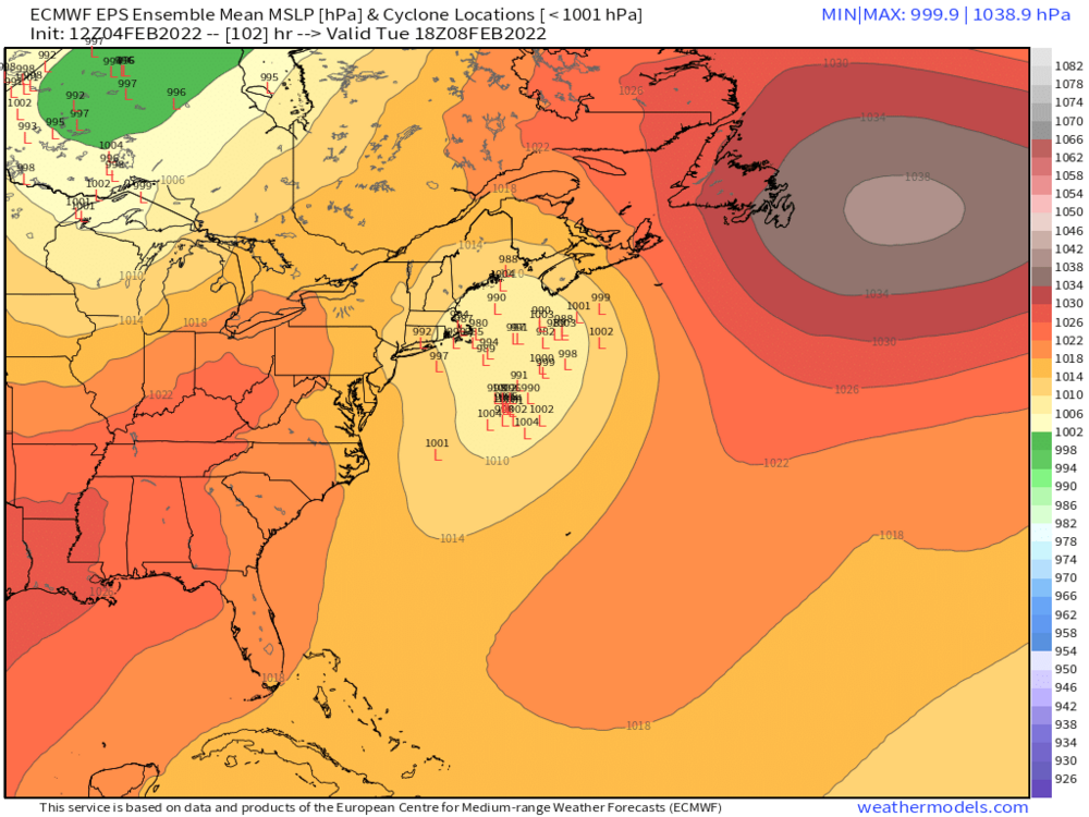
Just now, CoastalWx said:
What a back alley setup this is. All this stuff is a sign of the airmass above us really warming. And right when the low cranks, there is no cold to wrap in.
yeah, it sucks
-
1 hour ago, EastonSN+ said:
Hmmm. What does this look like (special thanks and regards to the MA thread).

a 192 hour clown map using clown ratios
-
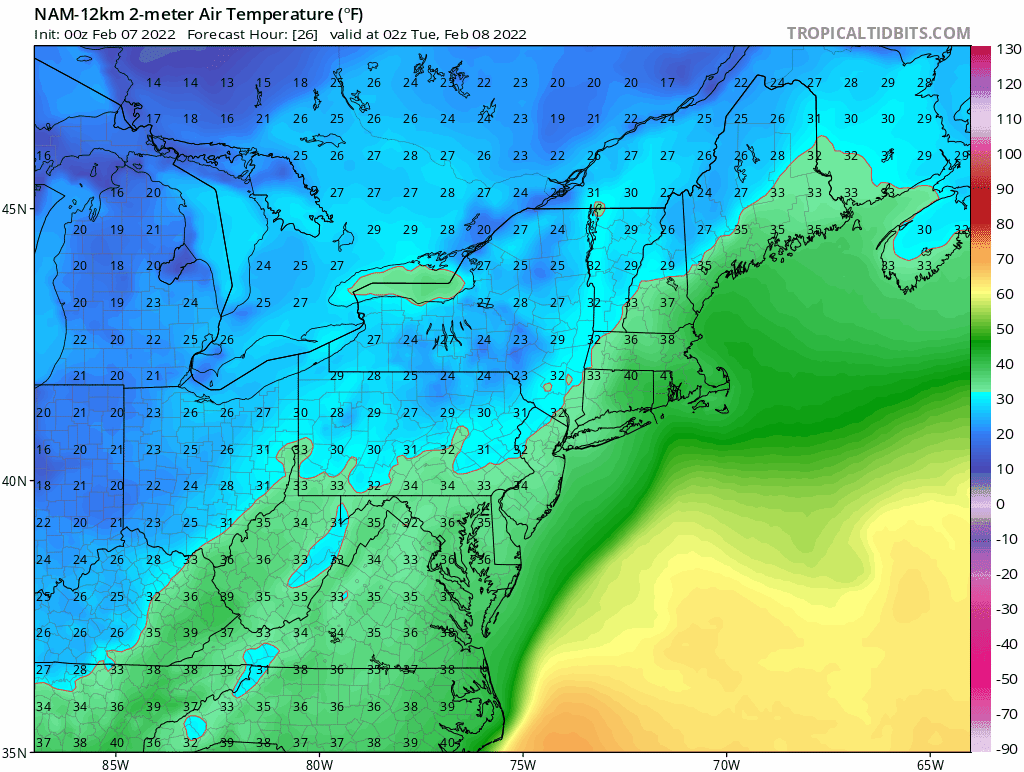
5 minutes ago, ineedsnow said:
if you click the soundings on pivotal most are around 30 to 31 at the surface
Glad to see ineedsnow teaching coastalwx about the existence of soundings. Must be looking good.
-
1
-
-
10 minutes ago, Ginx snewx said:
I left Columbia to little snow and glaze to full pack, plowed roads from sleet and a frozen world. Totally different
In many ways
-
-
Everything coated up again.
-
Looks like those upper levels finally cooled off, and just in time!
-
1
-
2
-
-
6 hours ago, ORH_wxman said:
EPS has a lot of good-looking members....but most of these are rain outside of ORH county into CNE/NNE. The low levels are trash.
This is why it's hard to care about this one. Would need to create its own cold air, and it needs so much work to become that level of storm.
-
Does anyone here mess around with GRIB data at all? I got the urge today to try to match up GFS temps to actual observations from the RTMA to see just how bad it was. But it was a little funky trying to match up the grid resolutions and also the GFS is apparently terrible with surface temps over water (that, or the RTMA data is bad for that) so I have to filter my coordinates a little better. But it was interesting...as you might expect, it busted badly on the cold side over land. Need to do a little more validation, might play with it some more over the weekend.
Graphing it is a whole other story too...I did initially play around with some prebuilt stuff but I eventually gave up on that, and on python, and fell back on my reliable old self-taught .NET so I'm sure I'm recreating the wheel on a bunch of stuff. At least there was a nuget wrapper available called grib.api.
The cool thing is that all the weather models and agencies seem to use it. Although trying to work with RAP data was giving me fits.
-
16 minutes ago, Snowcrazed71 said:
It is 32 here now.
Are all heres the same here?
-
I'm not convinced I will ever go below 32F again. Ever.
-
1
-


Feb 13-14 snowstorm/nor’easter potential
in New England
Posted
It's also the kind of dynamic in which a place like DC or RIC often needs