

JC-CT
-
Posts
18,191 -
Joined
-
Last visited
Content Type
Profiles
Blogs
Forums
American Weather
Media Demo
Store
Gallery
Posts posted by JC-CT
-
-
2 minutes ago, Sey-Mour Snow said:
wow really?
Yeah, but precip has been light
-
-
-
1 minute ago, Greg said:
It seems to sound like he's taking that from the HREF mean that was posted.
A rip and reader, he is not
-
I wonder how Ryan is feeling about going 6-9 for most of CT
-
-
EPS still trash. Heavy chances of trash
-
 2
2
-
-
There's enough there for the 24th on the GEFS to keep me interested for another few cycles
-
1
-
 1
1
-
-
2 minutes ago, CoastalWx said:
Lmao at the RGEM. Please don’t ever mention that model again. We knew.
Oh Canada!
-
6 minutes ago, RUNNAWAYICEBERG said:
If we drew a map, it would basically look like this clown.
The issue is that especially west and/or in the hills, anything higher than 10:1 is going to bust your forecast low
-
-
3 minutes ago, Damage In Tolland said:
I was thinking more like CT. I wonder if he thinks his area is getting 2”?
2-5 doesn't mean 2 everywhere. But yeah I think there's a risk of busting low on both ends.
-
1 minute ago, Damage In Tolland said:
Who is getting 2-3”?
Most common numbers will be 6-8” over a wide swathThe shoreline, especially east, could definitely struggle with temps
-
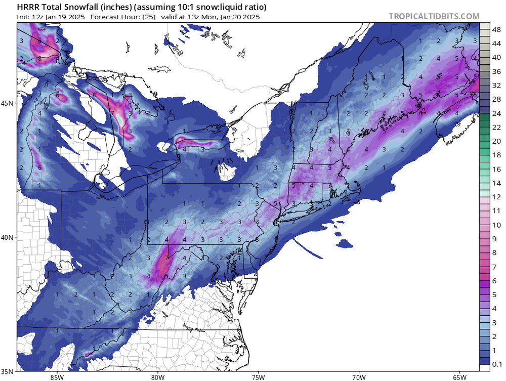
NAM precip field looking much healthier so far than 6z. I will say, the current radar looks better than 6z had right now too. Especially up in PA.
-
1
-
-
2 minutes ago, ineedsnow said:
I think ratios will have to be really good to reach that.. Hopefully we get some good banding later on
Even then, someone has to actually be awake to measure it before it compacts. I don't know about you, but I'm not waking up at 3am to measure for this one.
-
1 minute ago, ineedsnow said:
Not really it was nice to see and I was hopeful.. but knew the whole time it was out of reach when every model wasn't on board.. seems lately we decrease closer in
This is an open wave, not a ku setup. We missed our ku last week.
-
2
-
 1
1
-
-
4 minutes ago, ineedsnow said:
.thumb.png.f694fcff3c1633bb46ec2c9a6a068104.png)
This is not completely done up north btw
-
1
-
-
On 1/17/2025 at 2:09 PM, JC-CT said:
3-7, ez
Ez
-
2 minutes ago, ineedsnow said:
Just went to market basket and it was wicked icy.. didn't slide anywhere but salt trucks were out everywhere.. 12z HRRR = meh
It looks fine, if you have reasonable expectations
-
1
-
-
Just now, RUNNAWAYICEBERG said:
AI knows. Embrace it and let it into your lives.
It's amazing, and also infuriatingly stupid.

-
4 minutes ago, ORH_wxman said:
At the end of the day it looks close to a typical 70/30 euro win. Unless this can tuck in a bit more than guidance currently says. It’s still a decent event but widespread 8-12 with higher lollis doesn’t look very likely which is basically what GFS/Canadian guidance had at one point (with much less near coast)
Euro OP wasn't good either, and also drank some kool-aid at 12z yesterday. What seems to have done very well is the skynet.
-
1
-
-
6 minutes ago, ORH_wxman said:
HRRR and RAP are pretty weak sauce at the moment. I’d like to see them ramp up a bit today.
Yeah feels pretty easy to take the under on big totals
-
2
-
-
34 minutes ago, ORH_wxman said:
I was only half-kidding when I said Scooter to Tblizz might jackpot this. There’s a period where that zone could absolutely rip for 3 hours or so. If they get into one of those bands that’s 2-3”/hr, all bets off.
I think there’s going to be an initial weenie band west out toward our friends in W/C CT and then things are rapidly going to try and congeal to the east.
19 minutes ago, 40/70 Benchmark said:My take.

So...

-
 10
10
-
-
2 minutes ago, weathafella said:
18z NAM seems to slow it down. Brings it over the bowel movement 34-36 hours at 992 and widespread good snow. Much better qpf field.
Still a big difference between 12km and 3km
-
1
-


.png.b68359665cce9d5d99c917f858b580ca.png)

As WAR expands, do our snow chances increase? First wave may produce a middling event-solid advisory and possible low end warning for MLK Weekend
in New England
Posted
I'm going to launch a new $blizzard meme coin, yall in?