

IWXwx
-
Posts
6,441 -
Joined
-
Last visited
Content Type
Profiles
Blogs
Forums
American Weather
Media Demo
Store
Gallery
Posts posted by IWXwx
-
-
19 minutes ago, Hoosier said:
I'd hate to be working outside in Kankakee today. 90/82 there. Oof
ChicagoWX must be wringing his shirt out a lot today
-
Snippet from IND's discussion this afternoon. I didn't realize that it has been 10 years since the area got into the upper 90's.
THE LONG TERM WILL START WITH POSSIBLY THE HOTTEST TEMPERATURES IN
NEARLY A DECADE ACROSS CENTRAL INDIANA.
-
25 minutes ago, Powerball said:
Can I please have the link to that site?
I'd like to use it as well.
I believe he's using this:
-
 1
1
-
 2
2
-
-
It's pretty impressive when your days 4 and 5 point forecast is 97°, especially in mid-June.
EDIT: Both 98° now

-
1
-
-
Debris signature on the warned storm in Rush Co. IN.
-
31 minutes ago, nwohweather said:
Rejoining you guys for a week here on a work trip. What the hell is this Low 70's stuff?
Feels great. Too bad that you won't be here next week for our mid 90's.
-
We missed rain to the southeast earlier and now whiffing to the northwest with flooding rains. Hopefully will see some scraps later tonight.
-
1
-
-
3 hours ago, A-L-E-K said:
Top shelf weather day
Ditto here
-
14 hours ago, Hoosier said:
Tornado has been reported. Actually had PDS wording in the text.
You and ChicagoWX’s buddy Chad called out IND on NWSChat last night for calling it a “large and dangerous tornado” when it was clearly a small and weak one (landspout?). They said they issued based on info they had at that time, that they were very busy, that they issued a regular warning 10 minutes later, and finally gave half-hearted mea culpa.
-
 2
2
-
-
One tornado, two states. The ef-2 damage occurred in Illinois. It was on the ground for quite awhile.
...NWS DAMAGE SURVEY FOR MAY 19 2022 TORNADO EVENT...

.WABASH COUNTY ILLINOIS TO GIBSON AND KNOX COUNTIES IN INDIANA...

RATING:                 EF-2
ESTIMATED PEAK WIND:    115 MPH
PATH LENGTH /STATUTE/:  26 MILES
PATH WIDTH /MAXIMUM/:   300 YARDS
FATALITIES:             0
INJURIES:               0

START DATE:             MAY 19 2022
START TIME:             931 PM CDT
START LOCATION:         0.6 MILES SOUTHWEST OF KEENSBURG ILLINOIS

END DATE:               MAY 19 2022
END TIME:               957 PM CDT/1057 PM EDT
END LOCATION:           0.4 MILES WEST OF IONA INDIANA


SURVEY SUMMARY: NUMEROUS TREES WERE UPROOTED OR SNAPPED OFF, MANY
OF WHICH FELL ON HOMES AND STRUCTURES. DOZENS OF POWER POLES
SNAPPED OFF. MINOR STRUCTURAL DAMAGE TO BUILDINGS. SEVERAL PIVOT
IRRIGATION SYSTEMS FLIPPED.
-
1 hour ago, frostfern said:
What do y’all think of the chance for supercells tomorrow afternoon over Lower Michigan. Im thinking of driving up to Gaylord as the higher terrain seems more likely to break the cap. I’m thinking if something can get going it has the chance of dropping plains-style hail which is rare around here. It could also be a cap bust though.
I'm not trying to talk you out of it, but Stebo's right about crappy chasing territory and SPC's being pretty wishy-washy about the possibility of something popping the cap. But if it happens, Katie bar the door (and protect your windshield).
-
3 hours ago, Hoosier said:
First 90+ at Midway today. Looks like ORD will come up short with either 88 or 89.
You called that one.
The real heat isn't going to reach this far east, but I'll take my low-mid 80's for multiple days.
-
I'm happy with finally having a pattern change that truly flips sensible weather from cool and rainy. I just checked my CoCoRaHS records and realized that until yesterday, we have had at least a trace of precip in 38 out of the past 50 days.
That includes a stretch of 16 days in a row (3/30-4/14) and 22 out of 23 days (3/23-4/14) with at least a trace.
I'd say that's a legit complaint. Now on to summer!
-
1
-
-
9 hours ago, bowtie` said:
KIND says gusts in the mid 20's for the next three days. Actually for Spring, that is not too bad. Should not have trouble getting the kite to fly if you so choose.
Yeah, well I expect it in March and April, which were in fact quite windy. But we're barreling through May with yet still almost daily winds gusting over 20 and many days 30. Guess I should have taken it to the complaint thread, in which I'm about to post another complaint concerning precip and clouds.
-
1 hour ago, Chambana said:
Summer mode 100% engaged. Getting the pool filled next week, the smell of grills in the air, and everyone in the neighborhood is chipper and out walking.
I absolutely love this time of year, as you know summer is near and the humidity is low. Absolutely top shelf day.
Dad and I are cooking all the women steaks and twice bakes, finally for the first time this year everyone is outside enjoying the weather with no wind.
Bring on summer 2022!
I'm looking forward to no wind. It was very gusty here again today.
-
3 hours ago, Hoosier said:
That's a lot of drought.
We are sort of due for some triple digit heat. Many areas in the sub have not seen that since 2012.
FWA hit 100° in 14 years since 1909, or about once every 8 years, so yeah, we're due.
The longest stretch they went without hitting 100° was 17 years (1963-1979).
They also hit 99° nine times since 1909, which equates to once every 5 years of hitting at least 99°.
Since 2012, the yearly highs at FWA have been fairly pedestrian:
2013-95°
2014-93°
2015-90°
2016-94°
2017-95°
2018-97°
2019-95°
2020-95°
2021-92°
-
11 hours ago, King James said:
5 straight weeks of trash weather. Quite an impressive run
And it's no better to your south. IND posted this little tidbit on their FB page:
"It's been a cool stretch into April so far with no 70° days. Last time this happened was 1990 when the first 70° day didn't happen until the 22nd."
-
 2
2
-
-
My daily gauge readings for April. How about a pattern change that actually alters sensible weather?
0.13 T 0.07 0.10 0.03 0.06 0.35 0.06 0.05 0.04 0.03 0.04 T 0.72 0 -
1
-
-
-
I just read an article that discussed "Tornado Alley" now including more southern states. Without getting into a debate about what constitutes tornado alley, the following was tacked on to the end of the article that caught my attention:
"As these storms increase, what can we do to prepare for them?"
"Recently, legislation was introduced to improve tornado forecasting and warnings. This bill has been in the works for a while but has advanced by a Senate committee. It would require the National Oceanic and Atmospheric Administration to evaluate its IT infrastructure to get information out to the public faster."
"NOAA is working to simplify how alerts are communicated to make them easier to understand while also taking into account the socioeconomic factors that put people at risk. The goal of the new bill would make warning times go from 15 minutes to one hour, giving people more time to find shelter."
I'm shocked, shocked I tell ya, that passing this legislation will in of itself advance the science of predicting tornadoes to an hour ahead of time. Holy low verification scores/warning burnout.
-
3
-
-
2 hours ago, Hoosier said:
Saturday looks like a big loser. Hopefully the really crappy weekend days are limited from here on out.
Well, at least there's this to look forward to on Friday:
As the low broadens and shifts into the MI/OH/Lake Erie area during
the day Friday expect to see a wintry mix of precipitation with
continued raw and breezy conditions through the afternoon and
evening. With the location of the low and the slow movement there is
a possibility for convective instability to support graupel and
possibly even some thunders snow...but the confidence of exact
timing and location is uncertain. With abundant cloud cover GFS
MUCAPE increases briefly to over 400 over NE IN/NW OH...but again a
LOT can change with the model runs and have introduced a slight
chance of -T for a brief period Friday afternoon/evening.
-
1
-
-
Dropping parachutes right now, giving a quick dusting. This would be pretty cool in November through February. In April? Naso much
-
1
-
1
-
-
13 hours ago, IWXwx said:
Only 0.13" here last night too. lol
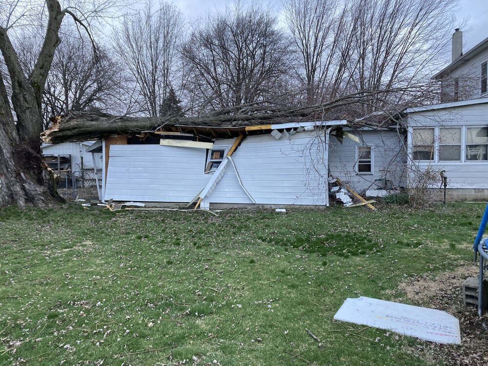
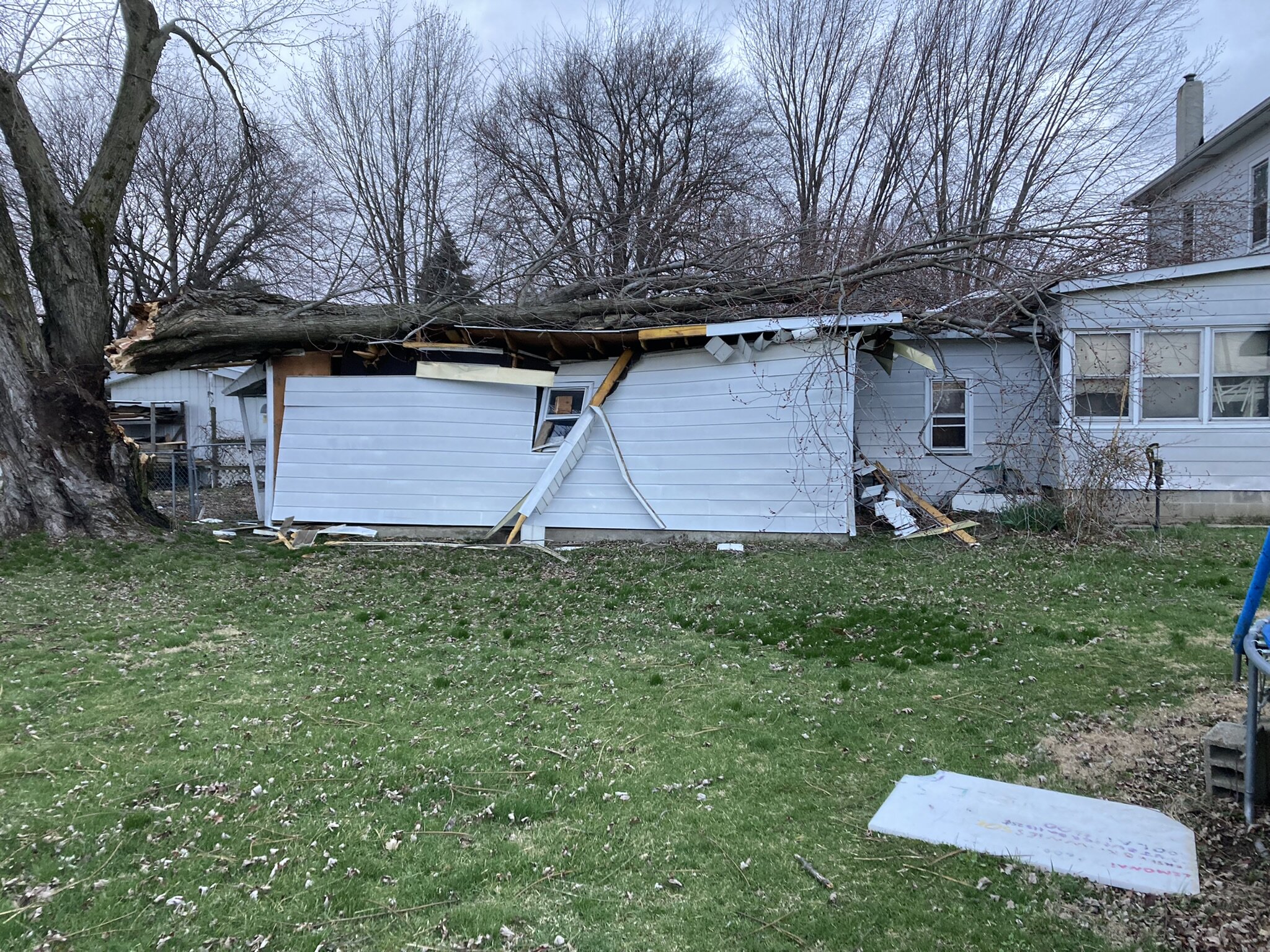
We did get some serious winds mixed down this morning between 5 and 6 AM with several gusts measuring between 55-65 MPH across northeast Indiana. I have to go survey a couple of damage reports, one destroying an attached garage.
2 hours ago, cyclone77 said:Ended up with 0.70" total as the deformation precip exploded overhead last night. Also picked up 0.3" of wet snow, which was enough to bump us over the 19" mark for the season.
We are getting some light rain this evening and is trying to flip to snow, but we'll see no where near 0.70". Also, this happened a few blocks from my house at 5 AM this morning.
-
2
-
-
12 hours ago, cyclone77 said:
Only 0.13" here today.
Only 0.13" here last night too. lol
We did get some serious winds mixed down this morning between 5 and 6 AM with several gusts measuring between 55-65 MPH across northeast Indiana. I have to go survey a couple of damage reports, one destroying an attached garage.
June 13 Severe Event
in Lakes/Ohio Valley
Posted
Watching the Field Museum earth cam. Constant lightning. Alek's getting a show