

IWXwx
-
Posts
6,438 -
Joined
-
Last visited
Content Type
Profiles
Blogs
Forums
American Weather
Media Demo
Store
Gallery
Posts posted by IWXwx
-
-
LOL
433 PM CDT Fri Mar 25 2022
...A SEVERE THUNDERSTORM WARNING REMAINS IN EFFECT UNTIL 500 PM CDT
FOR NORTHWESTERN WILL AND SOUTHERN DUPAGE COUNTIES...At 432 PM CDT, a severe thunderstorm was located near Naperville,
moving east at 50 mph.HAZARD...70 mph wind gusts and small hail.
SOURCE...Radar indicated. This shower has a history of producing 70
mph winds!IMPACT...Expect considerable tree damage. Damage is likely to mobile
homes, roofs, and outbuildings.Locations impacted include...
Aurora, Joliet, Naperville, Bolingbrook, Downers Grove, Romeoville,
Plainfield, Woodridge, Lockport, New Lenox, Homer Glen, Mokena,
Lemont, Burr Ridge, Westmont, Lisle, Darien, Crest Hill, -
49 minutes ago, Hoosier said:
Later on could get a little interesting from a squally perspective. SPC even has a general thunder area.
I threw up a Facebook post on our EMA page this morning warning of quickly changing visibility with some squalls. Fortunately, it will be in the late evening/AM hours down here, so will hopefully be low impact.
-
I'm surprised no one is considering driving to central OH this afternoon. Good chasing terrain for the most part.
-
 1
1
-
-
A solid D here. The only thing that saved this winter from an F was the early February 12 incher. Take away that storm and I'd barely be in double digits and FWA would still be in single digits.
-
Some cellular LES made it clear down here this morning. We even had a some substantially reduced visibilities at times. Pretty cool. A nice way to finish winter. Now looking forward to 50's and 60's all week. Bring it!
-
2 hours ago, cyclone77 said:
Even with temps well below freezing most of the snow melted today.
Looks very quiet for the next 10 days or so.
Time to go on daffodil watch with the warmer temps on the way. They should start knifing through the top soil in the next 10 days.
The same thing happened with the snow here. Also, I just noticed today that some of my tulips leaves are poking up. They should really take off this week.
-
1 hour ago, CheeselandSkies said:
I think I heard this story once before, although the date on the article is current. So did Casey just abandon it on some random Kansas farm and the owner didn't notice for 10 years?
Apparently, although the article ambiguous/fuzzy about that.
-
Anyone want a fixer upper for chasing?
-
 1
1
-
-
On 3/6/2022 at 5:34 PM, Hoosier said:
You may be done with winter, but winter is not done with you.
4 hours ago, Chicago WX said:In IKK too. Just took the dogs out and went and measured 3.8". And still snowing. Nice surprise.
Hoosier thread starter ftw
Only about an inch and a half here, but it's more palatable knowing that the entire next week will bring spring in its full glory.
-
Wet? CPC says mmmaybe.


-
10 minutes ago, tuanis said:
???
Yeah, you're right. That was kind of a southern part of the forum/IMBY post.
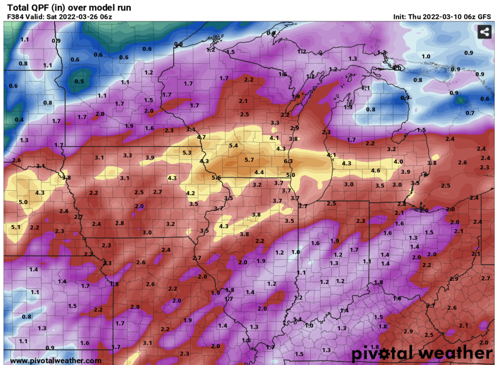
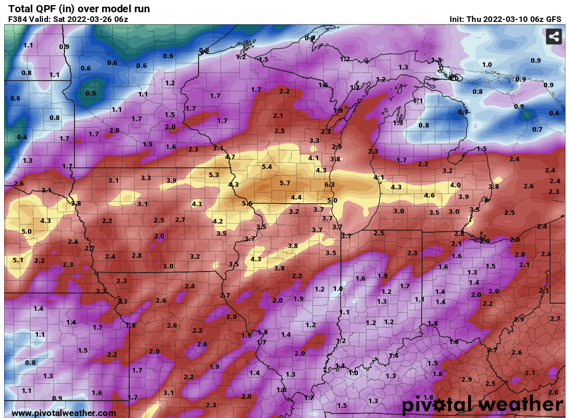
EDIT: I just quickly checked the ensemble means when I made the post. However, I also take a deterministic GFS total precip map through 384 with many grains of salt. If they were accurate, I would have been buried in snow from late January through February this winter.
-
1
-
-
1 hour ago, Chambana said:
Winters last gasp this weekend? Next week looks mild and dry.
Yeah the gfs depicts a zonal flow pretty much after this weekend through the end of its run. Fairly seasonable and dry, or to put it more succinctly, zzzzzzzzzz
-
12 hours ago, cyclone77 said:
Finished with a lowly 1.5" so up to 17.5" now.
Dang! You might catch me with one more snow.

-
Indiana is on the board for a tornado as a survey revealed an EF-0 in Cass County, although there were reports of stronger straight-line winds in the area than the tornado produced. However, it did damage a house.
PRELIMINARY LOCAL STORM REPORT NATIONAL WEATHER SERVICE NORTHERN INDIANA 709 PM EST SUN MAR 6 2022 ..TIME... ...EVENT... ...CITY LOCATION... ...LAT.LON... ..DATE... ....MAG.... ..COUNTY LOCATION..ST.. ...SOURCE.... ..REMARKS.. 0205 AM TORNADO 4 SW ROYAL CENTER 40.82N 86.55W 03/06/2022 CASS IN NWS STORM SURVEY NWS SURVEY CONFIRMS A BRIEF, EF-0 TORNADO TOUCHED DOWN NEAR THE INTERSECTION OF W CR 400 N AND N CR 925 W. THE TORNADO TRACKED NORTHEAST FOR ROUGHLY A HALF MILE CAUSING DAMAGE TO TREES AND A HOME BEFORE DISSIPATING. WINDS ARE ESTIMATED AT 70 MPH. -
1 hour ago, A-L-E-K said:
$$$ as usual

-
3
-
-
This sucks. Six dead and four injured.
-
 1
1
-
-
Had legit 65MPH winds as it moved through. Multiple poles down in the area as well as a semi on its side on I 69.
-
RECORD EVENT REPORT
NATIONAL WEATHER SERVICE INDIANAPOLIS IN
440 PM EST SAT MAR 05 2022

...RECORD DAILY HIGH TEMPERATURE SET AT INDIANAPOLIS...

A RECORD HIGH TEMPERATURE FOR MARCH 5TH OF 77 DEGREES WAS SET AT
INDIANAPOLIS TODAY. THIS BREAKS THE OLD RECORD OF 75 SET IN 1956 AND
TIED IN 1983. WEATHER RECORDS BEGAN IN INDIANAPOLIS IN FEBRUARY 1871.
-
Who's heading to Iowa this afternoon/evening?

-
1
-
-
1 hour ago, Hoosier said:
Drove past a few gas stations and they are all over $4/gallon... that is about the highest I can remember it being around here. Wouldn't be surprised if the more expensive areas reach $5 in the not too distant future.
We're living through some interesting times.
All of the stations in the Ft. Wayne area are at $4.00 today (well, technically $3.999 lol). I remember in 2011-'12 it hovered at around $3.80 for a prolonged period of time.
-
The yoopers measure in inches. Down here I'm on my knees in front of my snowboard trying to get every last tenth. Bo gets more settling from one storm than my yearly total!


-
2
-
-
1 hour ago, cyclone77 said:
66 at MLI today, 59 here. Should hit 70 Saturday as long as clouds don't coc k block too badly.
Only expecting upper 60's here, but I'll take it.
-
2
-
-
16 minutes ago, bowtie` said:
Finally, a death knell for winter. The sandhill cranes were honking their way back north today. A good sign.
I saw a flock a couple of days ago and had my first robin singing to me this morning as I went into the office (well, not exactly singing, but making the noise they make when they're pissed off at you).
-
3
-
-
On 2/24/2022 at 6:20 PM, cyclone77 said:
How much snow have you had up there? Had about 14" here so far not counting what's coming from the current storm. Dubuque only at 15.5" or something. Looks like Rockford below 15" as well. Just a sad, sad winter lol.
The ONLY thing saving this crappy winter for me was GHD3, where I pretty much bulls-eyed with 12.3". You take that away and I would be sitting at 9.9". This brings up the discussion of whether you are happier with one big dog or just general snowy and cold throughout the winter. I want both!
Back to the thread topic, as it is discussed every year as we roll into March, some are ready to go into full-blown spring, while others are hoping to salvage winter, no matter how awful it's been up to this point. I guess that I fall into the latter category, as I use astronomical spring as the cutoff. So, winter, you have three weeks to redeem yourself. That being said, the upcoming week looks zzzzzz with a mini torch next weekend, so let's make that two weeks.
March 2022 General Discussion
in Lakes/Ohio Valley
Posted
We had mood flakes off and on all day yesterday, that mood being a sour one.