

cstrunk
-
Posts
574 -
Joined
-
Last visited
Content Type
Profiles
Blogs
Forums
American Weather
Media Demo
Store
Gallery
Posts posted by cstrunk
-
-
1 hour ago, aggiegeog said:
Yesterday the rain was to my north and today to the south, ugh.
Same here. It does look like the outflow from this morning convection to the south has stalled near or just north of Longview, and there is an area of agitated cumulus that may turn into a few storms/showers with continued strong insolation along the boundary.
-
23 hours ago, cheese007 said:
Been missing the rain so this morning's showers are a very welcome sight
Ditto, except we haven't had a good shower yet. I'm hoping to cash in on one today yet before it dries out for a while again.
-
It's been dry IMBY since the bonus rain last week. It finally feels like mid-late summer here, with temperatures in the upper 90's today and through the extended forecast, and no rain expected.
I'll have to water my lawn this weekend for only the 2nd time all year!
-
 1
1
-
-
Cashed in on 0.50" of rain yesterday afternoon, and 1.85" early this morning in a storm that woke me up. Great timing as I could tell my grass was beginning to fade a bit from it's lush green nature I have enjoyed all spring/summer so far. I've only watered one time all year.
-
42 minutes ago, aggiegeog said:
It packed a punch wind wise. Still dealing with issues from it at the office in downtown Tyler.
We had about 45 mph gusts, but only received a few sprinkles IMBY. Disappointing combined with the forecasted track of Barry shifting farther east. We probably won't end up with much from that either.
-
Surprise, surprise, the MCS from KS is knocking on my door.
-
4 hours ago, Snow88 said:
Euro has a Cat 1 into the border of LA and TX at 144 hours
Quite a westward shift. Obviously still a long ways out, but at least it's something interesting to follow. Flooding will likely be the biggest threat (barring major intensification), but fortunately east Texas and LA haven't received as much rain recently as they did in spring, for the most part.
-
1
-
-
I agree with SPC concerning the tornado threat, my concern is for potentially wind-driven very large hail. That would be no fun.
*edit - Towers are going up north of DFW. Initiation seems likely soon.
-
9 minutes ago, aggiegeog said:
In the Tyler area I had a strong line around 5am that later went severe east of me. Looks like some strong storms this evening into tonight again for my area.
There was a tornado warning near/west of Marshall, TX and there were reports of wind damage, it wouldn't surprise me to have a survey crew confirm a tornado in that location.
I had some strong winds in Longview from that line, but I think the worst winds hit just north of me.
Models are showing supercell initiation in the 5-7 PM time frame this evening near and NE of the DFW metro.
-
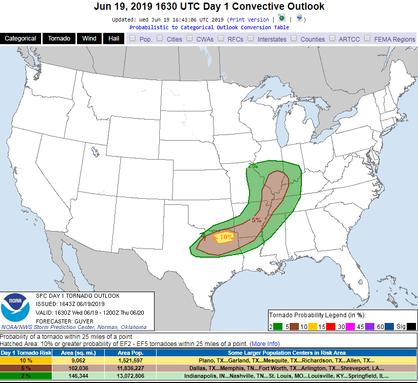
5 hours ago, cheese007 said:
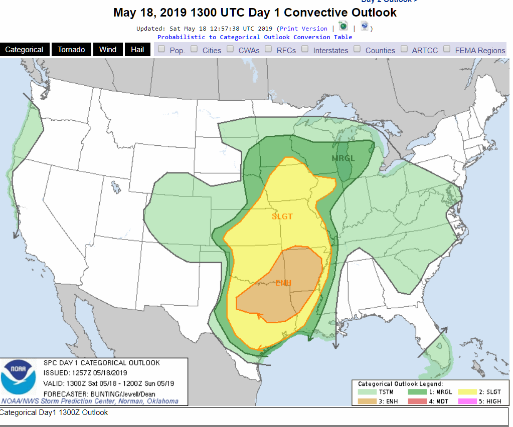
D1 enhhanced for the DFW metro with 5% tor probs.
SPC added a small 10% area for initial supercell development expected late this afternoon/early evening just northeast of DFW. Larger area of hatched hail/wind probabilities as well. The storms are expected to quickly merge into a southeastward moving severe MCS.
-
https://www.spc.noaa.gov/products/md/md0876.html
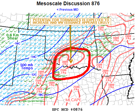
Tornado watch likely incoming for north-central and south-central Oklahoma...
-
Just now, jpeters3 said:
It's quite probable that the two are related (i.e. width and intensity are correlated). I'm fairly sure I've seen some research evidence to support this.
Two tornadoes could have the same wind speed but a mile wide wedge is going to have a much longer duration than say a 100 yard wide tornado... thus more opportunity to inflict damage.
-
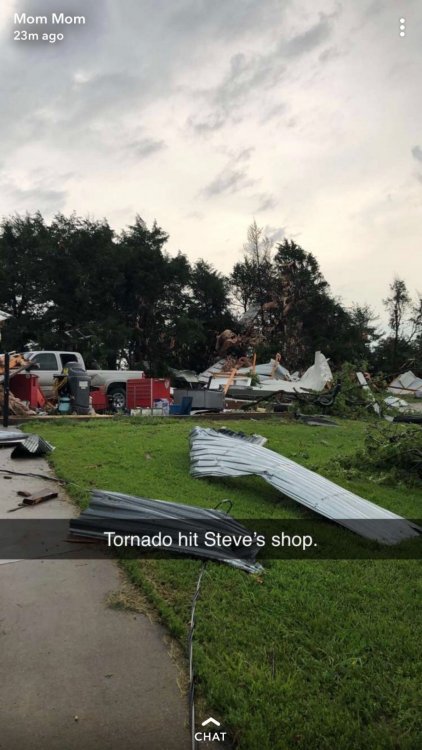
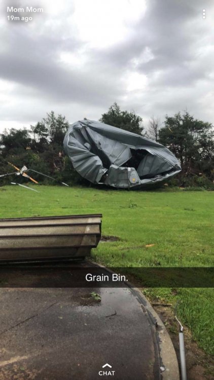
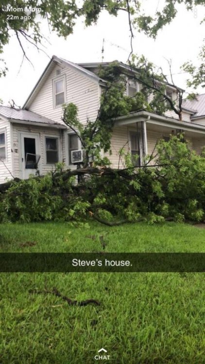
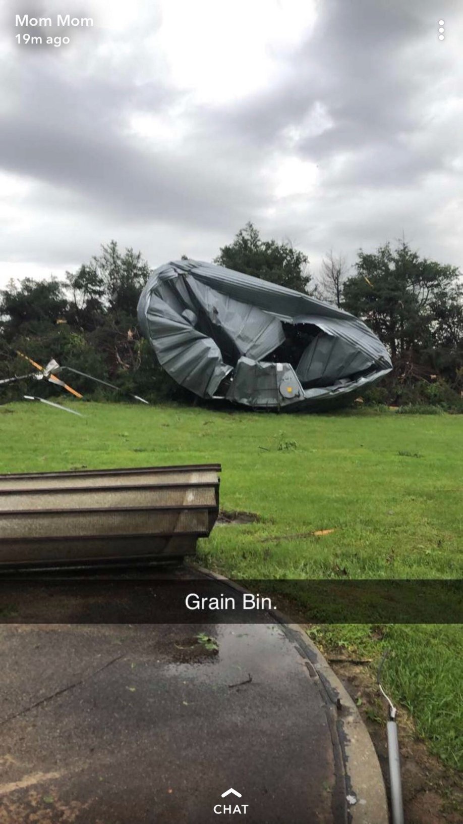
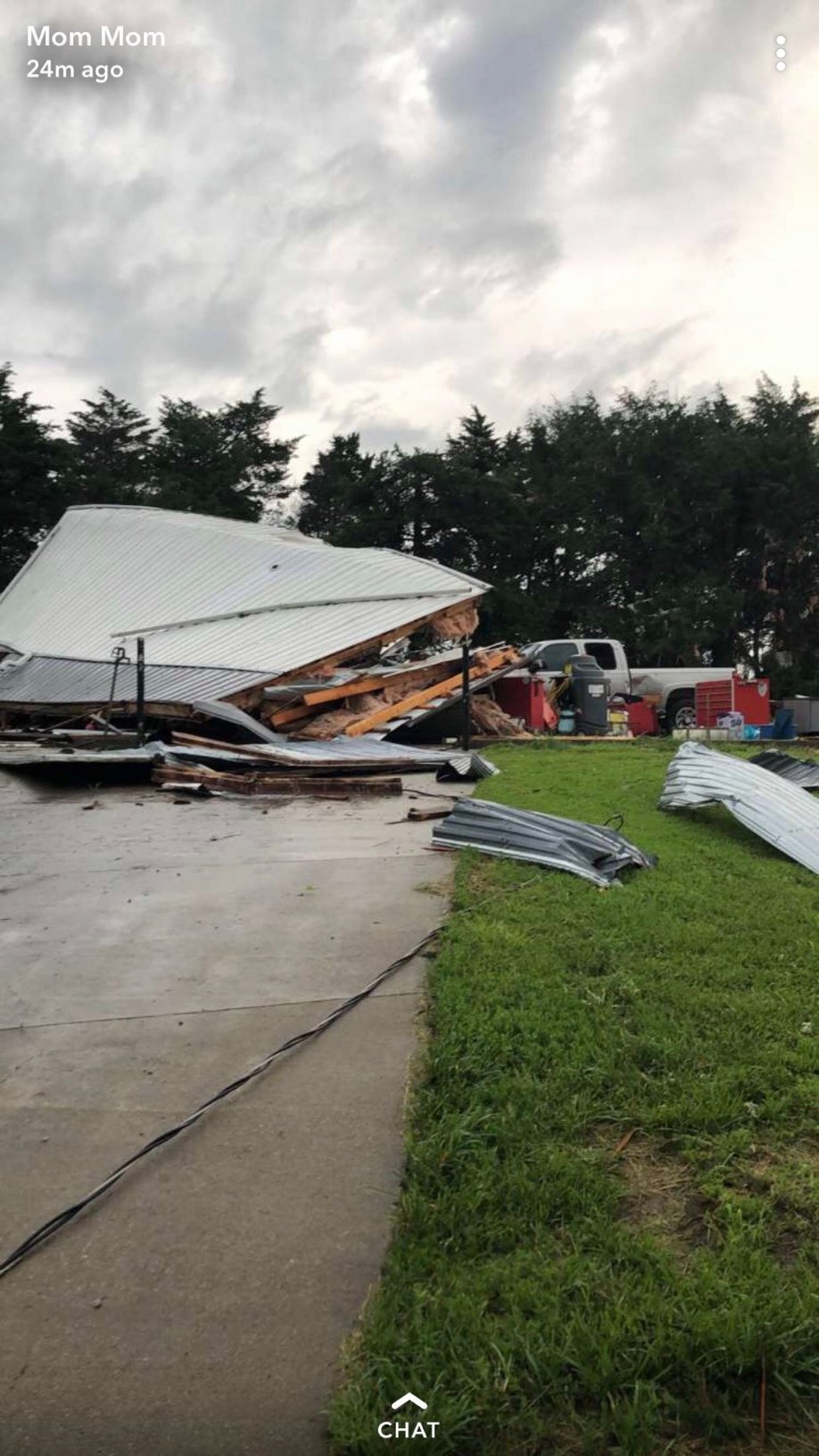
A tornado hit my uncle's place north of Seneca, KS this morning around 4:30 AM. Destroyed his mechanic shop and grain bin. The house seems OK thankfully.


-
There's two supercells northeast of Tulsa... near Vera and also Bushyhead that are starting to tighten up.
*Edit - There may be too much surging from the hook region for these to really get going.
-
3 minutes ago, Calderon said:
Starting to notice a majority of the storms, IL all the way to OK of gusting out becoming the dominant appearance, the lone exception in SW MO. I'm not dismissing the threats, but it seems like we've peaked and on the downtrend overall.
Agreed. Nothing significant it seems on radar. There's a fairly small but tight couplet west of Vera, OK but most others are pretty broad. Hopefully the trend continues.
*Edit - That Vera, OK circulation had an interesting NNW track...
-
1 minute ago, RandomBlue said:
So.. has that wedge tornado from Joplin been on the ground for 2 hours now?
Just now, janetjanet998 said:everything is slow to load today for me..hard to keep track...but didn't it cycle a few times?
It has cycled numerous times so it's not one continuous tornado... but many separate tornadoes. Not clear if it's had something on the ground continuously.
-
There's three tornado warned supercells in a row in Illinois, with the lead storm on a track towards Peoria.
-
Trailing Missouri supercell looks like it will need to be tornado warned soon, just north of... you guessed it... Golden City.
*Edit - Tornado Warning now. Rotation a few miles north of Golden City.
-
1 minute ago, JMT417 said:
Let’s all come to a agreement which thread we will be posting to for today’s event instead of having to check 2 threads
I'd say this is a big enough stand-alone event to use the other thread dedicated for today. If y'all could post there that would be good IMO.
-
26 tornado reports yesterday.... 37 reports today.
Seems like the best days are usually surprises more often than not lately.
-
1
-
-
2 minutes ago, cheese007 said:
Warning out for a "large and extremely dangerous tornado" in Coleman county TX
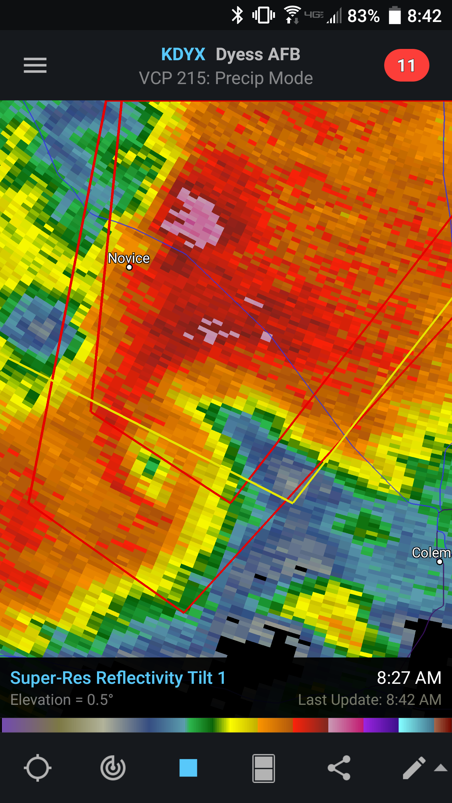
I don't think I've ever seen a precipitation hole as pronounced as this with a tornado. Wow!
-
The new Day 1 Outlook has extended the Enhanced area and 10% hatched tornado area significantly westward, now encompassing most of north and northeast TX, SE OK, NW LA, and a large portion of AR.

-
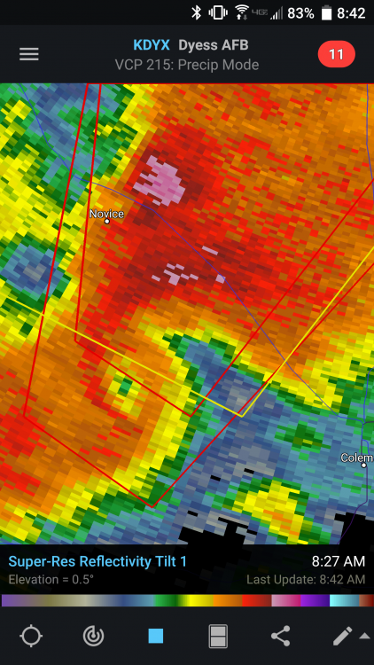
That Ballinger storm is still looking nasty heading towards Novice, TX. I didn't expect to wake up to conditions that look like this already...
-
7 minutes ago, aggiegeog said:
Man this afternoon was intense in E TX. The most widespread damage seems to be in Longview. Area wide though many roads and schools are closed.
Yeah, the storms were pretty blah right up until around 2 pm as they approached the 259 corridor in NE TX then all of the sudden there were QLCS spin-ups everywhere. I was on my way back to the office and watched it spin up hard from the north loop in town. If there was a tornado in there at least it was fairly weak, it was rain wrapped so I couldn't see anything else. Mostly tree damage although the steeple off of a church in town was blown over... And a Sonic sign was damaged.


Texas/New Mexico/Louisiana/Mexico Obs And Discussion Thread Part 8
in Central/Western States
Posted
Doesn't look promising. I guess I'll have to keep watering my lawn!