

cstrunk
-
Posts
574 -
Joined
-
Last visited
Content Type
Profiles
Blogs
Forums
American Weather
Media Demo
Store
Gallery
Posts posted by cstrunk
-
-
We only have ended up with sprinkles the last couple of days, but finally managed to get about 0.5" or so with a nice shield of rain showers/embedded thunderstorms this morning.
Maybe I can get greedy with another round this evening... We'll see!
-
Finally able to "cash in" on about 0.3" or so this morning. Not much but it helps. Dry weather for the rest of the week is in my forecast.
-
We have returned to basically completely dry weather conditions for the foreseeable future in East TX. Highs are reaching the upper 90's with low-mid 100's forecast by the end of this week. 104F on Friday and Saturday. Hot hot hot!
-
Moderate to occasionally heavy downpours have been frequent across the area for the past week or so. Well, frequent everywhere but IMBY, as they're still too scattered in nature. Just can't catch a break.
NWS Shreveport mentions a NW-flow pattern setting up by mid-week next week that may bring some organized convection into the region overnight into early morning hours. I sure hope that pans out better than the spitting match mother nature is currently competing in around here.
-
A TUTT is moving west along the gulf coast, which is expected to provide increased rain chances over the next week. WPC currently has my location at about 1-1.25" over the next 7 days, with 4-5" possible farther south over the LA/TX coastal areas. Crossing my fingers.
-
On 6/20/2018 at 10:02 PM, cheese007 said:
Feels like there's an inverse relationship between severe storm liklihood and SPC risk level for the DFW metro this season
I think the same is true for many areas this season.
-
On 6/18/2018 at 8:47 AM, cstrunk said:
Seems like I've had about 1" of rain total over the last couple of months. The tropical low is finally making its way towards Texas, and will help provide increased rain chances this week. WPC says 1.5" or so for this week... I'd be happy with 0.5" at this point.
Well, I guess something is better than nothing, but this has been very disappointing with such a tropical airmass in place. I keep consistently missing out on heavier showers/thunderstorms IMBY. Today was pegged as "the day" for rainfall and I may have received 0.20", tops. Maybe I'll get lucky and there'll be a rogue overnight storm with the weak frontal passage.
-
Seems like I've had about 1" of rain total over the last couple of months. The tropical low is finally making its way towards Texas, and will help provide increased rain chances this week. WPC says 1.5" or so for this week... I'd be happy with 0.5" at this point.
-
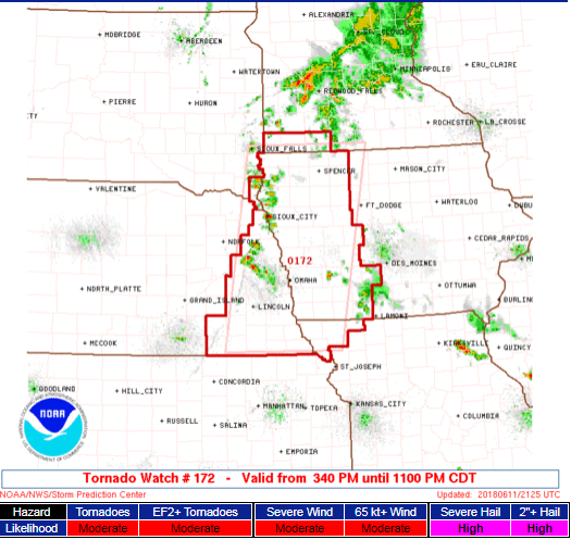
Tornado watch issued, mentions 3" hail and a couple intense tornadoes possible.
-
Missed out on all the storms late last week and over the weekend. Small chances throughout this week, but I'm keeping an eye on the tropics, hopefully this next system can stay far enough west to give Texas some good widespread rain next weekend/week.
-
Looks like my rain dance worked. Missed the heavier downpours IMBY but still probably ended up with 0.4" or so.
-
Just a few sprinkles so far IMBY. Clouds for most of the day from the MCS that fell apart to the west did a decent job of holding down temps. There's a few severe thunderstorms in the area but they're mostly just to my south. If I'm lucky I might get grazed by a shower and pick up 0.05" or so. I'm still holding out hope for more development overnight into tomorrow. I guess I better start my rain dance.
-
-
Shreveport NWS discussion this morning notes that the early heat is reminiscent of summer 2011, although that winter/spring was much drier than this year.
-
It's definitely been a pretty boring stretch of weather the last month or so (or more?). At least this week there's been slight chances of afternoon thunderstorms, but I can't seem to cash in on one. NWS has a 50% chance for today so we'll see, I'm not holding my breath.
Other than a PDS tornado watch earlier this year (that didn't pan out), and a soggy February, I've been pretty underwhelmed by this spring.
-
What an awful severe weather season. "There's always next year..."
-
I had to scrape the frost off of my windshield this morning. That's crazy for mid-April.
-
Had a nice storm blow through last night, and apparently produce a tornado just a few miles away near Diana, TX.
-
We have a day 2 enhanced risk for a decent chunk of the mid-south for a strong to severe MCS expected to move through the region. Hail, wind, and isolated tornadoes in spin-ups along the line look possible.
-
4 hours ago, cstrunk said:
I'm a couple hours east of you, but I'm not thrilled with the HRRR/NAM for my prospects. The storms in central TX look to move south of my location robbing energy for storms that develop along the cold front and move southeastward towards me. The storms on the cold front seem to die as they reach my area. We'll see. It is very windy and warm outside, partly sunny.
Well, the models pretty much nailed this to a "T" for my location. The heavier convection stayed just to my south, and the storms that fired along the cold front fizzled out pretty quickly. Pretty amazing job on their part.
-
5 minutes ago, cheese007 said:
Wasn't expecting the severe watch for the metro
I'm a couple hours east of you, but I'm not thrilled with the HRRR/NAM for my prospects. The storms in central TX look to move south of my location robbing energy for storms that develop along the cold front and move southeastward towards me. The storms on the cold front seem to die as they reach my area. We'll see. It is very windy and warm outside, partly sunny.
-
It's looking like a very stormy/rainy mid week for much of East TX, southern AR, southeast OK, into much of LA. Large hail/wind seems to be the main severe threat coupled with widespread 2"-6" rainfall totals.
-
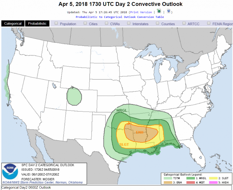
SPC has added 15% probabilities for severe in their latest Day 4 outlook (Friday, March 16th) for all of Arkansas into southern Missouri and the Arklatex region.
That's the first day of our camping trip. I love storms, but could do without them for camping, especially in an area that is saturated with tall trees.
-
On 3/11/2018 at 1:57 AM, cstrunk said:
A few severe thunderstorms over NE TX tonight. I hope we cash in on a nice shower for my lawn!
There ended up being quite a few severe thunderstorm warnings late Saturday night into Sunday morning. There were a number of hail and wind reports (up to 80-90 mph). One of the hardest hit areas was over Lake O' The Pines, where a bunch of trees blew over. *Edit - There was unfortunately one fatality and several others injured at the Brushy Creek campground. Another fatality and injury was reported in Longview when a tree fell on a their house.
I ended up with a nice lightning show and almost an inch of rain in my backyard. We're going camping in Arkansas this weekend, hope the weather cooperates...
Texas/New Mexico/Louisiana/Mexico Obs And Discussion Thread Part 8
in Central/Western States
Posted
I ended up with around 0.75" over the weekend. Picked up a little more on Sunday, we definitely needed it.
One of these days I'm going to invest in a personal weather station...