

cstrunk
-
Posts
592 -
Joined
-
Last visited
Content Type
Profiles
Blogs
Forums
American Weather
Media Demo
Store
Gallery
Posts posted by cstrunk
-
-
West Texas has certainly been active this week. It's been nice to see areas that need rain get it. Would like to see our friends in south/southwest Texas get in on more of it.
Monday looks like an interesting day in the central plains, with severe threat progressing south/east through the week.
-
16 hours ago, mob1 said:
On Google Maps it seems that most of houses are on the southern side of town so hopefully it missed them to the north (though it's hard to tell).
Luckily it did miss town to the north. Undoubtedly a few farmsteads were probably hit. Haven't really seen or heard of much damage though - yet.
-
Pretty strong wind with very heavy rain with the line that moved through Longview this morning.
My boss's shed landed in my backyard. Fences are fine so it went airborne.
-
 1
1
-
-
That Day 1 upgrade for tornado probabilities is concerning for NTX and S/C OK since it will be a late night/early morning threat. Hopefully storm mode stays messy and it doesn't get out of hand.
-
Tuesday is definitely on my radar for threat to my local (ETX) area, but the highest threat seems to be into AR and LA at this time.
BTW - The dates should be 3/4 and 3/5.
-
 1
1
-
-
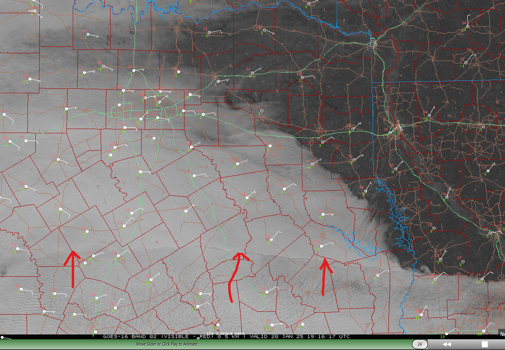
Interesting satellite imagery... can someone explain what this feature is that is rapidly expanding north? Seems like some kind of mid-layer moisture (causing clouds) advecting northward? -
06z GFS has the storm on Tuesday the 21st now. 18" of snow in deep ETX.

-
1
-
-
42 minutes ago, aggiegeog said:
31F with freezing rain and sleet here now
Around 5:30 pm we dropped to 31.8F and stayed there until a little while ago, rose to 32.2F. About the worst possible winter weather situation.

-
25 minutes ago, aggiegeog said:
At this point over here I dont think we overcome the warmth to switch to accumulating snow. The joys of winter in TX, maybe some light snow showers in the morning.
Agree. WAA/warm nose wins.
-
1
-
-
Might be something around/after New Year's Day... according to GFS.
-
Changes coming later next week, it seems. Just in time for my wedding weekend.
-
1
-
-
13 minutes ago, Ed, snow and hurricane fan said:
Generic non-severe thunderstorm killed power here for about 20 minutes. I've lived in Austin, DFW area, Midland, Monahans and here, and noplace but here is it routine for the lights to go out during a non-severe storm.
Pretty common in Longview. Too many trees next to above ground electric lines.
-
1
-
-
23 hours ago, canderson said:
No damage for you I hope?
Luckily, none for me!
-
1
-
-
12 hours ago, canderson said:
Parents have a 6.5” rain gauge. It overflowed an hour ago and it’s still raining over them in East Texas. Can’t reminder a storm hitting the gulf that caused so many problems in NE TX.
I ended up with 1" on Sunday and 5.25" yesterday on the north side of Longview. The tornado warnings yesterday were something else.
-
1
-
-
At my house, I got 1.00" of rain on Sunday, and 5.25" yesterday from Beryl. Yesterday was pretty wild with all of the tornado warnings in E TX and NW LA. Winds were a little gusty at times yesterday afternoon, but thankfully we only lost power once for about 20 seconds and that was all.
-
Keeping an eye on Beryl...
-
I'm on day 8 in a row with measurable rainfall, with several multi-inch events within this span. Tomorrow morning will likely be day 9.
-
Another MCS moving through NE Texas.
Another one likely later tonight/tomorrow morning.
-
1 hour ago, canderson said:
Parents have given up. They’ve had 9 severe t-storm warnings (and 2 tor warnings) in 6 consecutive days. And more than 8” rain.
Yeah it's been quite the stretch here. Don't think we're done yet either.
-
It's mid-afternoon, there's a MCS diving SE from Oklahoma into huge CAPE (4000-6000 J/kg), mid-upper 70's dew points, adequate bulk shear (35-40 knots), 100-200 m2/s2 helicity, and yet it's not severe. What's holding it back?
-
14 hours ago, Chinook said:
>150mph delta-v with this strong tornado
Yeah that was a nasty storm in West Texas. My post was focused on my area in East Texas, I should have been more clear.
We ended up with 3.27" of rain yesterday. Just a bit of light rain this morning, 0.12" so far and I don't expect much more.
I'm looking forward to some drier weather, I need to mow my lawn!
-
Well there were a few rotating storms along I-20 in East Texas this afternoon but nothing tightened up. There was one tornado warning near Marshall, TX.
Now the focus is very heavy rain. A very large flash flood warning has been issued along those same areas of I-20 for this area. Not much lightning and thunder.-
1
-
-
59 minutes ago, Chinook said:
Yesterday was a weird day with a couple of rounds of severe weather for South Texas. The first round was much earlier in the afternoon or morning. The enhanced risk seems to have been pretty good.
The enhanced risk was pretty good, but the slight risk extending up towards Texarkana was a bust. Models never really showed much north of I-10 in TX and LA, due to the substantial convection across S/SE TX and S LA... and that's what happened. Marginal risk for the northern uncertainty would have sufficed (and still not verify). -
I-10 special today from San Antonio through Houston later mostly for wind/very large hail.
Ended up with 1.49" yesterday.
-
1
-


June 8 Southern Plains Severe Outbreak
in Central/Western States
Posted
Pretty bow echo in ETX has more bark than bite. Warned for 80 mph and the tornado sirens sounded in Longview. Don't think wind even hit 40 mph.