

cstrunk
-
Posts
568 -
Joined
-
Last visited
Content Type
Profiles
Blogs
Forums
American Weather
Media Demo
Store
Gallery
Posts posted by cstrunk
-
-
I've had rain 8 out of the first 10 days in July so far. About 3" total. Continuing with a wet summer in this area so far, which has been nice. My lawn is loving it. Hope we can avoid any long dry spells before fall.
-
2 hours ago, Chinook said:
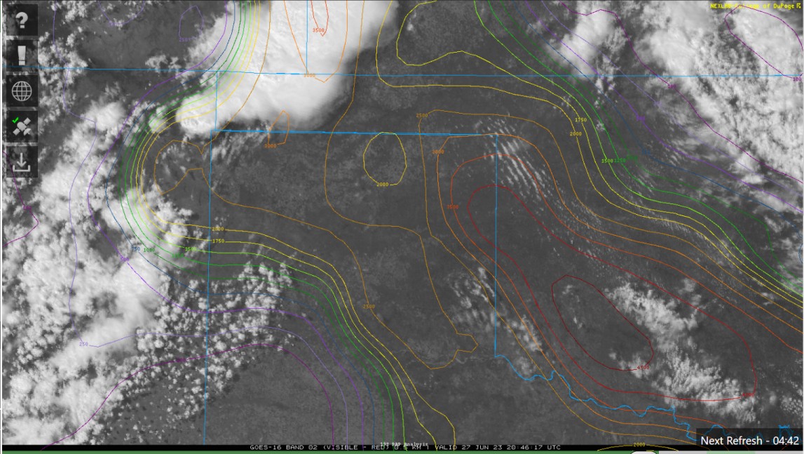
Here's a thing I don't use very much. COD satellite zoom-in with overlay of analysis (CAPE in this case). New storms approaching 3000 J/kg

I just discovered that feature myself within the last couple of weeks. Really sweet. You can set the overlays how you want and bookmark the page and return to it quickly. -
My weather station in Longview is reading a temp of 92F, DP of 81F (!), and heat index of 112F. It might be a degree or so high on the dewpoint but that's pretty crazy. You usually don't see that kind of dewpoint unless you're in the middle of an Iowa cornfield in July during a hot/wet year.
-
 1
1
-
-
30 minutes ago, Quincy said:
When you get the jet so far south in June… is when you get a northerly wind on the “cool” side of an outflow boundary with 5000+ CAPE and mid-70s dews. (DFW area)
Towers are attempting to go up near that boundary. Will be interesting to see if any updrafts can become sustained, given the conditionally volatile environment.
It seems that two have so far. Both severe warned. Ping pongs and quarters.
-
The last half of May was pretty dry in my neck of the woods. I've been thankful for almost 7" rain over the last 10 days. Still could get some more through tomorrow. That will help get through the upcoming heat wave - provided the rain doesn't completely shut off for a prolonged period of time.
-
1
-
-
1 hour ago, cheese007 said:
Looks like another south of the metro special up for today
It's not quite up yet, but new MD for the DFW area... watch possible.
-
1
-
-
The left splitter over the DFW metro verified.
-
3
-
-
It's been two weeks since it has rained at my house. We've missed all of the stray showers and storms. Hit or mostly miss showers/storms will be around again today and maybe tomorrow before shutting off again until this weekend.
-
 1
1
-
-
6 minutes ago, weatherextreme said:
Very green hail core headed that way.
-
Reflectivity looks like it's trying to form an eye... like a hurricane...
-
Just now, weatherextreme said:
Think it was mentioned from Reeds stream that they have a rain wrapped Tornado or wall cloud
Bob Pack said he may have caught a glimpse of it but it's definitely rain wrapped. Strong couplet with a CC drop beginning to show up. Likely TOG.
-
Today looks to me like a south of DFW I-35 hail special.
-
1
-
-
They ought to just stick to the EF-5 description for ratings and if they want to apply super-strict construction engineering criteria, reserve that for a new EF-6 category. That'll cause a stir.

-
Do we want to rename this thread? Or start a new thread for 2023?
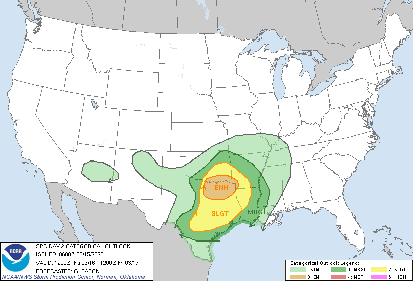
SPC highlighted much of eastern OK, NC TX, and eastern KS in their Day 4 (Friday) Outlook for severe weather will all hazards possible.
-
13 hours ago, mayjawintastawm said:
I'd love to get more than 0.1" moisture in any form. Something is persistently keeping this from happening east of the Divide and south of Wyoming for about 500 miles.
The Rocky Mountains?

Sorry, couldn't resist.
-
2
-
-
4 hours ago, Ed, snow and hurricane fan said:
The Arkansas part of the Moderate Risk never quite overcame the cap. Those storms would have had plenty of instability and vorticity. I'm sure the people of Arkansas don't mind. They've had enough of a tornado season to fill up a year.
Seems like the cap and the moisture mixing out really prevented yesterday/last night from being a LOT worse than it turned out to be.
-
1
-
-
Central Iowa looks to have a rough go of it late this afternoon/early evening...
-
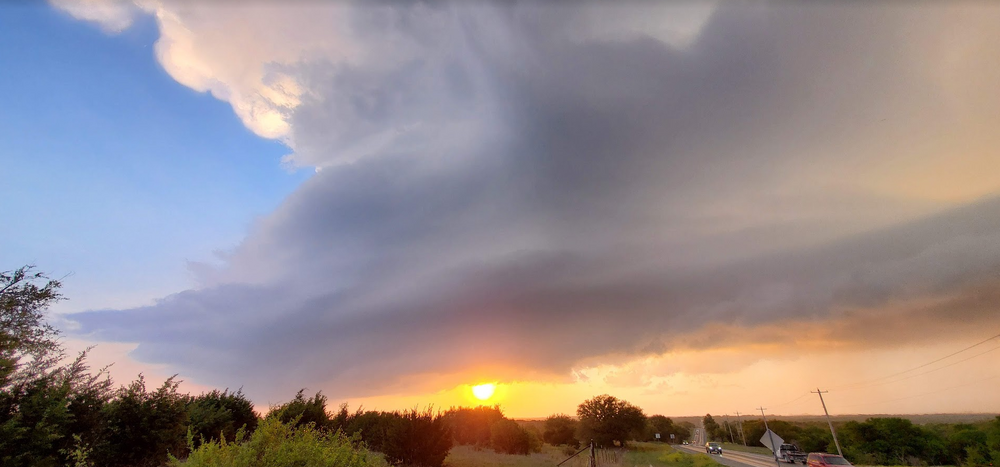
I chased the Stephenville, TX supercell - what a beautiful storm. No tornado. I'll get some pictures posted when I get a chance.
*Edit - here's a sneak peak:
-
1
-
-
Made it to Glen Rose. Headed west towards that cell SE of Abilene. Sun is out, it's hazy, and the wind is howling.
-
2
-
-
2 hours ago, cstrunk said:
I'm thinking about chasing today for the first time in forever. My target would be Glen Rose.
Pulled the trigger. In Terrell now, still headed in the direction of Glen Rose. Hope to follow any supercells to the south of the Metroplex.
-
2
-
-
I'm thinking about chasing today for the first time in forever. My target would be Glen Rose.
-
If I were chasing today I'd be just south of Lawton, OK and follow storms east on the north side of the Red River. Denton, TX wouldn't be a bad place to start either.
-
1
-
-
SPC adds an enhanced risk area for NC/NE TX and extreme SE OK.
-
1
-
-
Confirmed tornado warning for Bossier City, LA.

Texas/Oklahoma 2023 Obs and Discussion
in Central/Western States
Posted
Made it to 101F in Longview yesterday. My weather station shows a 77F dewpoint also and a 118F heat index. The airport south of town recorded 101F but a slightly lower dewpoint at that time (72F) which corresponds to a 112F heat index.
SHV didn't pull the trigger on an excessive heat warning yesterday, but did for today and tomorrow. The dewpoints just aren't mixing out as much as expected.