

cstrunk
-
Posts
568 -
Joined
-
Last visited
Content Type
Profiles
Blogs
Forums
American Weather
Media Demo
Store
Gallery
Posts posted by cstrunk
-
-
2 minutes ago, STxVortex said:
Looking at AF 302 and 303's last reported positions I guess that I'll go outside in about 30 minutes and look for them overhead on approach to Kelly. And listen too, maybe 302 lost an engine...
Well, losing a engine would certainly be a good reason to not fly into a Cat 4 'cane. But what are we doing? Flying WW2 planes into hurricanes? It's 2021 for crying out loud. This program needs more funding.
-
 10
10
-
-
This has been a great summer so far. Most days in the 80's or low-90's and above normal precipitation. I haven't had to water my lawn once this year.
-
I had 0.39" on Monday and 0.3" the previous Monday. I'll take that for late June but hope that continues through the next couple of months. It still looks good for the next few weeks at least.
-
Quite a bit of sunshine today, a humid airmass, and relatively strong low level winds make today seem like a stronger risk for severe weather this afternoon in East Texas than many other days that have been cloudy/less windy.
-
7.78" of rain measured at my house in a 22 hour period from 9:30 pm Monday night through 7:30 pm Tuesday night.
-
These training storms are making it awfully hard for me to get back home... (Flight to DFW and then GGG, the latter of which has already been cancelled).
-
 3
3
-
-
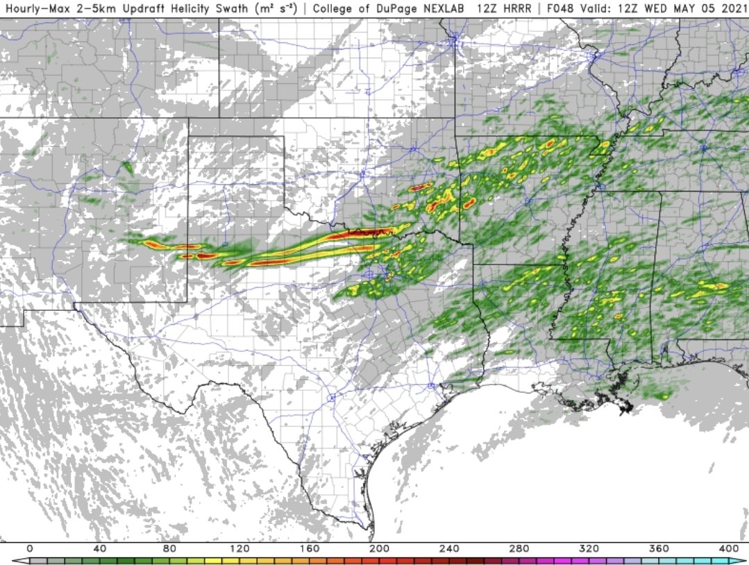
Holy 12z HRRR helicity swaths for NW/northern TX this afternoon...

-
 1
1
-
-
That's just Reed doing Reed things. He acts that way for three reasons. 1) He has an insane passion for severe weather. 2) He knows that he can hype ANYTHING to generate more clicks, views, ratings, etc. which generates him money. 3) He has a screw loose in his head.

But whatever you say about him, the dude just gets it done more often than not.
-
1
-
2
-
-
Beautiful tornado warned supercell with very strong rotation just north of Guthrie, TX.
-
1 hour ago, Chinook said:
Enhanced risk for SE TX has completely busted unless there's somehow 80 severe weather reports after midnight

Messy storm mode in ETX killed the threat.
-
1
-
-
Big ol ETX bust is what I see.
-
Grunge-fest in progress along and east of I-35. We'll see how the activity reacts to the strengthening wind profiles into the evening.
-
The East Texas and Louisiana threat looks pretty dang messy and will be in questionable to poor chase terrain. The extreme NW Texas threat looks like a pretty good bet to at least see 2-3 isolated supercells. The tornado threat may be a tad bit lower but from a storm chasing perspective, that's where I would target.
-
3.76" of rain over the last week has been nice since models had been showing quite a bit less. Hopefully the rest of Texas is cashing in, or can sooner rather than later.
-
17 hours ago, jojo762 said:
General idea in mid/long-range guidance is that there could be a solid trough in the southern Plains next week... Not much agreement on timing or degree of moisture ATTM, but at least its something to watch?
There may also be some action in the central plains towards the last few days in April.
-
1
-
-
06z GFS is showing potential for the 4/23-4/28 timeframe.
-
1
-
-
I guess they decided that the Euro wasn't the model to follow after all (or maybe the Euro caved)? This update lines up with what the NAM and HRRR are showing.
-
Latest HRRR, NAM 3K NEST, and GFS don't seem to support the threat around DFW and southward. Mostly seems to develop a MCS in SE OK that bows southeast overnight.
-
1 hour ago, MattPetrulli said:
So if Friday continues to trend in the wrong direction (hopefully not an early morning severe wx outbreak), is this going to be the main thread or is a new thread gonna be made in the SE subforum?
Well, it still seems like there could be substantial severe weather in OK/TX/AR/LA. So this would be the place for that in my opinion.
-
Well today looks like an Enhanced Bust.
-
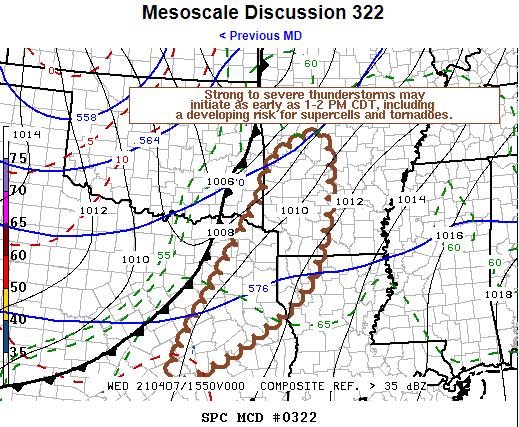
   Mesoscale Discussion 0322
   NWS Storm Prediction Center Norman OK
   1110 AM CDT Wed Apr 07 2021

   Areas affected...Parts of eastern/northeastern Texas through western
   Arkansas

   Concerning...Severe potential...Watch likely

   Valid 071610Z - 071815Z

   Probability of Watch Issuance...80 percent

   SUMMARY...The initiation of strong to severe thunderstorms appears
   possible as early 1-2 PM CDT.  This may, at least initially, include
   discrete supercells, before a squall line tends to evolve, and a
   risk for tornadoes, one or two of which could be strong.

   DISCUSSION...Cloud cover is slowing moist, warm sector
   boundary-layer destabilization, but it appears the air mass is
   already potentially moderately unstable as the significant upstream
   short wave trough begins to take on a neutral to negative tilt
   across the central Great Plains.  Downstream of the base of this
   troughing, beneath increasingly difluent mid/upper flow,
   considerable model output suggests that erosion of inhibition
   associated with capping elevated mixed-layer air, coupled with at
   least some further boundary-layer warming, will allow for the
   initiation of thunderstorm development as early as 18-19Z.
   Initially this may be largely discrete, and scattered, but focused
   within a zone of enhanced low-level convergence along an eastward
   advancing cold front.

   With the environment becoming characterized by wind profiles with
   strong deep-layer shear and sizable, clockwise-curved low-level
   hodographs, in the presence of a deep moist boundary-layer, it
   appears conducive to supercells capable of producing tornadoes.
   This includes potential for a strong tornado or two, though the
   overall tornado potential could be mitigated somewhat by relatively
   modest high-level flow and the tendency for upscale convective
   growth along the cold front through the afternoon.

   ..Kerr/Hart.. 04/07/2021

   ...Please see www.spc.noaa.gov for graphic product...

   ATTN...WFO...LZK...SHV...TSA...HGX...FWD...EWX...
-
The GFS is showing a much more active period than it has been for much of the southern plains over the next 3-10 days.
-
1
-
-
Very strong rotation on the tornado warned cell near Rusk, TX.
-
6 minutes ago, Ed, snow and hurricane fan said:
Anyone else hate new NWS public radar format?
Yes, it is unusable, IMO. Did they not test it out before making the switch?? Takes forever to load and is very glitchy.
-
2
-
3/17/2022, 3/21/2022 & 3/22/2022 Severe Weather, Major Tornado Damage in New Orleans
in Central/Western States
Posted
I'm in Longview. It'll probably be closer to midnight before the current group of storms gets here. Unless something goes severe ahead of it.