

cstrunk
-
Posts
568 -
Joined
-
Last visited
Content Type
Profiles
Blogs
Forums
American Weather
Media Demo
Store
Gallery
Posts posted by cstrunk
-
-
This originally looked like a threat farther east of this region, but it has shifted further into our area. Latest short term models show supercells developing in NETX and points northeast by around 2-4 pm. All hazards are included in the threat with some being significant.
-
Actually I think it occluded and a new small tornado formed over Fayetteville.
-
Yeah after a couple increases it looks weaker now...
-
Velocities increasing last scan.
-
Just now, SmokeEater said:
Ridiculous debris ball, it hit something....
Sent from my SM-G973U using Tapatalk
Bibb Correctional Facility and likely a bunch of mobile homes on the SW side of Brent.
It's on top of the airport now.
-
There are a lot of trailer homes where the tornado is currently.
-
Bibb Correctional Facility just south of Brent, AL looks like it will take a direct hit.
-
Rotation increasing near Watauga or just north of North Richland Hills... No warning yet.
-
Decent hook just north of downtown Fort Worth but not much on velocity yet - keep an eye out.
-
4 minutes ago, TexMexWx said:
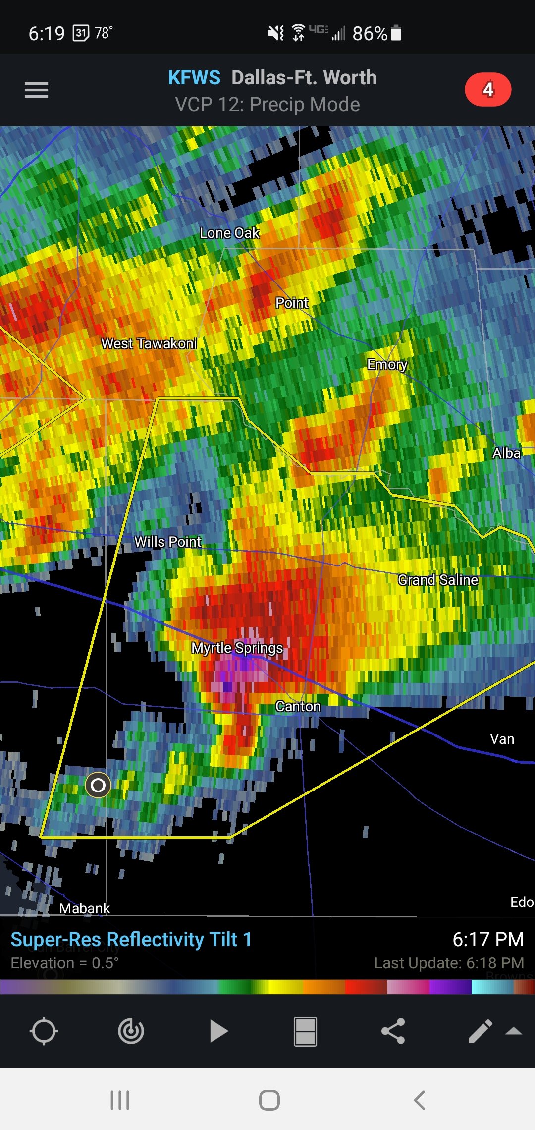
Tornado warning for Van Zandt county... north of Canton
Rotation still pretty broad. Still has a nasty hail core.
-
 1
1
-
-
-
1 minute ago, cheese007 said:
What's the threat looking like for western Dallas county? I have an event at 7 that might be impacted
In my unprofessional opinion, it's lower at this time. But there are some small cells in the DFW area and just south that are trying to form. Just not doing much yet. That may change so don't take my word for it.
-
Storms SE of Dallas are all taking on supercellular characteristics on radar. The Mabank storm has a really nice reflectivity presentation already... the others storms have "the look" as well. Large hail threat for sure on the east side of Dallas towards Lindale. Good shear in place but helicity values pretty modest, so the tornado threat will hopefully stay low, but may increase in time...
-
Storms are continuing the organize SE of Dallas. This is where the HRRR was spitting out some helicity tracks for the 5-7 pm range.
-
18 minutes ago, cheese007 said:
Huh was not expecting a Tor watch tbh. Any possibility it gets extended northward?
I thought the watch would have been issued sooner, but they were probably debating whether it should be a SVR or TOR. It seems to me like the 30/10 TOR is appropriate, based on the short-term guidance.
-
2 minutes ago, cheese007 said:
Starting to get some clouds going up in DFW. Looks like it's about showtime
Yeah, returns beginning to strengthen, especially SE towards Corsicana and Athens. Looks like it's along the warm front.
-
Reflectivity image is pretty crazy.
-
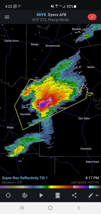
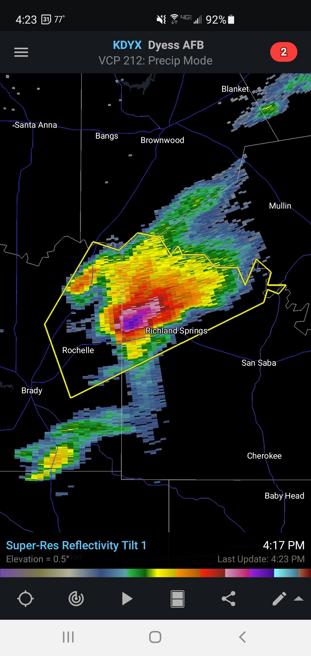
Looks like convection has initiated. Already a SVR for NE McCulloch and NW San Saba counties in central TX. Should see a watch issued soon.
-
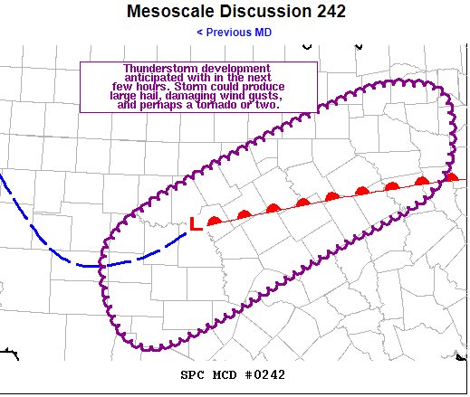
   Mesoscale Discussion 0242
   NWS Storm Prediction Center Norman OK
   0322 PM CDT Wed Mar 24 2021

   Areas affected...Central/North-Central TX

   Concerning...Severe potential...Watch likely

   Valid 242022Z - 242245Z

   Probability of Watch Issuance...80 percent

   SUMMARY...Thunderstorm development is anticipated this evening
   across western portions of central and north-central TX. Threat for
   large hail, damaging wind gusts, and perhaps a tornado or two will
   accompany this storms as they move northeastward into more of
   central and north-central TX. Trends are being monitored for
   possible watch issuance.

   DISCUSSION...Recent surface analysis places a weak low just
   southeast of BWD in central TX. A warm front extends eastward from
   this low, demarcated well by both the 56 deg F isodrosotherm and the
   edge of the cloud shield in visible satellite imagery. A surface
   trough also extends southwestward from this low before arcing back
   northwestward south of SJT into the TX Permian Basin.

   The air mass south of the warm front also continues to destabilize,
   particularly over the TX Hill County in the vicinity of the low.
   Recent mesoanalysis suggests MLCAPE around 500 J/kg near the low,
   increasing to over 1000 J/kg over in the region between Del Rio and
   San Antonio. Continued destabilization is expected as the warm front
   continue to move northward.

   At the same time, persistent low-level convergence in the vicinity
   of the low and its associated surface trough is expected to result
   in eventual convective initiation. Visible satellite imagery has
   shown several attempts at deep convection, although none have
   succeeded thus far. Current attempt is underway over McCulloch
   County. In addition to this mesoscale forcing, large-scale forcing
   for ascent is gradually increasing across the region as a shortwave
   trough approaches from the west.

   Once convective initiation is realized, the environment is favorable
   for maturation into supercells. Primary hazard throughout the
   evening will be large hail while some damaging downburst winds are
   also possible. Gradually strengthening low-level could also result
   in a tornado or two.

   ..Mosier/Hart.. 03/24/2021

   ...Please see www.spc.noaa.gov for graphic product...

   ATTN...WFO...SHV...FWD...EWX...SJT...
-
Yesterday was a debatable, but today looks like a glorified bust.
-
5
-
-
36 minutes ago, A777 said:
That looks much more like a shelf cloud with straight line winds moving overhead.
-
2
-
-
Seen this act before. This afternoon was definitely very active, but the large amount of rain in the risk area combined with a large maturing MCS moving through is going to mitigate the risk this evening and overnight.
NOT that there won't be a few more tornadoes, and possibly significant at that, but the risk level has definitely decreased.
-
1
-
-
32 minutes ago, TexMexWx said:
I've read it a couple of times on twitter... is it true that more pipes might burst when the weather actually warms up? I've already had at least three friends with pipe bursts in their homes, and I'm afraid that my luck will run out at some point. I hope all of y'all are still able to be warm and safe. Obviously, problems are pretty widespread throughout the state (power, water, etc.), but I've heard a lot of bad things going on with Austin's infrastructure. They've had multiple major ice events in addition to their snow.
Well, it's likely there are burst pipes that are still frozen and the leak won't be known until the ice thaws.
There's still brutal cold in the area and there will continue to be more frozen pipes through the next few days.
-
1
-
-
12 minutes ago, aggiegeog said:
Barely anything since early morning in Hideaway. Back edge has ease ever so slowly east. The Central Texas batch may get us. Not sure on precip type with that but I assume sleet.
On the DFW radar, new precip seems to be developing SW of Tyler. You may get in on some of that action. Doesn't seem too heavy yet, but may become so as it heads NE. Looks to keep me in some precip for a while this afternoon, yet. Probably sleet.
-
1
-

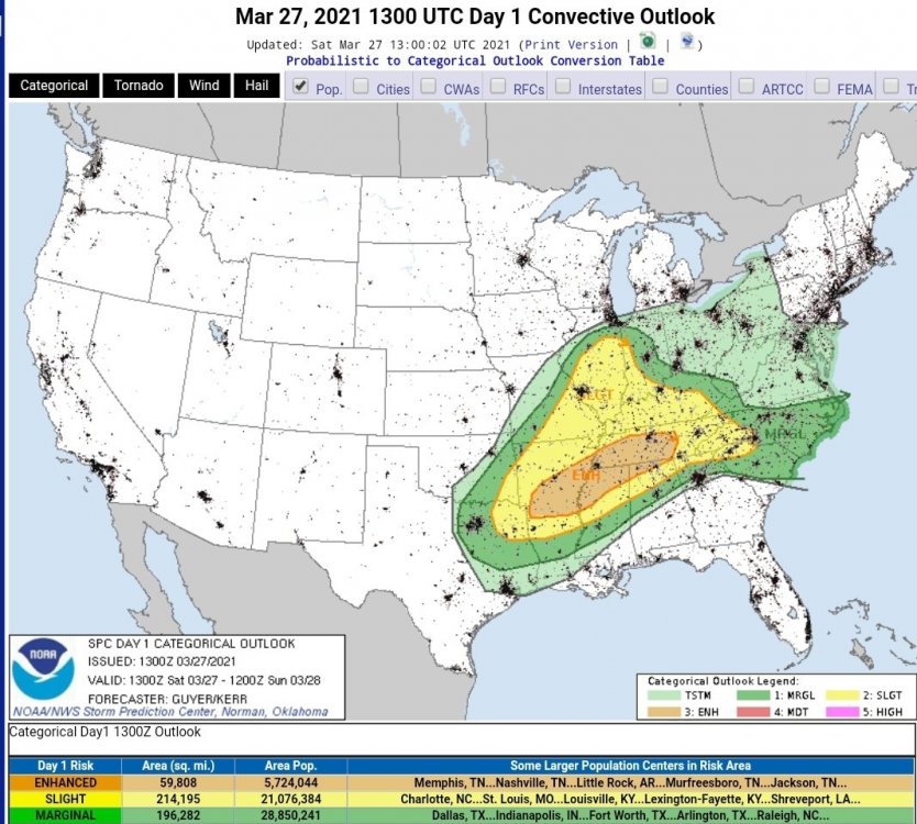
Severe Weather Threat 3/27/21 - NETX/LA/AR
in Central/Western States
Posted
Tornado watch issued. 70/60 probs...