

cstrunk
-
Posts
574 -
Joined
-
Last visited
Content Type
Profiles
Blogs
Forums
American Weather
Media Demo
Store
Gallery
Posts posted by cstrunk
-
-
If I were chasing today, I'd be targeting SE Nebraska in the Seward area and adjust as needed from there.
A secondary target would be central Kansas, in the Great Bend to Salina region. Both the NAM and HRRR develop what looks like a nice supercell in the same area, as a tail-end Charlie.
-
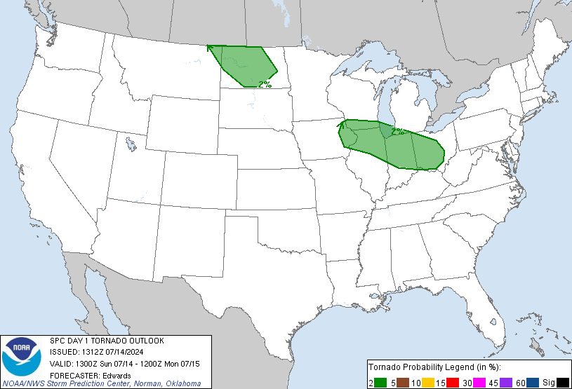
SPC has an enhanced risk across much of Iowa with a 10% tornado area in western/central Iowa.
-
The Chester, OK storm has a southward storm motion to it, while the Oakwood storm isn't moving much (slightly north?). How cool would it be to be sitting somewhere in between the two storms and see a distant tornado on each?
In fact, it would be interesting to hear if anyone knows of such an occurrence, where you are able to see more than one storm from the same location, each with a tornado visible. I've had dreams/nightmares of it happening, LOL. And no, I'm not talking about multiple tornadoes/wall clouds/areas of rotation on one storm, I'm talking about completely separate cells.
-
Daniel Shaw is streaming the storm. Someone else was radioing in some dust swirls as a tornado. In any case, there may have been a small funnel and there was definitely no condensation to the ground.
-
Decent looking supercell with a tornado warning just south of Kilgore, TX. Radar indicated at this time. Local news has reports of some wind damage in Arp, TX and a spotter has reported a well defined wall cloud and possible funnel just south of Kilgore.
-
The storm between Fort Worth and Hillsboro looks a bit ominous on radar.
-
This thread sure has been quiet lately.
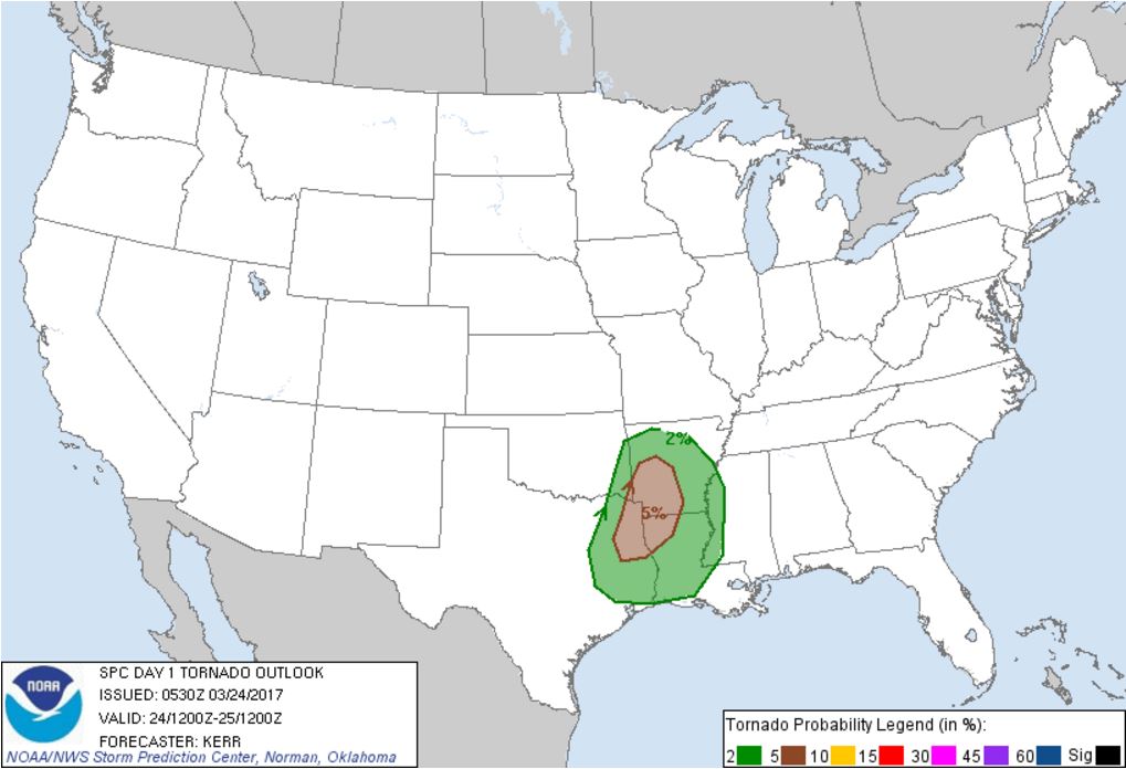
SPC has put the Ark-La-Tex region in a 5% tornado probability for later this afternoon (the 24th)...

-
It felt like early May outside today. High of 87. Tomorrow will be very similar, high of 85.
I'm hoping we can get some decent storms out of this system coming later this week.
-
15 minutes ago, Jim Martin said:
Incredible Three Body Scattered Spike on this supercell headed for Springfield.
Definitely looks like Springfield will miss the worst of the storm, with the main part diving hard right to their south.
And the storm is definitely winning the battle versus the weaker storms to the west.
-
That storm looks like it's rooted on the outflow boundary moving south. It will be interesting to see if it can clear itself of the storms to its west.
-
I tried a test-run of a GoPro time-lapse on my way to work this morning, thinking I might catch some good views with the front/storms moving through. I still have some things to figure out. Luckily, the views weren't that interesting, weather-wise. It was mostly light rain the whole way with a few heavy downpours here and there.
-
Well it looks like this afternoon was mostly a dud. One storm did get going fairly well around Lake Fork, with a severe warning tagged on it. But it never really looked that ominous except for maybe some hail. I was close to heading out the door to catch up with it before sunset, but decided not to. In hindsight I probably should have, I've been wanting to get more experience in shooting with my old GoPro that I haven't used much. The lack of low clouds in the area might have made for a nice show.
-
Looks like new storms are firing southeast of Dallas.
-
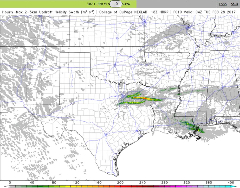
Keeping an eye out this afternoon. The 18z HRRR is hinting at a pretty substantial UD Helicity Swath sweeping through east Texas this afternoon/evening. Pretty much right along I-20 east of Dallas. I wonder if it is picking up on an outflow boundary being laid down by current storms in NE Texas, with later storms firing east/south of Dallas and latching on and riding it all the way to Shreveport?
I stepped outside around noon and the atmosphere definitely had that feel to it. The sun is shining and it is 78/64 in Tyler.

-
I was hoping for some lightning and thunder overnight... but alas, nothing. Just a steady cool rain. If we aren't going to have any more winter, I'd at least like to get the severe weather season rolling around here.
")
-
Looks like a really nice week upcoming for East Texas. Boring as far as precipitation goes, but we'll be close to a record high in Tyler on
Monday, February 6th. Forecast high is 83F and the record (1911) is 84F.*EDIT - Looks like the record high is for tomorrow, Tuesday, Feb 7th at 82F. The forecast high is 83F.
-
We ended up with 5.33" rainfall since this past weekend at my office.
-
At my office east of Longview, TX, we've had about 3.7" of rain measured in our rain gauge. The streams/creeks are just out of their banks. We may end up with a few more tenths to a half an inch today depending on if we get hit by any of the heavier cells that have yet to move through the area.
-
Finally seeing a couple flurries here and there in Tyler. Not going to get anything more than this it looks like. Congrats to you guys in DFW with the dusting.
-
7 minutes ago, Quixotic1 said:
I'm getting dry slotted! Haha
You're still sitting better than us in East TX! Wintry precip to our SE and NW... Nada here.
-
1 hour ago, jhamps10 said:
Had flakes when I was walking out the door in SW Arlington, drove through a decent sized burst on 20 near the East loop 820 merge.. NBC5 is saying that this is Lake Effect off of Lake Grapevine... Not sure I'm buying that but okay whatever.
Getting some light flurries now at my office in Downtown Ft Worth, hard to tell since I'm 33 stories up
34 minutes ago, aggiegeog said:I can buy the lake effect idea with NE winds off of the lakes and temps in the low 20s. Lake effect snow is not as rare as you would think when temps get this low with wind blowing decently around here.
The radar returns are lining up pretty well with Lake Ray Roberts, Lewisville Lake, and Grapevine Lake. Lake effect snow in DFW... who'da thunk it?
-
We all want storms/blizzards/interesting weather, that's why we are here in the first place. That doesn't mean we want to see it cause harm to anyone or their property.
But that is the nature of the weather and there's nothing we can do about it except raise awareness and track it.
-
SPC mentions that the front is trending slightly faster, so the severe risk is trending the wrong direction, towards the east. Bummer. Hope that changes.
-
I hope I did this right and it's not time-sensitive, but I'm glad to see a Day 5 slight risk for deep east Texas. I'd like to see the system slow down a bit and move a bit farther west, but at least there's some interesting non-winter weather possible in my neck of the woods for Saturday:
A cherry on the top would be a bit of wintry precip behind the front Sunday morning. At least we have something interesting to follow!
Texas/New Mexico/Louisiana/Mexico Obs And Discussion Thread Part 8
in Central/Western States
Posted
Boy, this thread sure has died.
An enhanced risk exists across SE OK and north-central to northeast TX this afternoon and evening with 5% tornado prob's.