

cstrunk
-
Posts
601 -
Joined
-
Last visited
About cstrunk

Recent Profile Visitors
3,976 profile views


-
My Father-in-Law is without power in Henderson. Since 12:30 am.
-
Not much freezing rain in north Longview from this event. Less than 0.1". 1.5"-2" sleet. QPF way underperformed. Pretty much all models had a 2"+ bullseye in NE TX. Isolated areas may have verified but I'm guessing precip was overdone for many areas.
-
Yep quiet afternoon. Sleet has returned. I feel like it'll all be sleet. Maybe some flakes at daybreak. Temps in the mid-20's.
-
Heavy sleet in Longview right now at 31F.
-
Storms in south Texas with the initial wave may rob some moisture somewhere in E/NE Texas. Something that may limit total precip from 1.5"-2" down to maybe 1" in some places.
-
I hope you are right and Longview gets 0.25" or less freezing rain. The ISW calls for 0.5"-0.75" with up to 1" of ice, but as aggiegeog noted, we seem to be dancing along a fine line.
-
Devastating ice storm potential for the general vicinity of the Arklatex and a bit south and east of there. Many models are showing fairly large areas of 1"+ of ice.
-
Decent severe weather threat for much of east Texas into LA/MS this afternoon into tonight. Could see a few sky noodles.
-
Yes. Similar events with dozens of deaths have occurred in the region - some recently. Flash flood awareness should be higher here. https://en.wikipedia.org/wiki/Flash_Flood_Alley
-

June 8 Southern Plains Severe Outbreak
cstrunk replied to Powerball's topic in Central/Western States
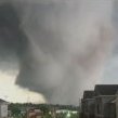
Pretty bow echo in ETX has more bark than bite. Warned for 80 mph and the tornado sirens sounded in Longview. Don't think wind even hit 40 mph. -
Plains States Observations and Discussion Thread
cstrunk replied to lookingnorth's topic in Central/Western States
West Texas has certainly been active this week. It's been nice to see areas that need rain get it. Would like to see our friends in south/southwest Texas get in on more of it. Monday looks like an interesting day in the central plains, with severe threat progressing south/east through the week. -
2025 Short Range Severe Weather Discussion
cstrunk replied to Chicago Storm's topic in Lakes/Ohio Valley
Luckily it did miss town to the north. Undoubtedly a few farmsteads were probably hit. Haven't really seen or heard of much damage though - yet. -
Pretty strong wind with very heavy rain with the line that moved through Longview this morning. My boss's shed landed in my backyard. Fences are fine so it went airborne.
-
That Day 1 upgrade for tornado probabilities is concerning for NTX and S/C OK since it will be a late night/early morning threat. Hopefully storm mode stays messy and it doesn't get out of hand.
-
Tuesday is definitely on my radar for threat to my local (ETX) area, but the highest threat seems to be into AR and LA at this time. BTW - The dates should be 3/4 and 3/5.


