

madwx
-
Posts
2,362 -
Joined
-
Last visited
Content Type
Profiles
Blogs
Forums
American Weather
Media Demo
Store
Gallery
Everything posted by madwx
-
we're less than 12 hours out and the NAM somehow is still showing me getting almost 8" by midnight.
-
I know I’m getting about 3” tonight but tomorrow could be 8” or 0” and i have no idea which way we’re headed
-
Down to -10 here. Likewise already up to 5
-

Winter 2024-25 Medium/Long Range Discussion
madwx replied to michsnowfreak's topic in Lakes/Ohio Valley
Feel pretty good about this so far, the storm track has been a bit further north than I expected but the cold will last through about the 23rd. Looking for mild air to flood the country after that though. -
most global keep showing crazy totals here. have doubts because the upper levels don't scream dynamic system to me and the snow comes in two crazy thumps of WAA and then frontogenesis well north of the main low pressure system
-
around 3" here, maybe a few tenths more tonight as the system winds down. the main defo band set up a bit to the south of model guidance so we were on the low end of totals
-
if you get enough forcing/upward motion to tap into the DGZ then you get really good rates, otherwise it's very blah. We'll get about 3-4 more hours of better forcing here through 7-8 PM, though we may end up just on the northern edge of things
-
ICON gives me 12.3" this weekend
-
Rates really plummet when we’re not in one of the bands. Even saw the sun peeking through the clouds for a bit
-
I know, just showing that the continuing pattern of the US being the cold outlier in the whole world
-
one of these areas is not like the others
-
flake size definitely improved over this transient band moving in from the southwest, should hit a lull though for the rest of the afternoon shortly
-
yes, something wrong with the data flow. https://x.com/CoDWXData/status/1889714294062776541
-
raods and sidewalks are covered now but the grass is still showing. definitely a bit of a north south gradient in the Madison area
-
why not, lets roll with the GFS on this one. 12" total with the WAA and then defo a day later
-
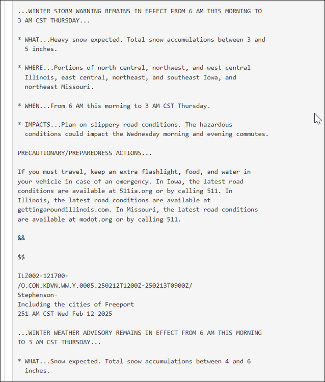
DVN had a pretty funny situation this morning, Winter Storm Warning for 3-5 inches while the Winter Weather Advisory was for 4-6 inches
-
Interesting evolution. We get hit with the lead shortwave/WAA on Friday and then are shut out the rest of the weekend
-
4.5” final call. Let’s stack some dendrites tomorrow
-
12z GFS holding serve with its more southerly path
-
Going to end with about a half inch here. Ground is mostly white
-
Winter 2024-25 Medium/Long Range Discussion
madwx replied to michsnowfreak's topic in Lakes/Ohio Valley
Update: they haven't posted a video today so not sure if they've considered adding 1899 as an analogue -
Have some blowing dust in the farm fields by my house. Pretty unusual for February
-
Winter 2024-25 Medium/Long Range Discussion
madwx replied to michsnowfreak's topic in Lakes/Ohio Valley
BAMwx says a mix of Feb 1985 and Feb 2021. Stay tuned! -
NAM and NAM3km always underdo temps in the winter and early spring. Especially in dry weather. They don’t mix the boundary layer enough and seem to overcompensate for snow cover too
-
Winter 2024-25 Medium/Long Range Discussion
madwx replied to michsnowfreak's topic in Lakes/Ohio Valley
starting to see some trends for the month of Feb. People who know more can expand and correct me. There will be some high latitude blocking that will give the Polar Vortex a jolt in about a week. Alongside a -AO/-NAO we will likely get a longwave trough in the E/C US. With increased warmth to the SE there will be storms tracking along the baroclinic zone which should give some chances of snow. The SE ridge will not be very strong though, so I wouldn't expect major storms tracking through our region. What will be likely though is below normal temps from about 2/10-2/24. At this time it's not guaranteed that we will have a SSW or have a split polar vortex, in fact there are signs that the disruption will be short lived and the PV will bounce back to strong levels. This means that the cold and blocking would not be favored to last into the month of March.


