

madwx
-
Posts
2,105 -
Joined
-
Last visited
Content Type
Profiles
Blogs
Forums
American Weather
Media Demo
Store
Gallery
Posts posted by madwx
-
-
16 minutes ago, CheeselandSkies said:
Not liking all these showers in the late morning.
these are elevated WAA showers so they aren't generating a cold pool. Surface warming already occurring in SW Wisconsin
-
 3
3
-
-
Pros: MCV barrelling down the Iowa/Minnesota border, should reach here during the afternoon, ample moisture return
Cons: All that convection between here and the MCV
-
 1
1
-
-
As long as there is no festering convection in eastern Iowa in the mid morning I’m feeling prettay prettay good
There's even some local backing of winds through late afternoon
-
1
-
-
1 hour ago, hawkeye_wx said:
The morning models have sped up the front and are now firing the storms farther south. The UK and Euro now have nothing here. The CAMs fire the storms just barely in time.
the HRRR has been trending slower all day and its been the quickest model. Hoping the trend continues so storms erupt in our area
-
1
-
-
day 2 of some fiesty thunderstorms about to hit MSN. Looking like some small hail and 40 mph winds expected with these. can hear the thunder get louder as it approaches
-
1
-
-
Friday looking more and more interesting for S Wisconsin
-
1
-
-
some fiesty storms just passed through here. A pleasant surprise and am hoping for a repeat tomorrow
-
2
-
-
Man the pattern over N. America has been so amplified for the past month and a half.
-
dewpoint really mixed out today. Got down to 28 last hour
-
1
-
 1
1
-
-
1 hour ago, Angrysummons said:
Being a new coronavirus, it will be interesting how it reacts to the dying sun angle over August. This is when influenza for example begins to repower back up, continuing into the fall. The sun uv light really knocks down viruses. But when the fall season begins, the virus will be ready to reemerge, even more violent, killing younger and younger people. This is why virus's like this need herd immunity, but forced herd immunity for everybody under 60. Everybody gets it now, will not get the worse version later. Should be public policy.
there is no scientific reason why the virus will be more deadly for young people in the future. In fact most diseases become less deadly as time goes on since the less deadly strains are more likely to spread. The 1918 influenza was abnormal in the fact that it became more deadly with the second wave
-
3
-
-
9 minutes ago, A-L-E-K said:
this weekend is gonna feel great
best summer climo
-
Down to 989.5 MSLP. should be a new June record for Madison
-
1
-
1
-
-
6 minutes ago, CheeselandSkies said:
Maybe Cristobal has a little more up his sleeve than I thought. Wind Advisory now hoisted for MKX's eastern counties (not including Dane, but does include Rock). 999.1 MB at KMSN as of 3 PM. Don't see a whole lot of sub-1000 readings.
I think we need 990.2 to break the all time June record
-
1
-
-
19 minutes ago, frostfern said:
It seems like summers have been trending dryer in the Great Lakes which sucks if you like thunderstorms and don't like droughts.
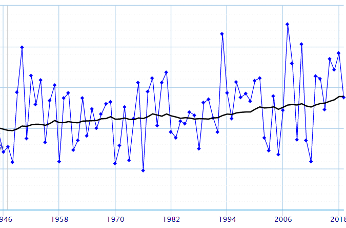
That's definitely not the case in the western lakes. Summers have been markedly wetter. Even in the eastern lakes precip trends seems fairly flat.
MSN summer rainfall trends above for reference
-
1
-
-
winds a steady 20 with gusts into the 30s now. first showers on the doorstep here.
-
15 minutes ago, cyclone77 said:
Not in this sub, but out in Nebraska winds are gusting to 70mph at North Platte. Also 71mph in southeast CO at Springfield.
Yeah the N/NW gusts behind the plains low are more impressive than the Cristobal winds right now. Must be great mixing conditions over there
-
all the CAMs have trended upward with rain in the Madison area this morning. The cirrus canopy is really overspreading the area now
-
2
-
-
13 minutes ago, hlcater said:
Tomorrow’s setup in IL/IN is completely foreign to me and I honestly have no idea what to think of it. Especially the hodographs. 0-6km shear is nothing short of substantial and likely results in storm motions exceeding 40kts, but wind aloft is significantly backed and in much less magnitude. The result is a hodograph I’ve literally never seen before where it doubles back on itself. What the result of this is, perhaps rain on inflow? Similarly, never seen 0-6km shear contrast with abysmally low EBWD that is typically far too low to support supercells. To me, storm speed seems to suggest that this environment appears far more sheared than it actually is in a storm relative sense. If storms can initiate on a confluence zone in S IL or elsewhere, my guess is that we get fast moving clusters of storms and transient supercell structures with perhaps a few tornadoes owing to large SRH values present(note the sounding posted is on the conservative end of guidance) I’d feel better if EBWD and cloud layer shear weren’t in the gutter.
Thermos should be sufficient but not stellar and shear aloft is better with northward extent tomorrow. Definitely interested to see what results from this.based on my thoughts on how the shear will play out, I think the precip core for any cells will get shoved pretty far out of the way for any right moving cells. The strange backing with height is high up enough that it will really stretch out the updraft to the north, away from the track of the storm.. Think some days with nice VBV, except wonkier and probably really messy with low LCLs
-
both HRRRs have precip moving through S Wisconsin fairly quickly tomorrow, between 2-10, with a fairly convective look. Immediately afterwards winds turn to the SW and get very gusty into the overnight hours. The plains wave then moves eastward and that precip rolls in starting Wednesday morning. I'm looking at 3 periods for gusty winds tomorrow 1)ESE winds getting progressively gustier from around 9-2 tomorrow 2) any strong gusts brought down by convective features during the afternoon and evening 3) and perhaps the strongest winds behind the frontal feature after 10 pm.
-
1
-
2
-
-
snowing in Laramie, Wyoming right now if you thought our non-snow season wasn't short enough in the Midwest.
-
 1
1
-
-
got 89'd here today. Feels like I'm living in Dayton
-
4
-
-
hi res models are on the east end of guidance and if they are correct we are going to get poured on
-
Definitely intrigued at the possibility of tornadoes in the NE quadrant of this
-
1
-
1
-
-
Euro trending faster and further west. Has it in SE Iowa on Tuesday evening now
June 26-29 Severe Threat
in Lakes/Ohio Valley
Posted
it was down for about 10 mins but it's back up now. at least on radarscope