

madwx
-
Posts
2,105 -
Joined
-
Last visited
Content Type
Profiles
Blogs
Forums
American Weather
Media Demo
Store
Gallery
Posts posted by madwx
-
-
36 minutes ago, CoachLB said:

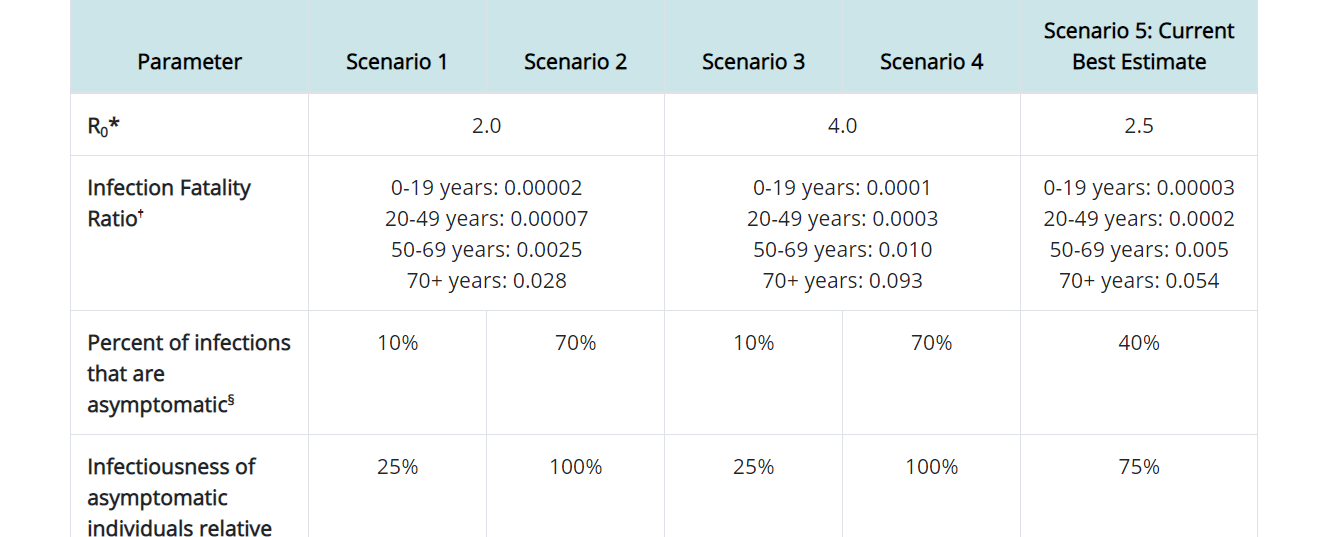
classic misinterpretation of the percentage or as some people like to say today, fake news. The actual data is in a ratio but this mainstream media org just slapped a percent at the end instead of moving the decimal two places to the right like you should when converting from a ratio to a percent. so it's really .003% for 0-19, 0.02% from 20-49, 0.5% for 50-69 and 5.4% for 70+.

-
 2
2
-
-
56 minutes ago, michsnowfreak said:
I just noticed last night's run stopped at 384, but the night before went to 840. Only the 00z though.
i think it takes awhile to load. so it might be many hours before 384-840 come in
-
hit 90 in parts of central Iowa. Wonder if some places further east can hit that tomorrow.
-
41 minutes ago, Hoosier said:
So obviously there has been a lot of attention on older people and those with comorbidities being at greater risk of serious illness, but what about an individual's risk profile changing throughout the year? I haven't heard much about that.
In particular, for people living in northern climates, is your risk of a more significant case elevated in the colder months when you are more likely to have lower vitamin D levels? After all, D is one thing that is thought to play a key role in immune health.
Living in the upper midwest, especially if I had darker skin I would be taking daily vitamin D supplements. I'm as pale as a ghost but I'm still taking daily vitamin D.
-
2
-
-
everything in the house gets a pinkish hue around 5 each night. pretty cool
-
23 minutes ago, Hoosier said:
The smoke looks extremely extensive today. Appears to be stretching all the way toward the east coast.
Yeah we might have weeks of this
-
On 9/12/2020 at 9:50 AM, madwx said:
In addition to the 5 active areas in the atlantic right now(Paulette, Rene, TD 19, 95L in the central Atlantic and the recently added 97L in the far eastern Atlantic) there are a few more areas to keep an eye on.
1. A spin in the Gulf of Mexico S of New Orleans: This area is highlighted by the NHC and it will slowly move SW in the Gulf over the next few days.
2. An area of convection in the SW Gulf of Mexico: not much of anything at the surface but convection has been festering E of Veracruz for at least the past day now.
3. The Euro Ensembles are fairly consistent with a low latitude wave moving off of the Africa coast in the next couple days.
4. Any spinups along the ITCZ, especially just east of the Leeward Islands though this is much more of a long shot.
And if that wasn't enough, the Euro Ensembles are already showing at least another wave or 2 moving off of Africa after this weekend.
An update on future risks now that we have Vicki)
1. The area of disturbed weather in the SW Gulf of Mexico has gotten more convectively active. Euro ensembles more bullish on this system as it meanders through the southern Gulf over the next week.
2. The latest wave to come off Africa looks fairly robust and slow development should occur as it moves across the Atlantic at a fairly low latitude.
3. Have to watch the area off the SE coast for tail end development from the cold front that will kick Sally out. Relative model consensus on an area of low pressure developing and this is a climatologically favored area.
4. Another wave will be coming off Africa later this week, though this one looks to be at a higher latitude so not sure how much potential for development there will be.
5. Very long range (post 9/21) but there is a chance for something out of the CAG off the coast of Nicaragua/Honduras.
-
19 minutes ago, cptcatz said:
Euro showing another low rider heading into the Caribbean, I assume would be Vicky.
Most likely Wilfred or a greek name. Vicky will probably go to 97L as it heads NW from the Cabo Verde islands
-
1
-
-
In addition to the 5 active areas in the atlantic right now(Paulette, Rene, TD 19, 95L in the central Atlantic and the recently added 97L in the far eastern Atlantic) there are a few more areas to keep an eye on.
1. A spin in the Gulf of Mexico S of New Orleans: This area is highlighted by the NHC and it will slowly move SW in the Gulf over the next few days.
2. An area of convection in the SW Gulf of Mexico: not much of anything at the surface but convection has been festering E of Veracruz for at least the past day now.
3. The Euro Ensembles are fairly consistent with a low latitude wave moving off of the Africa coast in the next couple days.
4. Any spinups along the ITCZ, especially just east of the Leeward Islands though this is much more of a long shot.
And if that wasn't enough, the Euro Ensembles are already showing at least another wave or 2 moving off of Africa after this weekend.
-
2007-08 looks like a good analog. Especially if La Nina gets a little stronger than progged. Would take that winter and following severe weather season
-
5
-
-
On 5/18/2020 at 12:07 PM, madwx said:
It's crazy how much wetter the 30 year climate means will be when the data set changes from 1981-2010 to 1991-2020
For MSN
Jan 1.23" -> 1.46"
Feb 1.45" -> 1.52"
Mar 2.19" -> 2.26"
Apr 3.40" -> 3.78"
May 3.55" -> 4.10"
Jun 4.54" -> 5.27"
Jul 4.18" -> 4.51"
Aug 4.26" -> 4.16"
Sep 3.13" -> 3.38" (at least)
Oct 2.40" -> 2.73" (estimated)
Nov 2.39" -> 2.21" (estimated)
Dec 1.75" -> 1.71" (estimated)
Annual 34.46" -> 37.02" (estimated)
Only December and November have seen slight decreases in precip and some months (Apr - Jun, Sep - Oct) have seen significant increases in precip.
Updated the above graph through the summer. August surprising trending drier but that April through July stretch is getting so wet. Annual precip going up at least 2.5" as well. We do wet very well around here.
-
1
-
 1
1
-
-
Spain, France and a few other European countries are having a rough time again. They really took the foot off the gas for social distancing measures and are now paying the price.
-
Another record cold high temp yesterday at 53 complete the trifecta of the past three days. Today’s should be unreachable but the rain and cloud cover has overperformed so you never know
-
5 hours ago, A-L-E-K said:
don't like and bad

Man the arctic is moving to Hudson Bay and you’re just going to have to get used to it
-
 1
1
-
 1
1
-
-
Another record cold max yesterday of 51. Again the earliest it's been this cold for a high, breaking the previous date of Sept 12th.
0.35" of rain yesterday, 1.72" for the month. Steadier rain than was expected today, looks like only slight drying tomorrow before rain moves back in
-
1
-
1
-
-
not only was yesterday a record low max of 54 in Madison, it was also earliest in the season it's been this cool. Previously the earliest min high temp of 54 was September 10th.
-
1
-
-
Record low max of 57 today is definitely in play for Madison
-
9 minutes ago, Brian D said:
Pleasant day today with temps around 70. Quite the seasonal day.
Unfortunately, October weather for next week around here. I like Fall, but the abrupt change is harsh so early in the season.
Seems my forecast of a cooler first half of Sept, with widespread frost/freeze potential in the north areas, should pan out for most.
This guy is good
-
1
-
-
29 minutes ago, Brian D said:
Well, looks like a pretty close forecast. I'll let you guys rate it good or bad.
Enjoy your weekend. Oh, and BTW, expect a forecast for Halloween to be very similar to the Labor Day one.
snow showers on the backside of the low?
-
17 minutes ago, OSUmetstud said:
Spain having big problems again.
The ride never ends
-
Para GFS and both GFS ensembles back the op GFS. Same with the UKMET and the Canadian.
-
1
-
-
the Euro has a pretty radically different look to early next week for the past few runs.
-
1
-
-
Come on guys. It’s not man made climate change, it’s just man made changes to the environment that are making things warmer
-
2
-
-
With another typhoon recurving expect another cold dump during the second and third week of September. Wouldn’t be surprised at some early frosts in northern areas
-
1
-
2
-
Coronavirus
in Lakes/Ohio Valley
Posted
see my post above with the actual CDC data. Fox News was using bad math