madwx
-
Posts
2,355 -
Joined
-
Last visited
Content Type
Profiles
Blogs
Forums
American Weather
Media Demo
Store
Gallery
Everything posted by madwx
-
Who left Beavis in charge of today’s GFS?

-

February 8-9 Should There Be a Thread For This Storm
madwx replied to Hoosier's topic in Lakes/Ohio Valley
-
February 8-9 Should There Be a Thread For This Storm
madwx replied to Hoosier's topic in Lakes/Ohio Valley
Madison got 4.8” of snow and the temp never went below 33 yesterday -
February 8-9 Should There Be a Thread For This Storm
madwx replied to Hoosier's topic in Lakes/Ohio Valley
still at 36 well after the storm has ended here. Arctic air has been completely absent behind ever storm system this winter besides the pre Christmas storm -
February 8-9 Should There Be a Thread For This Storm
madwx replied to Hoosier's topic in Lakes/Ohio Valley
4.8” with snow slowing down. Not looking forward to the upcoming shoveling -
February 8-9 Should There Be a Thread For This Storm
madwx replied to Hoosier's topic in Lakes/Ohio Valley
2.7" of pure concrete so far. been a little over an inch an hour since it transitioned to snow -
February 8-9 Should There Be a Thread For This Storm
madwx replied to Hoosier's topic in Lakes/Ohio Valley
Yeah it’s been coming down big league here since about 830. At least a couple inches on the ground and the wind has picked up tremendously. Had sleet for a couple hours before that and roads were ice covered -
Winter 2022/23 Medium/Long Range Discussion
madwx replied to Chicago Storm's topic in Lakes/Ohio Valley
Sucks to be them -
February 8-9 Should There Be a Thread For This Storm
madwx replied to Hoosier's topic in Lakes/Ohio Valley
Time 2 jackpot -
Winter 2022/23 Medium/Long Range Discussion
madwx replied to Chicago Storm's topic in Lakes/Ohio Valley
at least the sun will be out -
up to the upper 40s. Looking like we'll do this again early next week
-
February 8-9 Should There Be a Thread For This Storm
madwx replied to Hoosier's topic in Lakes/Ohio Valley
looks like MSN is reeling this one in. Partying like it's 2007-2009 again -
February 8-9 Should There Be a Thread For This Storm
madwx replied to Hoosier's topic in Lakes/Ohio Valley
Hoping to thread my morning commute in before the changeover so I can just watch the rippage outside my office window -
February 8-9 Should There Be a Thread For This Storm
madwx replied to Hoosier's topic in Lakes/Ohio Valley
0Z models say wagons SE so far -
snowpack definitely got nuked overnight. Should be down to piles before any snow starts falling on Thursday morning.
-
February 8-9 Should There Be a Thread For This Storm
madwx replied to Hoosier's topic in Lakes/Ohio Valley
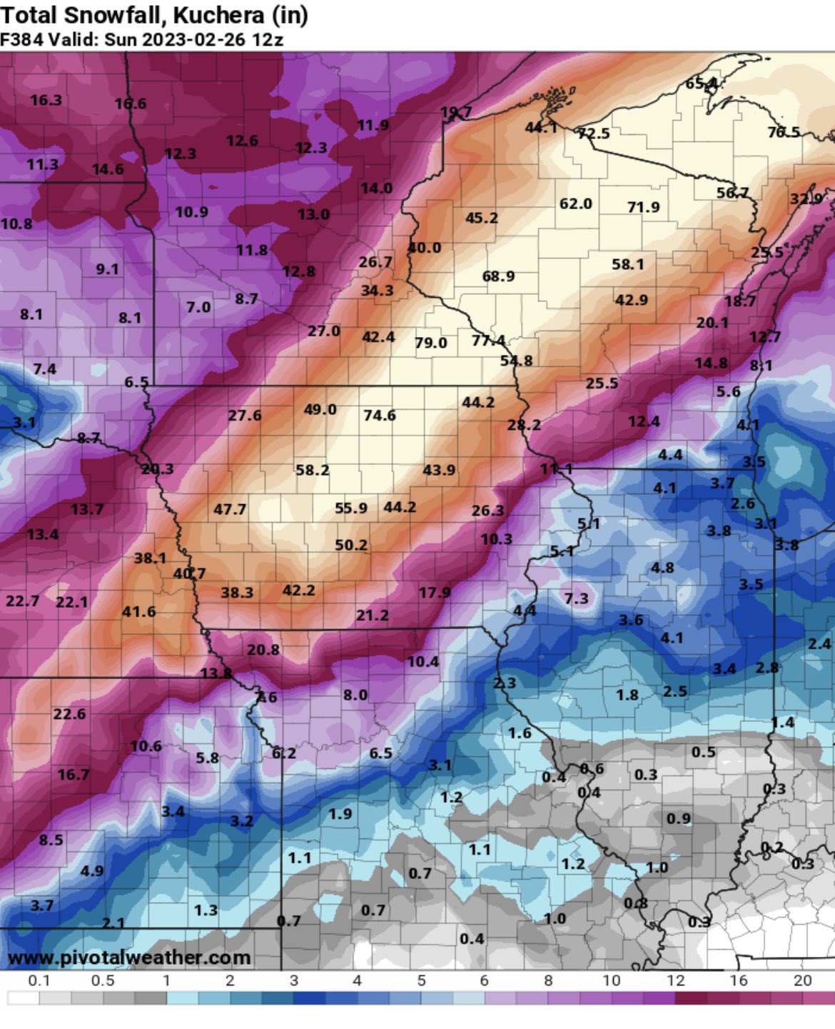
This is a perfect storm to use positive snow depth change model outputs. Kuchera and especially 10:1 are going to to far overestimate actually accumulation along the rain snow line -
Winter 2022/23 Medium/Long Range Discussion
madwx replied to Chicago Storm's topic in Lakes/Ohio Valley
Yeah, this does concern me, but it's not a death knell. Feb 2001 had a SSW and it was at the end of a multi year La Nina and April was above average. -
Winter 2022/23 Medium/Long Range Discussion
madwx replied to Chicago Storm's topic in Lakes/Ohio Valley
5-6-7 is a good way to stay above average through the 18th or so -
on my drive into work, my car thermometer went from 7 to 3 to 11 to 23 in about a 10 mile stretch. So yeah, sorta fake
-
Winter 2022/23 Short/Medium Range Discussion
madwx replied to Chicago Storm's topic in Lakes/Ohio Valley
Yeah if we want to go gangbusters 2/15-3/15 and then go above average temps for the month and a half afterwards I won't complain. -
jumped from 7 to 20 in an hour. so despite the decoupling of the boundary layer, the torch is still on
-
Radiated down to 5 this morning. 11 degrees below the forecasted low
-
Winter 2022/23 Medium/Long Range Discussion
madwx replied to Chicago Storm's topic in Lakes/Ohio Valley
Have to hope this upcoming potential SSW doesn't repeat 2018. 2nd coldest April on record here, only reason we didn't get coldest on record was the fact we hit 81 on the 30th. We got the mega blizzard in central Wisconsin in mid month and Madison got hit with 7.2" the week afterwards. Luckily that melted within 2 days. -
Winter 2022/23 Medium/Long Range Discussion
madwx replied to Chicago Storm's topic in Lakes/Ohio Valley
Calling it a cold sector is very generous -
Absolutely top notch outside. We’re at the point in the winter where sunshine and upper 20s means only wearing a sweatshirt outside