

wawarriors4
-
Posts
1,229 -
Joined
-
Last visited
Content Type
Profiles
Blogs
Forums
American Weather
Media Demo
Store
Gallery
Posts posted by wawarriors4
-
-
I think 53 and 240 should have forecast contest, each can make ridiculous comments that are are off the wall awful, and the winner gets a box........

-
 4
4
-
-
1 minute ago, nj2va said:
God save the queen!
Although some people swear by the UK, I never think its a good model lol
UKMET

-
4
-
-
1 minute ago, mappy said:
Pretty sure it’s from stormchasernick. He’s a CT wx weenie and is well know for his photoshops
Ahh got ya, I'll have to find the tweet/follow his twitter handle.
@mappy yep, there it is, thanks for the info on a good new twitter follow.
https://twitter.com/stormchasernick/status/1354822836267798528?s=20
-
 1
1
-
-
Just now, mappy said:
lol you yanked this from Twitter
A buddy of mine sent it to me earlier today, but yeah I'm sure it's on twitter too, it's comical.
-
2 minutes ago, NorthArlington101 said:
could we suppress that... I dunno... 50 to 100 miles south and slightly west?That would be great, but I’m not holding out hope. This comes to mind.....

-
2
-
4
-
-
5 minutes ago, nj2va said:
Yup, same for me. Give me like 0.5-0.6” QPF as snow Sunday and I could give two Fs what happens with the coastal. Miller Bs hate DC and the trends 00z show why.
And eeeeeek, I just realized you’re a Flyers fan (makes sense with the profile picture!). You just lost a few points for me.

Yeah, I know suppression was talked about a whole bunch, and for a while things moved South, but having lived near Fredericksburg now since 2009-2010 pretty much, I've come to know what usually happens and that's that the CCB pummels NE MD and North of here in general, so I'll take my Snow on the front end and be happy. #JuiceUpTheWAA
-
3
-
-
3 minutes ago, nj2va said:
There’s a scenario where you actually do better than up here IMO. WAA targets Central VA and CCB targets north of Baltimore.
Yeah, I have been following that. I've been hoping to get the WAA part as juiced up as possible, in EZF we get back side lovin as frequently as the Flyers win the Stanley Cup
-
1
-
-
I love when the South Central PA guys come to our sub-forum saying how the GFS looks just awesome for everyone.....**checks notes**.....oh right the GFS shows 25" for you and I get stuck with an 8 incher....not that I'm complaining.
-
3
-
-
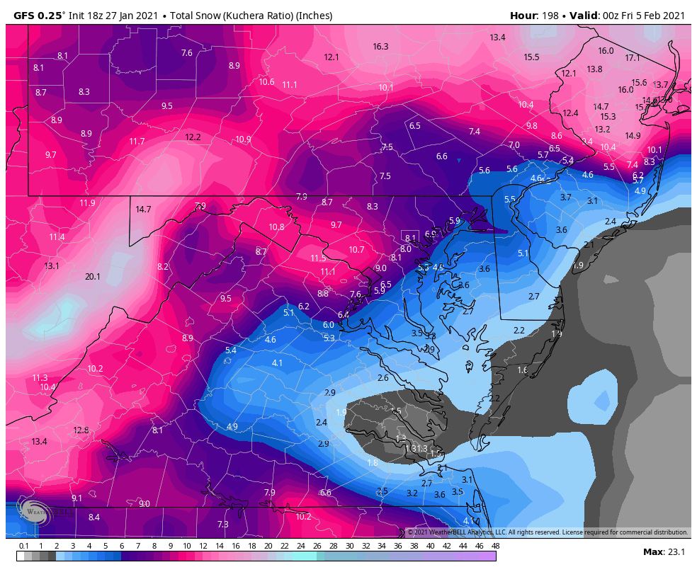
So the CMC wants to go for a nip and a tuck, yet this is what it looks like on the GFS
-
5
-
-
I think @yoda is seeing it here:
https://collaboration.cmc.ec.gc.ca/cmc/cmdn/pcpn_type/pcpn_type_gem_reg.html

-
2
-
 2
2
-
-
LWX AFD Update at 9:00 PM
.SHORT TERM /SATURDAY NIGHT THROUGH SUNDAY NIGHT/...
9:00 PM UPDATE: No change to the previous forecast at this time,
but some increase in expected snow totals may be necessary in
the next shift. Model guidance continue to increase in
confidence of 4-7" for most areas along and west of I-95, with
the higher end of that starting to look a little more likely.
Would like to see another round of guidance before bumping
things up just yet. For now, see the previous update and
discusison for more detailed thoughts.
-
6
-
 1
1
-
-
Oh good 240 is back and I need a 40
-
3
-
-
2 minutes ago, psuhoffman said:
I guess EZF is kinda my line for what is northern v Central VA. Somewhere around there is the divide for the CCB though. But south of there gets some pretty good WAA thump at the start.
5 minutes ago, yoda said:I'd argue even down toward EZF looking at 108-118 for the CCB
Appreciate the EZF love Yoda.....know what usually happens down here. A warning level storm will be great, any CCB love would just be a bonus!
-
2
-
-
18 minutes ago, Ephesians2 said:
Light coating on grassy surfaces with moderate snow ongoing. It took about an hour of light/moderate snow falling without accumulation before it started to stick.
I take it your in Lynchburg this evening. Hoping to score a coating up around Fredericksburg and then take our chances with whatever happens on Sunday/Monday
-
1
-
-
2 minutes ago, WinterWxLuvr said:
Ok we’ve got a new one you’re gonna love
9 posts and I’m sure 8 of them at least are cringe worthy
eta: goes back to what @leesburg 04 said....when you see the last lost is from certain posters best to not even open the thread
-
Just now, WinterWxLuvr said:
I love when a new member decides he’ll populate the storm thread with one negative post after another.
It’s really excruciatingly frustrating, and I don’t get it. Every time I see a panda picture I shiver......
-
5 minutes ago, psuhoffman said:
Lol at ppl tossing this

like it’s garbage. Yea it’s not the euro hecs but a 5-10” area wide snowstorm is not something you label a fail unless you have no concept of our climo.
Fredericksburg falls in the “screw zone” on the 18z GFS and still gets ~6” so yeah it’s nice and it’s moving a certain way....I’ll take that!
-
1
-
-
Just now, stormtracker said:
I think that most of my fellow DC'ers would take the gamble on sleet to get something like this?
No doubt, even down here in EZF. Sleet is part of the game to get big snow
-
2
-
-
Sleet making it into EZF is no big thing, that usually happens when we have a big one and is the cost of doing business around here. EURO looks good!
-
4
-
-
Heavy Sleet with a bit of rain, 32.7, deck, walkway, yard and cars covered with sleet
-
Heavy Rain in NW Stafford and 33, occasional mangled flake too
-
Sleet just starting to mix in with rain NW of Fredericksburg, currently 33.9
-
Just now, Deck Pic said:
Maybe changing to snow in Southern Fauqier? Which obviously means school is cancelled until summer
I’m not too far away from southern Fauquier, in NW Stafford. Still just rain here, down to 34.3
-
1
-
-
Light Snow here just NW of Fredericksburg
-
1
-

January Banter 2021
in Mid Atlantic
Posted
Haha you know things have gone to crap around here when there’s been 27 minutes between posts in the main thread for this “storm” 24 hours before it’s supposed to begin.