

cbmclean
-
Posts
3,078 -
Joined
-
Last visited
Content Type
Profiles
Blogs
Forums
American Weather
Media Demo
Store
Gallery
Everything posted by cbmclean
-
Shouldn't have too much dust on it. Didn't we just have a nice cross-polar episode a few weeks a when we had our big cold shot?
-
I will accept the existence of a -NAO when it happened a week ago. Actually, scratch that, -NAOs can exist in March - November, just not in Dec - Feb.
-
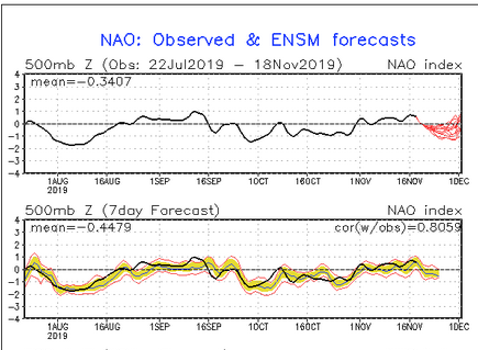
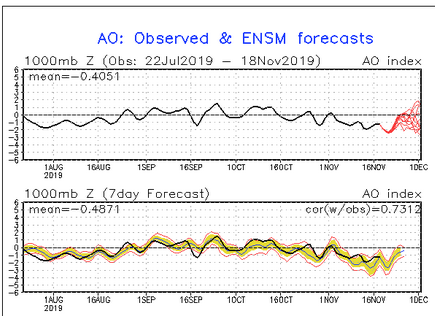
For what it is worth on the cpc page giving the NAO/AO conditions, the label says 500 mb for the NAO but 1000 mb for the AO. .
-
Still trying to sort out my Pacific teleconnections. So a -PNA pattern can come and go relatively quickly, but a dreaded +EPO will embed itself for weeks?
-
This sounds like textbook advertisement for setting one's expectations based on the median instead of the mean.
-
Right now ( I mean this past decade) reality is skewing warm. I think that frustrates most people on this forum, which makes us quick to lash out. I know I constantly have to fight against a natural desire to pay attention when someone predicts "COLD COLD", but dismiss those saying "WARM, WARM" as idiots.
-
27 °F?
-
December 2015 will haunt my dreams for a long time, and not in a good way. Down here in NC we were 70+ for like two weeks straight. It was a warm, soupy airmass as well. Didn't get below 60 F for days on end at night. Mosquitoes and gnats were buzzing. Had to cut on the AC. I think it actually ht 80 F on Christmas day where I was.
-
For those counting, it has been precisely 40 days since RDU notched 100 F back on October 3. 40 days between the last (and only 100 F) day of the year and the first sighting of frozen precip at RDU. I wonder if that is a record.
-
Ah, hello guys, its your brother-from-another-mother down south. I will be lurking around here because this continues to better sub-forum than my home, as far as hardcore meteorological analysis. I was considering looking into the MJO forecasts but I am concerned I am am just starting the pain early. Still having flashbacks from last year's leisurely grand tour through the ugly phases, followed by a lightning rocket through the good, right back to bad.
-
Got down to 28.6 F last night.
-
I was coming here to post the exact same thing. A good explanation of why we so often fail. I wonder what it is about the Appalachians that make it so hard to resolve.
-
Got down to 27.3 last night. Not bad for the first third of November in the Coastal Plain. Hope all the gnats have gone to meet their Maker.
-
I would find it hilarious if even one token snowflake was sited ~ 6 weeks after we hit 100 F at RDU.
-
Yeah, but these days, we tend to bust climo the other way. I'd be happy to just have a cool crisp November.
-
It was at the tail end of December 2017 and the beginning of January 2018. RDU set their record for most consecutive hours below 32F: Just under 10 days. Some areas of the Pamlico/Albemarle sounds froze. Got down to 0 F at my house in Wilson, which is quite an accomplishment.
-
I agree with your overall point, but less than two years ago we had a generational 10-day cold spell in NC at least. We've had three or four equivalent warm spells though..
-
Is it too early to start looking for a fantasy -NAO? From the CPC 8 - 14 day forecast. One feature being closely monitored is the potential for ridge development over the North Atlantic south of Greenland (shown by the GEFS and ECMWF ensembles). Should this feature develop, this would teleconnect well with increased troughing across much of the Eastern CONUS. Nothing could go wrong here could it?
-
Really more of a banter post but maybe you guys will indulge me. Realities that I need to learn to accept . 1. There is nothing remotely fallish about September now. It is August part deux. 2. December is a fall month (except for random episodes like our early snow last year) 3. February is a spring month. 4. The NAO/AO will be positive (except maybe in March/April). Do not believe any forecast which shows them negative for a significant period of time. 5. The SER loves me and knows what's best for me. 6. Repeat: the NAO/AO will not be negative. Do not buy into the weekly forecasts 7. Whenever models disagree, always trust the warmer one. 8. Seriously: do not expect the NAO/AO to ever go truly negative in DEC - FEB again. 9. Models will flawlessly pick-up on warm spells except they underestimate their intensity .
-
Wow. 1954 was a miserable early October.
-
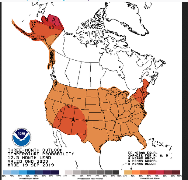
Even better is the experimental 12.5 month forecast for Oct-Nov-Dec 2020. The good cheer never ends.
-
Amazing how warm 1925 was; must have been awful in those pre-AC days looking forward to Fall relief and getting a face full of high summer. Also, amazing how soupy last year was at Asheville.
-
Where were you located?
-
One thing has me perturbed. A few days ago it looked as if the front was going to stall and we would get several days of elevated rain chances. Now it's going to barrel through in one day. If I miss out on Tuesday, it's dry for another week. I'll be anxious all day.
-
Don't look over in the MA forum. They have a thread already cancelling this upcoming winter.


