

cbmclean
-
Posts
2,592 -
Joined
-
Last visited
Content Type
Profiles
Blogs
Forums
American Weather
Media Demo
Store
Gallery
Posts posted by cbmclean
-
-
22 minutes ago, ravensrule said:
You could never top one of Ji's posts.
I think he did. Ji's posts are emotional outbursts of frustration. The recent PSU post is just data. Cold, hard data. It can't be bargained with, it can't be reasoned with, and it absolutely will not stop until we are all curled up in a ball in our bedrooms with the blinds closed and clutching an old farmers almanac.
-
4 minutes ago, psuhoffman said:
Now that I am home with the data in front of me...I will answer this...but its gonna hurt.
I for one am proud that I had a hand in inspiring PSU to create this masterpiece. I think this may set a record for most crushed hopes and dreams by one post.
I noticed in the stat pool that this nightmare actually repeated in THREE CONSECUTIVE YEARS: 1989 - 1991. Can you imagine what would happen to this forum if that stretch were to recur?
Actually, that gives me a sliver of hope. We have been at a place approximately this bad before, once for three straight years. So maybe we can recover from this in future years.
-
8 minutes ago, psuhoffman said:
That look actually isn't too far from a workable one. As is that would be mostly a cold dry look after the wet look the first week which I suspect is from a cutter to usher in the pattern. BUT...get the trough to hang back into the SW a bit more to create a positively tilted trough with just enough SE ridge and it becomes a good pattern for progressive waves. I would take my chances with that look. Its a stones throw from a workable look unlike what the Euro weeklies suggests with is pretty much a no hope shut out the lights for the entire season look. However...I am about to drop what is going to be the least popular post in americanwx history.
Oh poopy.
-
21 hours ago, psuhoffman said:
THe EPO is actually typically positive during these events. It is hard to have extreme blocking on both sides.
@PSUHoffman
I seem to remember you debating this with someone last year. Seems like their argument was that it was physically impossible to get significant -EPO and significant -NAO at the same time. You retorted that it was indeed possible and pointed to a specific time frame. Can you remember any instances of this? I think some may call it a "ridge bridge".
-
1 hour ago, snowfan said:
Was up in new england over the weekend. Rough conditions at every ski area I saw.....Loon, Cannon, Bretton Woods, Attitash, and Wildcat. And, so much brown ground all over outside the mountains.
I was under the impression that they had had a snowy December.
-
23 minutes ago, Mersky said:
With average temps reaching their lowest point around the 3rd week of January I wouldn’t say the days 14-21 are a torch for the area.

I think this map is just comparing the Ensemble Mean temp forecast between the 12Z and the 0Z. It doesn't actually show the forecast anomalies.
-
Just now, BristowWx said:
I don’t think I could unless it was a challenge that everyone did it. We need some extreme measures in an extreme pattern.
I think I will try to at least get through tomorrow without peeking.
-
Just now, BristowWx said:
let’s just all log off the site for 5 straight days and make a binding pact not to look at anything weather. Every thread no members browsing. Then all log back in Saturday and see where we are at. Who’s with me?
I really should but I know I don't have the will-power. I also want to follow the Day 7 - 9 cool shot to see if it can at least throw you guys a bone.
-
23 minutes ago, LP08 said:
I know the weeklies suck but I just browsed through them. Not good. Maybe some signs of some -epo help after week three but absolutely no help in the artic. If this is the look in mid February....yikes.
Well, according to PSU's analysis, once that ridge show up, it stays all winter (yuck). Apparently the one and only way to avoid the doom is to have a stout -NAO. Since the weeklies are seeing the TPV hovering over the NAO area the whole period, it is therefore bound to predict hot garbage.
So our only hope is simply that an unanticipated NAO pops up at some point. It is just that simple. I think Bob was saying that we did have a brief period of NAO blocking pop up in the medium range right around the beginning of the Pac puke, so maybe it can happen again.
-
Nose of doom pattern just starting to peak into under 10 days on the EPS. Maybe one day we'll have a really good pattern show up at d15 and inexorably march forward in time.
-
7 hours ago, MillvilleWx said:
Yesterday was pretty much a perfect day in the NFL. Ravens won without even playing some of their top guys, broke records along the way. Pats lost to Dolphins. Eagles/Cowboys drama was settled. Bengals beat the Stains. Pats lost. I won some money in DraftKings. The Dolphins somehow beat the Pats. The Seattle/SF game was a hell of a way to end the regular season. And the most important thing is the Patriots lost AT HOME to the Dolphins. I was literally laughing hysterically at the Twitter feed from the Pats handle when they posted the final score. It was both sweet and salty from all the tears of Pats fans. It's going to be great when Brady and Bill retire, and they fade into obscurity.
I'm a Dolphins fan so I "hate" (sports hate, not real hate) Brady and Belichek as much as anyone, but do you really thing they fade into obscurity after six superbowls and the longest stretch of sustained dominance in NFL history, heck maybe in all North American team sports history?
-
On the other hand, I have also seen some speculate that decreasing temp gradients between the tropics and polar regions should lead to a weakening in the polar jet. I would assume that would mean more time in the -AO mode. Sure aren't seeing it this winter though.
-
 1
1
-
-
1 hour ago, donsutherland1 said:
There may be reason for concern. Some recent scientific literature:
I saw this article earlier, maybe on this site last winter. It chilled me to the bone. Imagine in the future, 9 out of 10 years with never-ending Pac puke.
-
1
-
 1
1
-
-
5 minutes ago, psuhoffman said:
Looking at all the analogs to a strong central pac ridge in January, most had that feature persist at least to some degree into Feb and March.
I think you may have posted this before, but how many years were in your analog pool for Pacific Doom Blob? Apparently there at least a few where the blob died earlier than others? I know I'm reaching for straws here, but not much else to do.
-
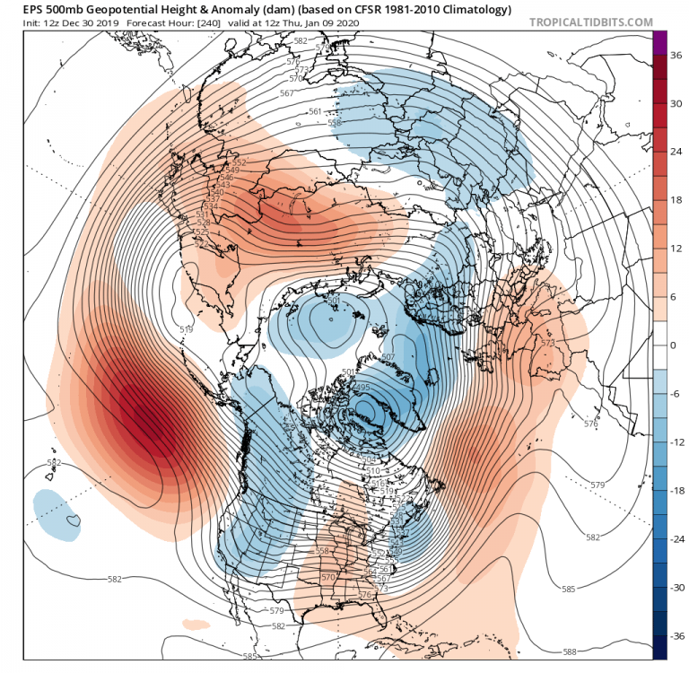
6 minutes ago, cbmclean said:
If you cycle through the GEFS to the very end, if you squint real hard you might be able to see it weakening and slowly migrating east. TPV is absolutely nailed to Baffin Bay.
Sorry, the "it" I was referring to was the Pacific Doom Blob.
-
If you cycle through the GEFS to the very end, if you squint real hard you might be able to see it weakening and slowly migrating east. TPV is absolutely nailed to Baffin Bay.
-
12 minutes ago, psuhoffman said:
And even assuming the wave progresses thats still 2 weeks away from getting to cold phases at day 15 and the last attempt at that feat died.
I can't wait for it to start doing curley-cues
-
Well, I find it interesting, in a masochistic way, that the models, especially the EPS but all of them to some extent, have been able to zero in on our fail patterns super far out. Impressive work on their part.
-
1 hour ago, nj2va said:
I really wanted the Eagles to lose...here’s to them getting beat next weekend at home (which is a joke they get to host a playoff game).
Don't make PSU mad - I hear he has the power to cause a bad pattern.
-
 2
2
-
-
20 minutes ago, Kevin Reilly said:
There really hasn’t been a significant NAO block December to March really since 2009-2010? We scored big December 23rd 2009 and February 23rd or so 2010 off a negative NAO. Correct me if I’m wrong. Now of course NAO was negative on October 30th for Sandy 2012.
I think we have had several recent -NAO episodes in march. It's kind of a running joke int he SE forum. I think there may have even been one last year.
-
6 minutes ago, osfan24 said:
Far too early to punt this winter, but getting the vibe we may have to pull off a 2016 type event where we get super lucky with timing to salvage this winter at all. Otherwise, it could be like 2016 minus the blizzard.
So in others words, like 2016 in the SE forum area.
-
1 minute ago, psuhoffman said:
What happened? I miss something?
Looks like he may have ran afoul of one of our local moderators. All his posts seem to have vanished.
-
Status report from MA thread: Cool gradient pattern setting up day 9 - 10. If they get lucky they could end up on the right side of the gradient, but generally pessimistic based on previous gradient patterns. Verbatim, the pattern setting up after day 12 or so on all three major ensembles, is the kind that makes women faint, strong men weep, and dogs hide under the beds.
My own extrapolation for us: no reason to get excited about any winter weather potential for the SE. Should hopefully have a couple of days cool/coldish days but little hope for anything else.
-
5 hours ago, mackerel_sky said:
but the GFS looks to have backed off it’s extreme cold around the 7th or 8th
Shocking.
-
2
-

Mid to Long Term Discussion 2020
in Southeastern States
Posted
I'll just leave this here. Sleep tight.