

cbmclean
-
Posts
3,065 -
Joined
-
Last visited
Content Type
Profiles
Blogs
Forums
American Weather
Media Demo
Store
Gallery
Posts posted by cbmclean
-
-
27 minutes ago, leesburg 04 said:
I watched the history of food in America on the history channel last night. It was pretty fascinating...the candy bar wars were pretty wild from Hershey to Mars to Curtiss. I didn't know that Hershey fired some dude named Reese and he said oh yeah mother****er watch this!! I also finally learned what M&M stood for.
You mean they actually had history on the History channel? I thought it was 24 hours-a-day of Alaskan gold prospectors and crab fishing.
-
 2
2
-
-
12 minutes ago, psuhoffman said:
It was only like 2 people canceling winter after this week and one was Ji who should count as -1.
So does that sum up to 0?
-
Quick question. What the heck is the RDPS?
-
34 minutes ago, Iceagewhereartthou said:
Based on what was advertised, almost unanimously, it's one of the bigger disappointments and rip offs I can remember. Definitely hard to swallow.
Winter weather fail lesson #17235:
If the HP isn't in the right place, the cold air ain't getting past the mountains, not matter what the models show.
-
3
-
-
1 hour ago, NorthHillsWx said:
18z GFS for 12z Tuesday
Incredible.
-
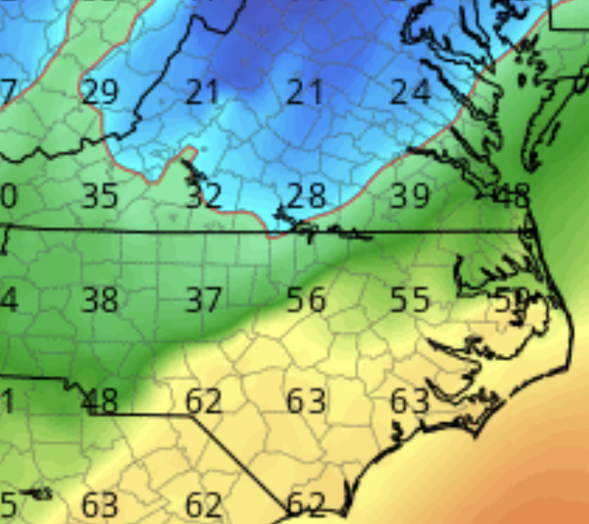
14 minutes ago, NorthHillsWx said:
Most insane temp gradient I’ve seen in N.C. Mid 20’s at Kerr lake and 60’s wake county
Model and time?
-
So hypothetically, what would it take to get that arctic air pointed at us instead of just battering helplessly against the mountains. Where should the HP be?
-
6 minutes ago, eyewall said:
Raleigh came in with a tough discussion to read for those hoping for next week:
Significant model disagreements remain for Monday night into Tuesday
morning. ECMWF has been taking the surface low west of the mountains
while the GFS has been keeping a secondary low offshore. Recent runs
of the GFS However have started to trend more towards the Euro,
which would yield a warmer solution with most of the Mid-Atlantic in
the warm sector.  There will be an influence of northerly flow at
the surface  to begin the day with cold air trying to make its last
efforts to move into the area before the strengthening surface low
pressure system in the Deep South moves into the Ohio Valley.
Biggest threat looks to be a brief period of freezing rain early
Tuesday morning quickly changing to rain by late morning. Still more
details needed to be sorted out for this period as uncertainty
remains high. Tuesday both long range models are in good agreement
that the aforementioned low pressure system from the Gulf will
slightly strengthen and move up across GA and to the west of our
region. Rainfall is expected to last through Tuesday ending late
Tuesday night into early Wednesday morning. Expect dry conditions on
Wednesday with temperatures in the 50s.
Yeah that was a bit of a gut punch. Its completely reasonable to be negative about our chances now.
-
1 minute ago, MillvilleWx said:
I still can't believe the temperature numbers being spit out on guidance down here. It's gonna rival 1985 in some regards which is the holy grail of cold for Midland. That and 1962. Add snow to the mix, and it could top it. I'm giddy and also already cold lol
After you have had your fill, can you please give it a push to the east? The cold seems to be hung up on the mountains. See if you can unsnag it please.
-
So, how bout them Caps?
-
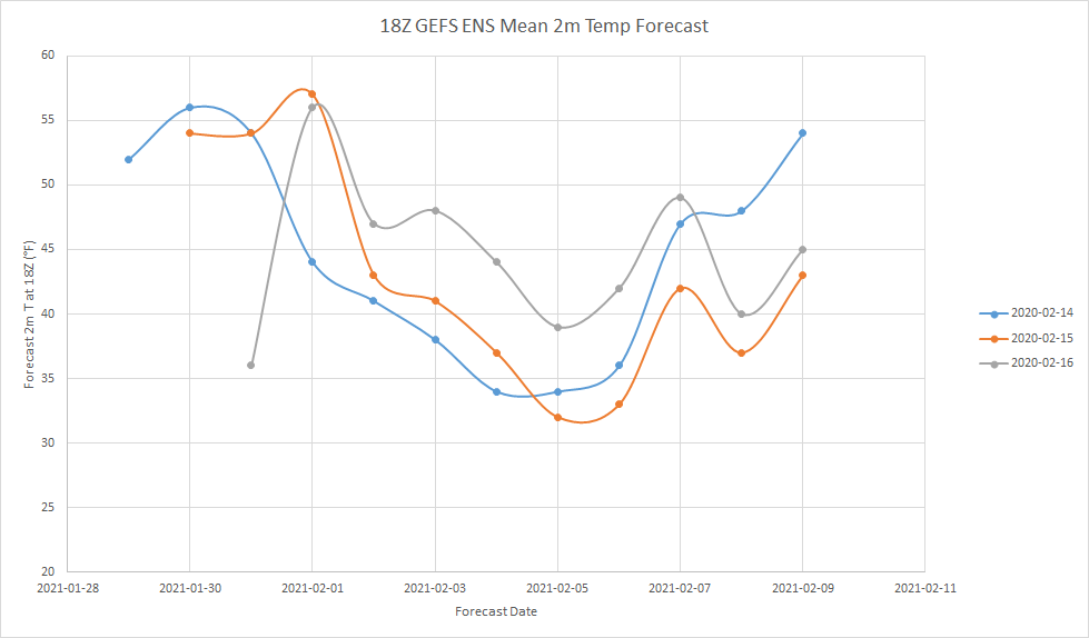
In depressing news, here is a graph I made of the long sad story of the 2m temp at 1 pm for one particular gridpoint in central NC according to the GEFS for the days Feb 14 - 16. A tale of opportunities missed.
-
 1
1
-
-
22 minutes ago, griteater said:
Tonight's WPC Forecast map for Day 7
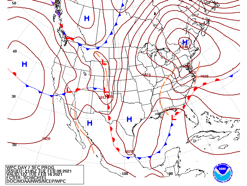
Well someone earlier was saying they they wish they had a 1044. Ask and ye shall receive. Until the next run taketh away.
-
Weenie fight between psu and loosetoa6.
-
5 minutes ago, PhineasC said:
You would think Brady is partying tonight, but like the true greats he is probably back in the film room analyzing tape to see his mistakes and then hitting the gym.
He is that kind of guy. In ages past, he would have been a warlord commanding huge armies. LOL
If he never enjoys what he accomplishes, what is the point of accomplishing it?
-
3 minutes ago, magpiemaniac said:
The 00z GFS tonight isn’t looking so good.

That would be disappointing, concert in Brownsville TX than at RDU. But the models seem to be completely unable to pin the PV down. I wouldn't say we are out of the running yet.
-
2 minutes ago, magpiemaniac said:
No luck with that historic cold next week. That’s some rare air and we won’t experience it.
According to which models at which times?
-
3 hours ago, Wow said:
18z gfs is a dumpster fire. Ridge holds over the east coast. Who the hell knows whats going to happen
18Z GEFS was also a bummer. A ~6 F jump in average temperature at 1 pm from the 18Z yesterday in central NC . The big cold was completely lost. So I am assuming that the PV must be in the west this run.
That PV is driving me insane.
-
3 minutes ago, Bob Chill said:
The older I get, the more I accept unknowns in wx. Even in the very short range. You dont have to know everything in advance to have a good time in life. Sounds easy but hard to stay in that lane, but I spend more time in that lane than anywhere else lately. Only took me 15 years

ETA: I'm sure you have a problem with this post but.... IDFC
You have an impressive variety of minced oaths.
-
15 hours ago, CAPE said:


The disaster continues unabated in the SE thread as the bodies of those who already jumped are cushioning the fall for the rest of us so we can't even self -reap.
-
1 minute ago, JakkelWx said:
The eastern shore is the southeast of the Mid-Atlantic forum.
Trying to horn in on our fail cred?
-
We in the southeast are lining up at the cliff.

-
9 minutes ago, psuhoffman said:
no that was 2015. December 2016 was when we had that 30" overrunning storm for like 3 runs then the STJ remembered it was a nina and just disappeared. It ended up a weak arse 1-2" wave instead.
Yeah it was 2015. I think it literally hit 80 F in Fayetteville NC where I was. There were merry mosquitos for Christmas.
-
26 minutes ago, MillvilleWx said:
A LITERAL line of storms in Alabama/Mississippi right now. I'm actually stunned

After you posted that I took a quick peek into the SE forum severe weather thread, but no activity there since Jan 28th. Kind of surprising.
-
1
-
-
So we have Stormtracker as an administrator and Mappy as a moderator. I also think we have one admin and one mod in my home SE thread. So is this site organized so that there is one of each for each regional form? You'd think I'd know this after hanging out here so long.


February Banter 2021
in Mid Atlantic
Posted
Glad to see something trending well for once for you guys. I now return to my endless CAD rain event here in NC.