

jm1220
-
Posts
26,186 -
Joined
-
Last visited
Content Type
Profiles
Blogs
Forums
American Weather
Media Demo
Store
Gallery
Everything posted by jm1220
-
Extreme Cold, Snow & Sleet: SECS 1/24 - 1/26
jm1220 replied to TriPol's topic in New York City Metro
It hits a snag here or there but yes. It’ll be on our door by 3pm, then question is will it come through or hit more snags. -
Extreme Cold, Snow & Sleet: SECS 1/24 - 1/26
jm1220 replied to TriPol's topic in New York City Metro
Newest HRRR continues to have the sleet line fight back and forth as it gets to NYC around 21z. Sleet finally really takes over around dark. If that's true could be big, and NYC gets over a foot. -
Extreme Cold, Snow & Sleet: SECS 1/24 - 1/26
jm1220 replied to TriPol's topic in New York City Metro
Sleet will accumulate too just at a slower rate. If we get 0.6” liquid as sleet that’s 1.8” since it’s a 3-1 ratio. And it will be dense and heavy as hell. -
4” on my deck but snow blowing around makes it harder to get a good measurement. Heavy snow.
-
It's counting sleet as snow. It's nowcast time and watching the radar.
-
Getting heavier here again after a lull.
-
Extreme Cold, Snow & Sleet: SECS 1/24 - 1/26
jm1220 replied to TriPol's topic in New York City Metro
New HRRR really has a fight with the sleet line as it comes into NYC around 3pm. Pushes it back south and soundings look right on the edge. Please be right lol. -
Extreme Cold, Snow & Sleet: SECS 1/24 - 1/26
jm1220 replied to TriPol's topic in New York City Metro
Yep, if we can get it to fight back and forth for a while, even an hour that could mean 2 more inches. The radar looks amazing coming out of NJ. The ratios are coming down as the column warms but higher intensity will make up for it then some. That looks like 2”/hr stuff coming. -
PHL radar looks amazing-here comes the money 4-5 hours.
-
Extreme Cold, Snow & Sleet: SECS 1/24 - 1/26
jm1220 replied to TriPol's topic in New York City Metro
Download RadarScope and use Correlation Coefficient. The yellow line is where sleet mixes in. This was as of a few minutes ago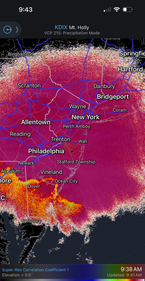
-
That stuff over SE PA will pound us for a few hours.
-
FWIW the 3k NAM has sleet to Staten Island by about 2pm over to I-80 in NJ and to the Tappan Zee/my backyard/West Milford by 3pm. It's quite wet, 1.5" liquid or more for most.
-
2.5" here just about.
-
Extreme Cold, Snow & Sleet: SECS 1/24 - 1/26
jm1220 replied to TriPol's topic in New York City Metro
Doesn't look like it's moving north all that fast over DE and hitting some resistance over DE Bay. I'm sure it's still coming but time to watch the radar and the CC line from here IMO. And heavy enough rates can overcome a very shallow warm layer a little above freezing which is probably what the HRRR is showing with the fighting back and forth. -
I think there's a freezing rain zone later just a little bit inland in NJ, hard for me to see how this kind of cold surface air gets dislodged. Still in the mid teens there.
-
Thankfully the Austin TX area which I'm very familiar with got mostly sleet with some ZR. Would have been devastating if the 0.5" liquid fell as all ZR. It was kind of a crap shoot as to whether the cold surface air would be dense enough to refreeze the raindrops. In the areas where not, it was clear this would be a devastating event in places.
-
Extreme Cold, Snow & Sleet: SECS 1/24 - 1/26
jm1220 replied to TriPol's topic in New York City Metro
Heavy snow rates=warm air advection. Not surprising to me, we just have to max out what we can while we have the cold enough mid level air. It’s a SWFE and these type of storms will always behave accordingly when we have retreating confluence. Enjoying the heavy snow and closing in on 2”. Should end up with 8” at least before sleet which should add up to a couple more inches. A little freezing drizzle to freeze it all up and weenies here will be happy for a long time. -
Extreme Cold, Snow & Sleet: SECS 1/24 - 1/26
jm1220 replied to TriPol's topic in New York City Metro
It seems more NW/SE oriented with the mix line so far and even the HRRR now gets sleet briefly into Rockland/N Passaic before it mixes out, then it seems to fight back and forth for a while even into northern NYC/North Shore. I-84 which will be a little north of the mixing over to Boston which should get additional snow on Mon with the coastal storm will be the jackpot axis here. But that doesn't lower the impact here or where it mixes for a while IMO since it will all have the same water content. -
Extreme Cold, Snow & Sleet: SECS 1/24 - 1/26
jm1220 replied to TriPol's topic in New York City Metro
Pretty sure they don't. On the NAM at least I noticed that once the sleet line was through it stopped adding snow. Like it or not the warm mid level thermals group seems to be winning out. The NAM's been steady enough with it that it's clear it was onto something. But it won't matter if we get upward of 2"/hr before the sleet and a couple inches of sleet on top with some freezing drizzle to cement it all up. It'll suck to shovel/move it, roads will be horrendous because sleet is a lot harder to really get rid of and it will last way longer because it'll turn into a brick. -
High end moderate here, looks amazing. The ratios will lower to close to 10-1 as the warm mid level air comes in but the intensity will increase.
-
You'd have to check the soundings but the sleet line's coming north pretty steadily. Gets held up here and there but no major issue I can see vs guidance. We have until 2-3pm to really clean up (around the city), maybe 4pm for Suffolk County. New incoming 12z HRRR gets sleet into the city/I-80 around 3pm and east from there to most of Suffolk by 4pm but it fights back and forth for the northern part of the city and LI for a time. Hopefully those fights back and forth can buy us another inch or so. At the end of the event there should be some freezing drizzle in the dryslot before it all freezes up. This will be really bad to try moving. Might be a good idea to shovel right before or as it changes to sleet.
-
I cashed out from NYC and put my money into yes for 20"+ in Boston and a little on 24"+. I'm thinking under 10" too especially how they measure but it should really rip until 2-3pm when sleet will barge in. And then it's a question of how much QPF as sleet, that counts too.
-
Just over 1" here.
-
Extreme Cold, Snow & Sleet: SECS 1/24 - 1/26
jm1220 replied to TriPol's topic in New York City Metro
Yep, we're gonna have fun the next 6 hours. -
Extreme Cold, Snow & Sleet: SECS 1/24 - 1/26
jm1220 replied to TriPol's topic in New York City Metro
It's going to be a fun few hours before the sleet gets here. Could be 2+/hr. Let's hope anyway. I just don't buy that south of White Plains it won't be all sleet for a while. Hopefully I'm wrong.


