It's Always Sunny
-
Posts
1,947 -
Joined
-
Last visited
Content Type
Profiles
Blogs
Forums
American Weather
Media Demo
Store
Gallery
Everything posted by It's Always Sunny
-
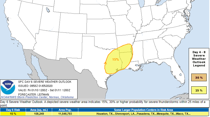
 Bit of a west tick puts Dallas in the 15% risk now:
 -
Analogs suggest a lower MS Valley outbreak as of right now.
-
Models trended slightly east overnight which doesn't surprise me. DFW was on the western fringe to begin with but still plenty of time for models to change:
-
Given the pattern this month could see a couple slight risk days here in N TX and parts of the SE as well.
-
Probably for the panhandle everywhere else will be rain.
-
MO/KS/AR/OK 2019-2020 Winter Wonderland Discussion
It's Always Sunny replied to JoMo's topic in Central/Western States
Dynamics are pretty good looking at soundings if you wetbulb you may be able to get a least a couple inches out of it. Stark north-south gradient with this system. -
MO/KS/AR/OK 2019-2020 Winter Wonderland Discussion
It's Always Sunny replied to JoMo's topic in Central/Western States
I wouldn't expect much more unfortunately. GEFS has that mid-level trough pretty much locked in at this point, leaving most of northern AR out of the mix but central MO could get some good snow out of this with a nice 850mb frontoband set to sweep through there. -
2019 ENSO
It's Always Sunny replied to AfewUniversesBelowNormal's topic in Weather Forecasting and Discussion
I like what it is doing as well and agree with it to some degree, considering the continuous push of warm water east however is this model taking into assumption more warm water pushing east from Maritimes in conjunction with a modeled weakening of trade winds? -
There was some considerable low level dry air associated with this anafront which gobbled up a lot of what little QPF there was to begin with. That, along with a more pronounced warm nose than modeled was the nail in the coffin for any wishful snow chances here.
-
2019 ENSO
It's Always Sunny replied to AfewUniversesBelowNormal's topic in Weather Forecasting and Discussion
You think that developing EWB over Nino 4 will put a bit of a damper on the anomalous warm water pushing east? I still think it'll be enough to warm Nino 3.4 but maybe not quite as much as we think? I still think CFS forecast may be underdoing it a bit but that's just my opinion. -
NW and W of the Metroplex I think it's certainly possible but as you get further east I think that risk drops off considerably. 12Z GFS give Stephenville and Granbury a brief shot at some wet snow overnight tonight but I wouldn't expect anything more than a coating. Western Fort Worth I think even has a slim chance to see some mixing for a brief window.
-
Meh. If that happens precip will likely get shunted further south so it wouldn't matter. I think even if your scenario panned out lower levels will still be too warm unless it miraculously wet-bulbs to 0C.
-
2019 ENSO
It's Always Sunny replied to AfewUniversesBelowNormal's topic in Weather Forecasting and Discussion
Hey @raindancewx a bit off topic but does La Nina generally correlate with an increased -EPO frequency since La Nina's usually result in the jet stream "buckling" over the Gulf of Alaska? Would the opposite be true for El Ninos (+EPO)? -
You mean zero chance of snow north of I-20? Going to be all rain here...
-
2019 ENSO
It's Always Sunny replied to AfewUniversesBelowNormal's topic in Weather Forecasting and Discussion
Also just another observation the EWB over Nino 4 may start to erode the warmer waters as shown in the loop above which may keep downwelling KW in check which remains to be seen. -
2019 ENSO
It's Always Sunny replied to AfewUniversesBelowNormal's topic in Weather Forecasting and Discussion
Appears another downwelling KW is initializing in Nino 4. Assuming it sustains its anomalous warmth and movement east could see a warmup in Nino 3.4 in the next month or so however a bit of upwelling is lurking in Nino 3.4 so bears watching to see how much this downwelling KW sustains its warmth as it interacts with potentially cooler waters. Not expecting that upwelling KW to surface until it reaches Nino 3. -
At least the ensemble charts appear to latch onto the synoptic setup so I think it's safe to say we have the stage set for some winter weather in the Southern Plains depending on where you are.
-
-EPO/+PNA combo looks pretty good just depends how far south it allows that cold air to spill. North Texas could be in for some FZRA if the QPF is there to support it on Sunday PM/Monday AM but GFS looks a bit dry with most of the precipitation to the east (actually where you are)...but it is the 264 hour of the GFS so we all know how little weight to put in that.
-
2019 ENSO
It's Always Sunny replied to AfewUniversesBelowNormal's topic in Weather Forecasting and Discussion
@raindancewx I tried clicking the link for your seasonal forecast but it's not loading? I tried Chrome & IE. Is it subscription based only? -
2019 ENSO
It's Always Sunny replied to AfewUniversesBelowNormal's topic in Weather Forecasting and Discussion
How long is a Modoki cycle typically? CFS forecast through end of November weakens the Modoki like you mentioned above. -
2019 ENSO
It's Always Sunny replied to AfewUniversesBelowNormal's topic in Weather Forecasting and Discussion
I can see a weak El Nino (or Modoki?) redeveloping in the coming months based on westerly winds pickup up a bit and ushering warmer water east. It appears there is a downwelling Kelvin wave approaching eastern Pacific. -
Plains States Observations and Discussion Thread
It's Always Sunny replied to lookingnorth's topic in Central/Western States
We're still trying to get below 70F here lol. Monday morning looks promising. -
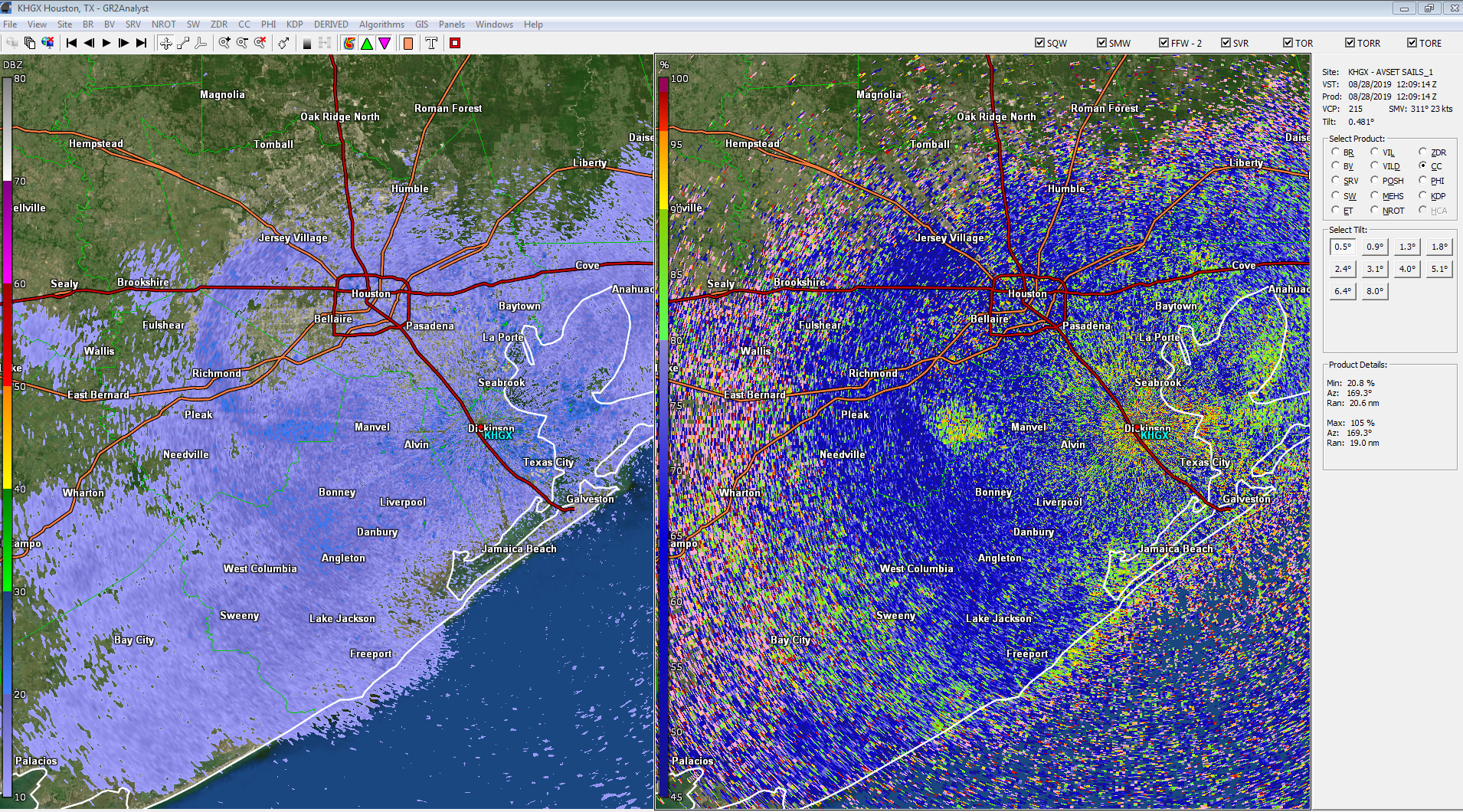
Think these are birds on the HGX radar this morning...

-
Just noticed the SPC has a slight over NE TX though. Will be interesting to see how that materializes.
-
You may not want to go around saying that word this far out lol. Looks more like a potential panhandle snow event as of now.