Indystorm
-
Posts
5,310 -
Joined
-
Last visited
Content Type
Profiles
Blogs
Forums
American Weather
Media Demo
Store
Gallery
Everything posted by Indystorm
-
Got a new enhanced risk from Chi town westward to eastern IA per SPC homepage graphic.
-
Storms congealing now over nw IA and eastern S.D. will definitely be the ones to watch today as they rapidly move eastward and crash into all the heat and humidity this afternoon. Gonna be an interesting day. Will be curious about the new SPC update. I think the earlier slight risk was placed too far south in MO and IL.
-
mhttps://www.cnn.com/2020/07/31/us/indiana-student-covid-positive-school/index.html In my recent geographical stomping ground before my move north to the Calumet region.
-
Some fair low level lapse rates but poor mid level rates and little shear means we will only see some isolated pop up svr later this Sunday evening in the WI/IL area. SPC indicating a watch will not be necessary. Heavy rain seems to be the main threat.
-
Jackstraw, I was busy with a move from Fortville to Griffith and not following our wxboard much during that time. Sorry you had such a severe episode but are now recovering. Thoughts and prayers are with you and big thanks to courageous medical personnel.
-
Just saw figures from medical authorities that over 200,000 Americans could be killed by the virus by the time we reach November if things continue at present rate. That is one third the number of those killed from four years of the American Civil War. Wear a mask and socially distance yourself. Part of America's problem is our rugged sense of freedom and individualism. But unlimited freedom is anarchy. That's why we have laws requiring seat belts, traffic laws, insurance requirements, etc. The public good of the community takes precedence over individual freedom in some situations. This has been our historical precedent. And I am very worried about those who are suspicious of scientific findings. Yes, conclusions may change as new data warrant. But there is a sound scientific method and peer review in science of which I am deeply appreciative.
-
Possible svr storm watch coming for St. Louis and central IL area per SPC meso discussion.
-
Yes, it has. Concerned about my old environs of Kentland Indiana if the storm keeps rotating and heading in that direction.
-
Confirmed tornado heading for Springfield Illinois and points just east.
-
Confirmed tornado near Chenoa IL moving east south of Pontiac along U.S. 24 corridor.
-
Tor warning now issued by LOT for Livingston County for the above warned storm.
-
BULLETIN - EAS ACTIVATION REQUESTED TORNADO WARNING NATIONAL WEATHER SERVICE LINCOLN IL 407 PM CDT WED JUL 15 2020 THE NATIONAL WEATHER SERVICE IN LINCOLN HAS ISSUED A * TORNADO WARNING FOR... NORTH CENTRAL MCLEAN COUNTY IN CENTRAL ILLINOIS... * UNTIL 415 PM CDT. * AT 406 PM CDT, A CONFIRMED TORNADO WAS LOCATED JUST EAST OF GRIDLEY, OR 14 MILES SOUTHWEST OF PONTIAC, MOVING NORTHEAST AT 20 MPH. HAZARD...DAMAGING TORNADO. SOURCE...WEATHER SPOTTERS CONFIRMED TORNADO. IMPACT...FLYING DEBRIS WILL BE DANGEROUS TO THOSE CAUGHT WITHOUT SHELTER. MOBILE HOMES WILL BE DAMAGED OR DESTROYED. DAMAGE TO ROOFS, WINDOWS, AND VEHICLES WILL OCCUR. TREE DAMAGE IS LIKELY. * THIS TORNADIC THUNDERSTORM WILL REMAIN OVER MAINLY RURAL AREAS OF NORTH CENTRAL MCLEAN COUNTY.
-
People are free to get the virus and possibly die if they want to, but not at my risk or expense. I recognize that some cannot wear masks for medical reasons. That is different. We are all in this together in my thinking. That is patriotism and love of country. I am pleased by the good vaccine news and hopeful that further extended testing will continue to prove safe and effective.
-
Ever since the April 2004 Utica Illinois tornado I am always suspicious of warm fronts in situations like this where higher temps and dews are just south.
-
Confirmed tornado near South Pekin and Tremont IL on that tor warned storm per LSR.
-
That tor warning for Tazewell county is in the Peoria area sweet spot historically for svr wx and tornadoes as many of us online have been reminded by Janet/Janet. I would watch the warm front as well as the usual warm sector to the south of it later today.
-
Yep, Cyclone continues to be under the gun in the latest warning for his area just ne of the Quad Cities.
-
BULLETIN - EAS ACTIVATION REQUESTED SEVERE THUNDERSTORM WARNING NATIONAL WEATHER SERVICE QUAD CITIES IA/IL 634 PM CDT SAT JUL 11 2020 THE NATIONAL WEATHER SERVICE IN THE QUAD CITIES HAS ISSUED A * SEVERE THUNDERSTORM WARNING FOR... EASTERN CEDAR COUNTY IN EAST CENTRAL IOWA... SCOTT COUNTY IN EAST CENTRAL IOWA... SOUTHEASTERN JONES COUNTY IN EAST CENTRAL IOWA... NORTHEASTERN MUSCATINE COUNTY IN EAST CENTRAL IOWA... CLINTON COUNTY IN EAST CENTRAL IOWA... * UNTIL 715 PM CDT. * AT 634 PM CDT, SEVERE THUNDERSTORMS WERE LOCATED ALONG A LINE EXTENDING FROM NEAR OXFORD JUNCTION TO NEAR LOWDEN TO NEAR ROCHESTER, MOVING SOUTHEAST AT 55 MPH. THESE ARE VERY DANGEROUS STORMS! HAZARD...80 MPH WIND GUSTS. SOURCE...RADAR INDICATED. IMPACT...FLYING DEBRIS WILL BE DANGEROUS TO THOSE CAUGHT WITHOUT SHELTER. MOBILE HOMES WILL BE HEAVILY DAMAGED. EXPECT CONSIDERABLE DAMAGE TO ROOFS, WINDOWS, AND VEHICLES. EXTENSIVE TREE DAMAGE AND POWER OUTAGES ARE LIKELY. * LOCATIONS IMPACTED INCLUDE... DAVENPORT, ROCK ISLAND, BETTENDORF, CLINTON, DURANT, ELDRIDGE, DEWITT, CAMANCHE, LE CLAIRE, WILTON, WALCOTT, BLUE GRASS, BUFFALO, ALBANY, PRINCETON, LONG GROVE, LOWDEN, WHEATLAND, GRAND MOUND AND WYOMING.
-
Chicago area point forecasts show 50% chance of t storms after 10 p.m. tonight. Would this be from storms moving in from the nw or from the boundary to our south moving back ne as a quasi WF?
-
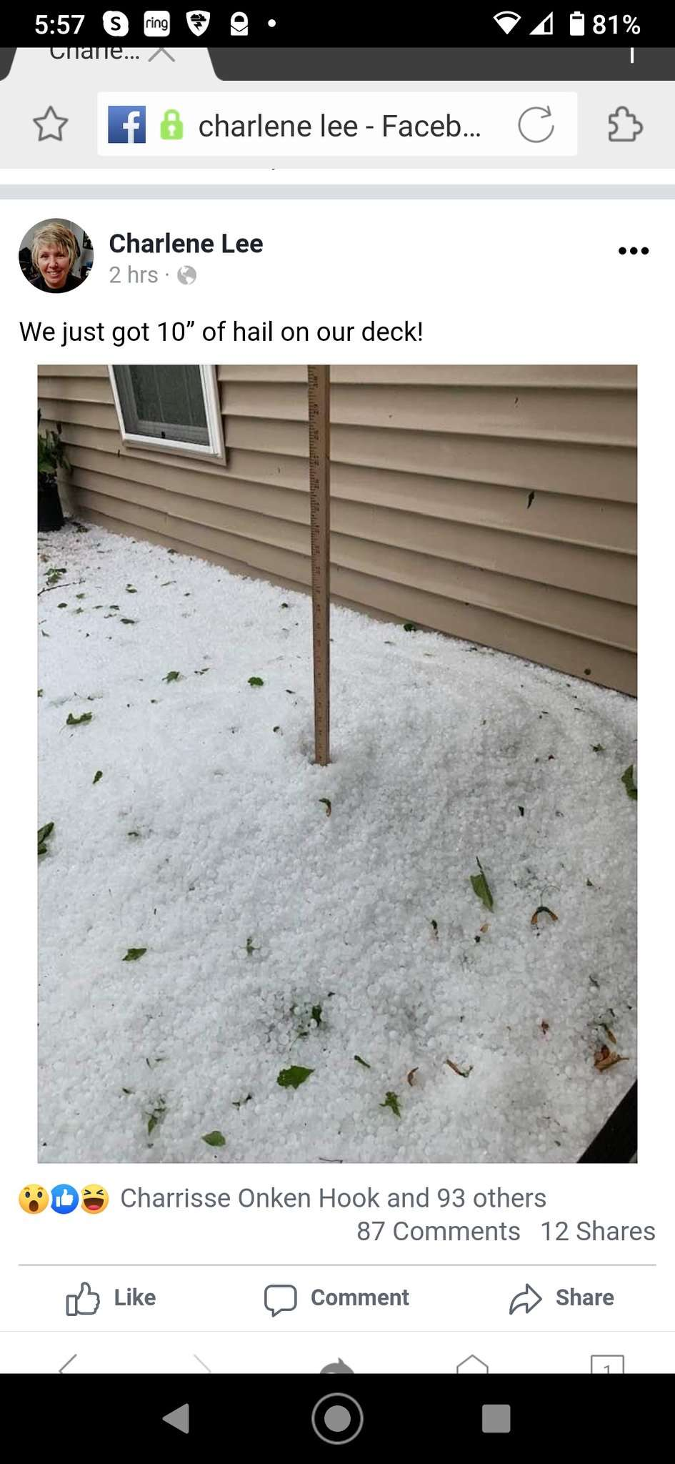
That ten inch hail report depth is from Brookston IN just north of Lafayette from a storm this afternoon. May be measured in some drifting, but crops and leaves were devastated in the area.
-
-
Yeah, that outflow boundary from noonday storms around Chicago metro might be strong enough to keep the nw/se axis of svr storms this Sat. eve a bit sw of Chicago area proper. Will have to see what happens. But mid week does look like a ring of fire scenario around here as has been stated.
-
Storms might lay down some good boundaries for later this evening in Chi town area. We'll have plenty of time to recover. These mid day storms moved a bit farther east than I initially expected.
-
If I didn't know where this was I would have thought tornado warnings from a tropical system as well since the storms are moving to the nw from the se. Highly unusual for this date and location. Low topped cells but latest SPC meso indicates a few tornadoes have been reported and areas farther east could be in play as the LLJ ramps up this evening.
-
Had the enjoyment of seeing their act several times while traveling through Vegas on vacation out west.