Upstate Tiger
-
Posts
974 -
Joined
-
Last visited
Content Type
Profiles
Blogs
Forums
American Weather
Media Demo
Store
Gallery
Everything posted by Upstate Tiger
-

The “I bring the mojo” Jan 30-Feb 1 potential winter storm
Upstate Tiger replied to lilj4425's topic in Southeastern States
Most of NC and SC still getting snow on the NAM at 39. -
The “I bring the mojo” Jan 30-Feb 1 potential winter storm
Upstate Tiger replied to lilj4425's topic in Southeastern States
Really good run for the western areas... -
The “I bring the mojo” Jan 30-Feb 1 potential winter storm
Upstate Tiger replied to lilj4425's topic in Southeastern States
Wonder how the short range models do sniffing out the meso low. GSP still confident this will develop and enhance rates in upstate and NC Piedmont. -
The “I bring the mojo” Jan 30-Feb 1 potential winter storm
Upstate Tiger replied to lilj4425's topic in Southeastern States
Where is everyone? Back in my day, we’d model watch and post all night, then go straight into work without any sleep. -
The “I bring the mojo” Jan 30-Feb 1 potential winter storm
Upstate Tiger replied to lilj4425's topic in Southeastern States
18 hours of snow IMBY in the NC Piedmont. -
The “I bring the mojo” Jan 30-Feb 1 potential winter storm
Upstate Tiger replied to lilj4425's topic in Southeastern States
Even our friend in Savannah getting in on the act 45 -
The “I bring the mojo” Jan 30-Feb 1 potential winter storm
Upstate Tiger replied to lilj4425's topic in Southeastern States
Snow really expanded in Ga at 42. -
The “I bring the mojo” Jan 30-Feb 1 potential winter storm
Upstate Tiger replied to lilj4425's topic in Southeastern States
She’s winding up at 39 -
The “I bring the mojo” Jan 30-Feb 1 potential winter storm
Upstate Tiger replied to lilj4425's topic in Southeastern States
Heavy banding along the NC coastal plain at 33 -
The “I bring the mojo” Jan 30-Feb 1 potential winter storm
Upstate Tiger replied to lilj4425's topic in Southeastern States
Funny seeing the cliff diving for those not getting 10”. I’m 61 and followed winter weather since 1976. The only 10” storms I remember in the upstate were the PD 1 1979, March 1983, and January 1988. Point being, it’s a rare thing to get 10” of snow in the SE. -
The “I bring the mojo” Jan 30-Feb 1 potential winter storm
Upstate Tiger replied to lilj4425's topic in Southeastern States
Would you change to a Tiger? -
The “I bring the mojo” Jan 30-Feb 1 potential winter storm
Upstate Tiger replied to lilj4425's topic in Southeastern States
Snow all across NC at 12z on Saturday. -
The “I bring the mojo” Jan 30-Feb 1 potential winter storm
Upstate Tiger replied to lilj4425's topic in Southeastern States
Good. I was terribly vexed by its existence and will not rue its demise. -
The “I bring the mojo” Jan 30-Feb 1 potential winter storm
Upstate Tiger replied to lilj4425's topic in Southeastern States
GSP AFD...they are indicating I-85 from GSP to Charlotte to be a potential jackpot zone with all of the western Carolinas and NE GA getting some stout totals. https://forecast.weather.gov/product.php?site=NWS&issuedby=GSP&product=AFD&format=ci&version=1&glossary=1&highlight=off -
The “I bring the mojo” Jan 30-Feb 1 potential winter storm
Upstate Tiger replied to lilj4425's topic in Southeastern States
Charlotte to the coast big winners on that run. SC also gets a lot of qpf. -
The “I bring the mojo” Jan 30-Feb 1 potential winter storm
Upstate Tiger replied to lilj4425's topic in Southeastern States
It did OK with the overall setup last weekend but totally missed the front end snow and sleet IMBY. -
The “I bring the mojo” Jan 30-Feb 1 potential winter storm
Upstate Tiger replied to lilj4425's topic in Southeastern States
-
The “I bring the mojo” Jan 30-Feb 1 potential winter storm
Upstate Tiger replied to lilj4425's topic in Southeastern States
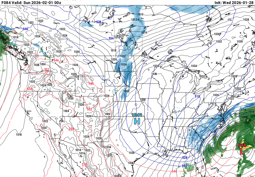
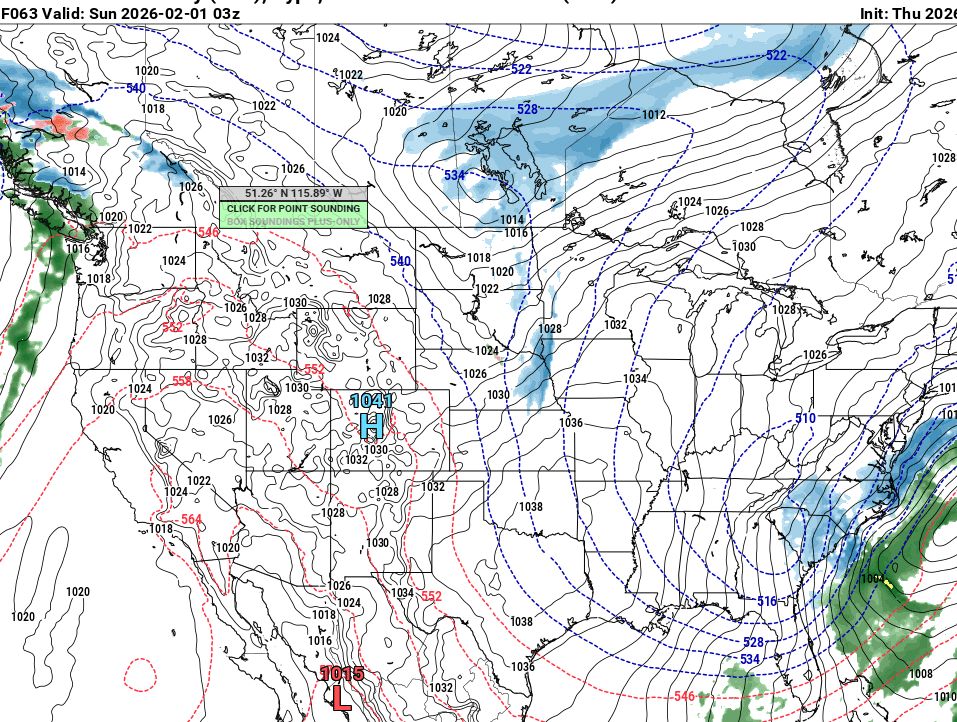
Man the Euro really shows the upstate and NE Ga as a potential jackpot zone along with the immediate coast. This storm has so many dynamics in play that it’s going to be tough to nail down details. That stupid Bahama low really screwed things up IMO or we’d have a traditional Miller A. When have you ever seen a low pressure system over the Bahamas in January? -
The “I bring the mojo” Jan 30-Feb 1 potential winter storm
Upstate Tiger replied to lilj4425's topic in Southeastern States
GFS pretty much holds steady. Another wild card is how anomalous this ULL will be. It will overproduce IMO. -
The “I bring the mojo” Jan 30-Feb 1 potential winter storm
Upstate Tiger replied to lilj4425's topic in Southeastern States
Where do I sign? -
The “I bring the mojo” Jan 30-Feb 1 potential winter storm
Upstate Tiger replied to lilj4425's topic in Southeastern States
GSP AFD... https://forecast.weather.gov/product.php?site=NWS&issuedby=GSP&product=AFD&format=ci&version=1&glossary=1&highlight=off -
The “I bring the mojo” Jan 30-Feb 1 potential winter storm
Upstate Tiger replied to lilj4425's topic in Southeastern States
CMC, GFS, and NAM all with basically the same evoluation. CMC is best for western members. -
The “I bring the mojo” Jan 30-Feb 1 potential winter storm
Upstate Tiger replied to lilj4425's topic in Southeastern States
Thanks! I had not seen that. Good grief...now we have to worry about a Low in the Bahamas. If there is a way to screw the SE, no matter how crazy, it seems to happen. -
The “I bring the mojo” Jan 30-Feb 1 potential winter storm
Upstate Tiger replied to lilj4425's topic in Southeastern States
I wish one of the mets would explain that Low in the bahamas. GFS has that feature as well. Just shown up in the last day. We are not seeing the earlier phasing or negative tilt we saw at 18z. Probably all noise at this point any way... -
The “I bring the mojo” Jan 30-Feb 1 potential winter storm
Upstate Tiger replied to lilj4425's topic in Southeastern States