

Met1985
-
Posts
16,909 -
Joined
-
Last visited
Content Type
Profiles
Blogs
Forums
American Weather
Media Demo
Store
Gallery
Everything posted by Met1985
-

2023-2024 Fall/Winter Mountain Thread
Met1985 replied to The Alchemist's topic in Southeastern States
Temp only dropped to 39 but only rose to 47 today under cloudy skies. Looks like a big warm up after this weekend. -
2023-2024 Fall/Winter Mountain Thread
Met1985 replied to The Alchemist's topic in Southeastern States
A beautiful sunrise this morning. Sent from my SM-G998U using Tapatalk -
2023-2024 Fall/Winter Mountain Thread
Met1985 replied to The Alchemist's topic in Southeastern States
More snow pics Sent from my SM-G998U using Tapatalk -
2023-2024 Fall/Winter Mountain Thread
Met1985 replied to The Alchemist's topic in Southeastern States
This is on the Balsam mountain range and at Waterrock knob. They had 1 to 2 inches of snow up there. Sent from my SM-G998U using Tapatalk -
2023-2024 Fall/Winter Mountain Thread
Met1985 replied to The Alchemist's topic in Southeastern States
Boy do I have a treat for yall! Sent from my SM-G998U using Tapatalk -
2023-2024 Fall/Winter Mountain Thread
Met1985 replied to The Alchemist's topic in Southeastern States
I believe it especially up there around 6k feet. Doesn't surprise me. We are sitting at 35 currently. -
2023-2024 Fall/Winter Mountain Thread
Met1985 replied to The Alchemist's topic in Southeastern States
Avery-Madison-Yancey-Mitchell-Swain-Haywood-Buncombe-Graham- Northern Jackson-Macon- 312 PM EDT Sun Oct 15 2023 This Hazardous Weather Outlook is for western North Carolina. .DAY ONE...This afternoon and tonight. Light snow showers are possible late tonight in higher elevations of the mountains above 5,000 feet. No significant accumulation is expected, but very minor travel impacts could occur Monday morning on high mountain roads. .DAYS TWO THROUGH SEVEN...Monday through Saturday. Light snow showers may occur at times through Monday night in higher elevations of the mountains above 5,000 feet. No significant accumulation is expected, but very minor travel impacts would remain possible on high mountain roads if the snow showers continue. -
2023-2024 Fall/Winter Mountain Thread
Met1985 replied to The Alchemist's topic in Southeastern States
Looks like some moisture is starting to be wrung out across the mountains. -
2023-2024 Fall/Winter Mountain Thread
Met1985 replied to The Alchemist's topic in Southeastern States
Nice! No rain here but we are at 46 here. Going to be a raw day today. -
2023-2024 Fall/Winter Mountain Thread
Met1985 replied to The Alchemist's topic in Southeastern States
This might bring a little something next week as well. All good signs in my opinion to this winter. Sent from my SM-G998U using Tapatalk -
2023-2024 Fall/Winter Mountain Thread
Met1985 replied to The Alchemist's topic in Southeastern States
The wind is already blowing 20 plus here. -
2023-2024 Fall/Winter Mountain Thread
Met1985 replied to The Alchemist's topic in Southeastern States
Gonna get windy blowing in that cold air. Madison-Yancey-Mitchell-Swain-Haywood-Buncombe-Graham- Including the city of Faust 241 PM EDT Sat Oct 14 2023 ...WIND ADVISORY IN EFFECT FROM 7 PM THIS EVENING TO 8 AM EDT SUNDAY ABOVE 3500 FEET... * WHAT...Northwest winds 25 to 35 mph at times, with gusts up to 50 mph possible. * WHERE...Elevations above 3500 feet in Madison, Yancey, Mitchell, Swain, Haywood, Buncombe and Graham Counties of North Carolina. * WHEN...From 7 PM this evening to 8 AM EDT Sunday. * IMPACTS...Gusty winds could blow around unsecured objects. Tree limbs could be blown down and a few power outages may result. -
2023-2024 Fall/Winter Mountain Thread
Met1985 replied to The Alchemist's topic in Southeastern States
Dang that's beautiful! -
2023-2024 Fall/Winter Mountain Thread
Met1985 replied to The Alchemist's topic in Southeastern States
06z gfs continues with high elevation snow. Sent from my SM-G998U using Tapatalk -
2023-2024 Fall/Winter Mountain Thread
Met1985 replied to The Alchemist's topic in Southeastern States
00z gfs showing some high elevation snows in the area. Sent from my SM-G998U using Tapatalk -
2023-2024 Fall/Winter Mountain Thread
Met1985 replied to The Alchemist's topic in Southeastern States
Yeah very surprised to wake up to moderate rainfall overnight. Picked up .42 inches overnight and this morning. -
2023-2024 Fall/Winter Mountain Thread
Met1985 replied to The Alchemist's topic in Southeastern States
Nice. A nice cold frosty morning. -
2023-2024 Fall/Winter Mountain Thread
Met1985 replied to The Alchemist's topic in Southeastern States
The gfs continues to flirt with a big trough towards the end of the month. Sent from my SM-G998U using Tapatalk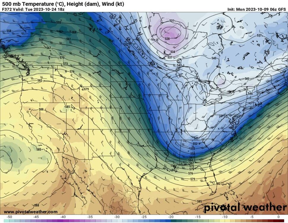
-
2023-2024 Fall/Winter Mountain Thread
Met1985 replied to The Alchemist's topic in Southeastern States
Impressive for you out that way. -
2023-2024 Fall/Winter Mountain Thread
Met1985 replied to The Alchemist's topic in Southeastern States
Yep day 2 was the winner. Had patchy frost in South Asheville and once I got into Haywood we had heavy thick frost. Current temp and low of 30 degrees this morning! This is what we've been waiting for. -
2023-2024 Fall/Winter Mountain Thread
Met1985 replied to The Alchemist's topic in Southeastern States
Temp down to 37 already. We are 3 degrees Colfer currently then we were last night at this time. -
No kidding! Two big plunges of cold air and some heavy mountain snow.
-
2023-2024 Fall/Winter Mountain Thread
Met1985 replied to The Alchemist's topic in Southeastern States
Not as cold as I thought it would be but we had a light breeze most of the night. Had a low of 35 with no frost except on top of the truck. Tonight will be our night to get a frost. -
2023-2024 Fall/Winter Mountain Thread
Met1985 replied to The Alchemist's topic in Southeastern States
Just a snapshot Sent from my SM-G998U using Tapatalk -
2023-2024 Fall/Winter Mountain Thread
Met1985 replied to The Alchemist's topic in Southeastern States
Good Lord the 6z went gang busters this morning! Sent from my SM-G998U using Tapatalk

